Category Archives: Geology

Exploring the Polar Park

Feb. 10, 2024:

The night of Feb. 8, we sailed around the Øksfjord and Skjervoy islands in the Norwegian Sea, and then yesterday (Feb. 9th), we sailed through the Norwegian Inside Passage (next to Tromsø) to sail back to Narvik.

The views in the Inside Passage yesterday were spectacular, and later in the afternoon, we sailed around the Skaland peninsula to come back into the inlets surrounding Narvik.  

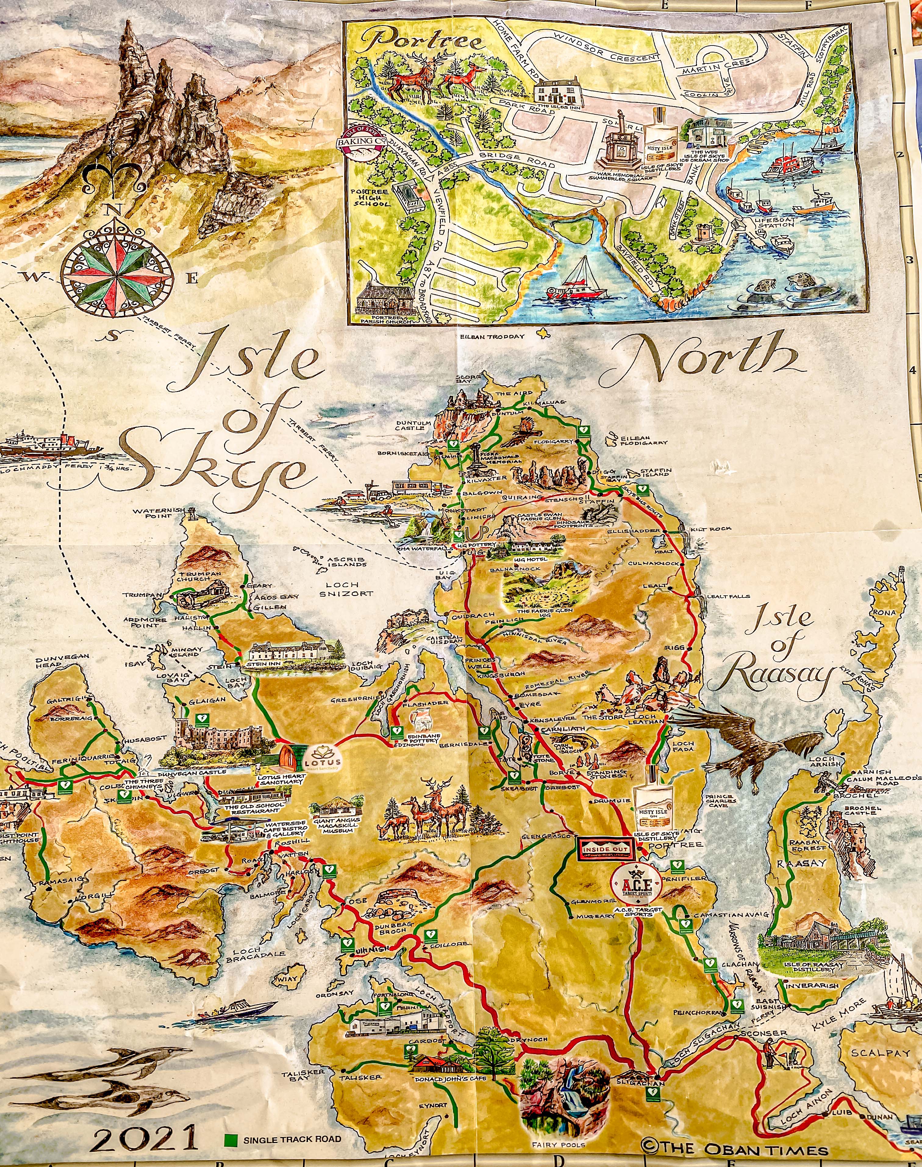
The Captain had to time the tides very closely, because getting into Narvik requires navigating some really narrow passages, and the tides can make or break the journey.  We woke up this morning with our ship docked in Narvik, which is the largest town close to the Lofoten Islands  (a natural wonderland off Norway’s northwestern coast).

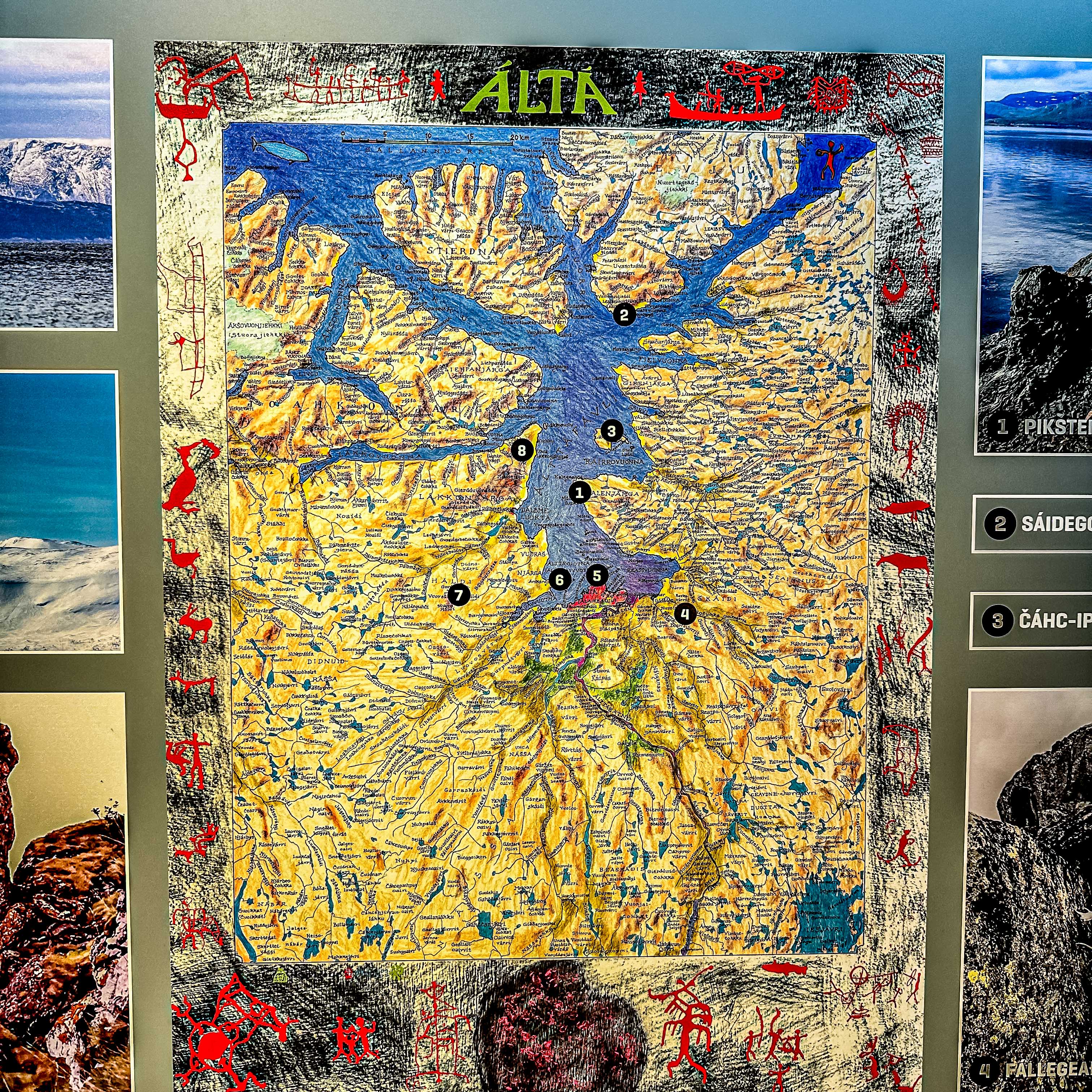
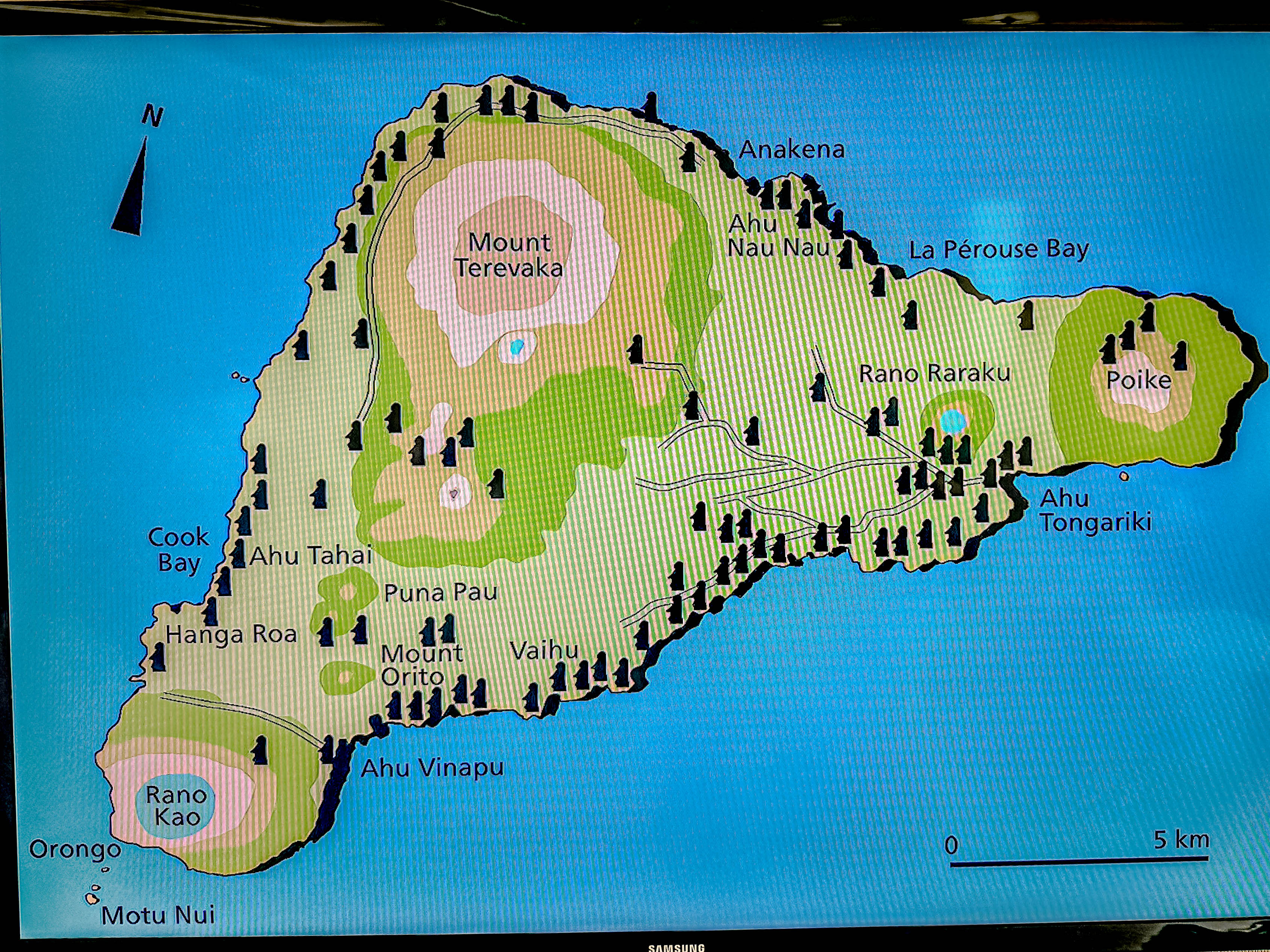
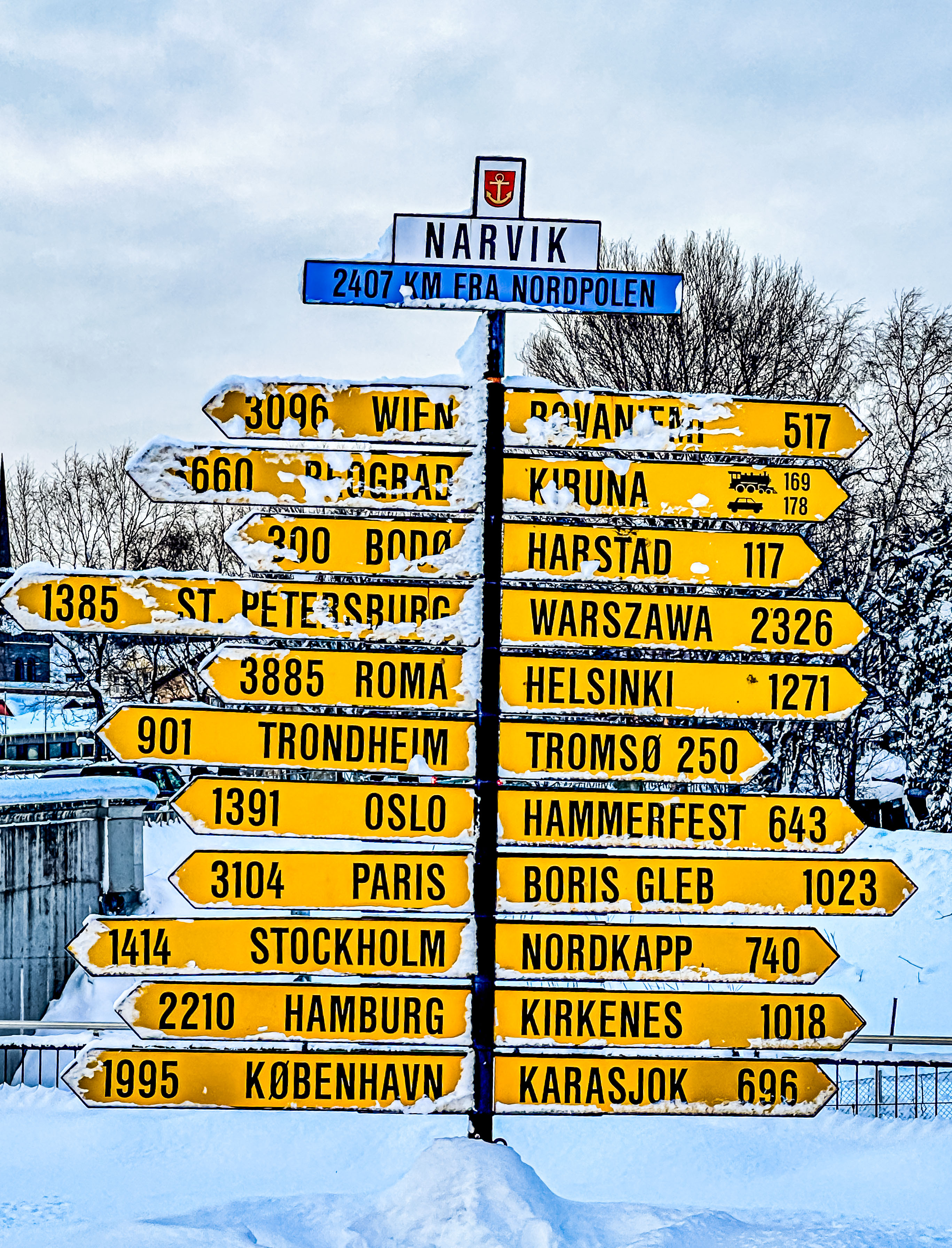
As you can see from the map, Narvik is incredibly close to the border with Sweden, and more importantly, incredibly close to the iron ore mines of Kiruna in Sweden. For this reason, Narvik was an incredibly important World War II strategic site in Norway, not only because of this close proximity to the mines, but also because the port of Narvik never freezes in the winter.  So it follows that the Germans also set their sites on Narvik as one of the three towns they had to capture first in 1940 when they invaded. The Allies (mostly the British) tried to mount a preemptive strike on Narvik, but they were really a day late and a dollar short, and the Germans ultimately won the day (although the British had landed an initial strike on the first German forces to land in the town).  Late arriving supplemental British forces (under the direction of Admiral Churchill) could not prevent the German attacks on the first British warships to secure the harbor, and the fact that another British vessel was busy spiriting away Norwegian King Hakon VII and his family and cabinet prevented the British from saving over 1,000 British sailors aboard those ships.  In a nutshell, Narvik was another complete loss for the Allied forces, and again, the Germans obliterated it and its infrastructure as they withdrew at the end of the war.

Since there is almost nothing to see of a historical nature in town, our exploration for the day is out into the countryside to see a rescue park for Arctic animals.  This attraction is called the Polar Park, and has a very good reputation for ethical care of its animals in large fenced enclosures with natural environments. The animals live outdoors all the time in burrows and other enclosures they build themselves (except for the reindeers and musk oxen), but they are fed by their naturalists.

The ski resort right outside of town.

Since this park is all outdoors in a natural setting, it does involve a fair amount of walking over snowy (and sometimes icy) paths of changing elevations (small hills only). To aid in this, the park has spiked bottoms for your boots which go on easily. Unfortunately, they can also slip off sometimes, so check your feet somewhat regularly, but I highly recommend using them.

The pathways through the Polar Park

We were already excited for our visit because we had spotted two moose roaming free on the drive up to the park. so I can say that we were less excited when the first animal we saw was the lone moose they had in captivity. However, things got a lot better fast!

Two female moose in the wild right outside of town.
Free range moose
The Polar Park’s lone moose.

First, we went by the deer enclosure to see the red deer.

There are two separate enclosures for the Arctic lynxes the park has in captivity. They are father and son, and apparently, lynxes are very solitary animals. We saw the son who was called Little Brown. One thing you notice immediately is that carnivores kept in captivity are plump, bordering on fat.  Little Brown obediently trotted to the front of the enclosure so the naturalist could toss him bits of reindeer meat. I assume this happens several times a day, hence his husky appearance.   He was a gorgeous animal, though!

The naturalist had the lynx trained to climb the fence to get his meat treats. Good that he gets some exercise!

Then we walked over to the fox enclosure. The Park has three foxes, who are all littermates; two girls and a boy. The ladies are the leaders of this pack , though, and the boy fox waits to eat until they are done. From the looks of it, though, no one is missing any meals!  These were the fattest foxes I’ve ever seen, and if they were dogs, their vet would put them on an immediate diet! We loved watching their antics, and they were so adorable that more than one person wanted to take them home.

From the foxes, we walked over to one of the wolf enclosures (there are three). In this first one, the wolves are all part of a pack who were raised together from puppyhood, and they are very sociable. So much so, that you can pay  extra to have a private session with them to pet them. Apparently, our tickets did not include this experience, so we looked on with envy while other guest were getting wolf love. These are beautiful animals!  We were able to get them to howl, which got all the wolves in the park joining in.  

Then we hiked up to the enclosure where the sole wolverine in the park lives. He was very shy, and we saw only fleeting glances of him. Not coincidentally, he was one of the thinner animals in the park, probably having to do with not being lured out by meat treats!

The wolverine enclosure is next to the bear areas, but we did not see them. These are brown bears, not polar bears because the environment here is not conducive to polar bears’ need for sea ice. But the bears were hibernating, so we missed them, which was probably good for their annual feeding/resting cycles.  If they are awake during their hibernating period, they start burning calories, and it can be a challenge (at least in the wild) for them to consume enough calories during the summer to safely hibernate.

The wolverine (or jerv in Norwegian)
Part of the bear enclosure infrastructure

We also walked over to one of the other wolf enclosures, where a pack of Swedish wolves were kept. They had been sent by a wildlife park in Sweden, and were not nearly so socialized, but finally, the lure of the raw meat tidbits was enough to draw them out. They had to really work, though, to get the meat before the crows dived in.

The Swedish pack

Then we walked over to the musk oxen enclosure, and this is the first time Jim I had ever seen them live.  One had been sighted on our Arctic cruise a few years ago, but we never actually saw it.  Their name is apt, as the smell of that enclosure was worse than driving past miles of dairyland!

Musk oxen

We thought we had seen all we were going to see in the park, and had started back to the base when we got extremely lucky, and spotted part of the reindeer herd which roams free all over the unpinned areas of the park.  They were amazingly graceful, even when walking through deep snow where they were grazing. I for one was happy to leave the Arctic having seen a reindeer!

It was starting to snow as we left the Polar Park, and it was a long a windy road back down to town and our ship. Whether it was the road, or our guide telling us all about the wonders of cod liver oil in your diet, Jim was so queasy out, he refused to go on on evening excursion; i.e., our last chance to catch the Northern Lights. I opted to hop off the bus in town and explore a bit, and enjoyed my walk back to the ship.  The port security guards had built a fire in a pit to stay warm, and it was a welcome sight as I returned to the ship.

Looking from the hills to Narvik harbor.
Narvik harbor
Ice formations on the stones.
Signpost in town
Local art installation
The old train station
Returning to the ship

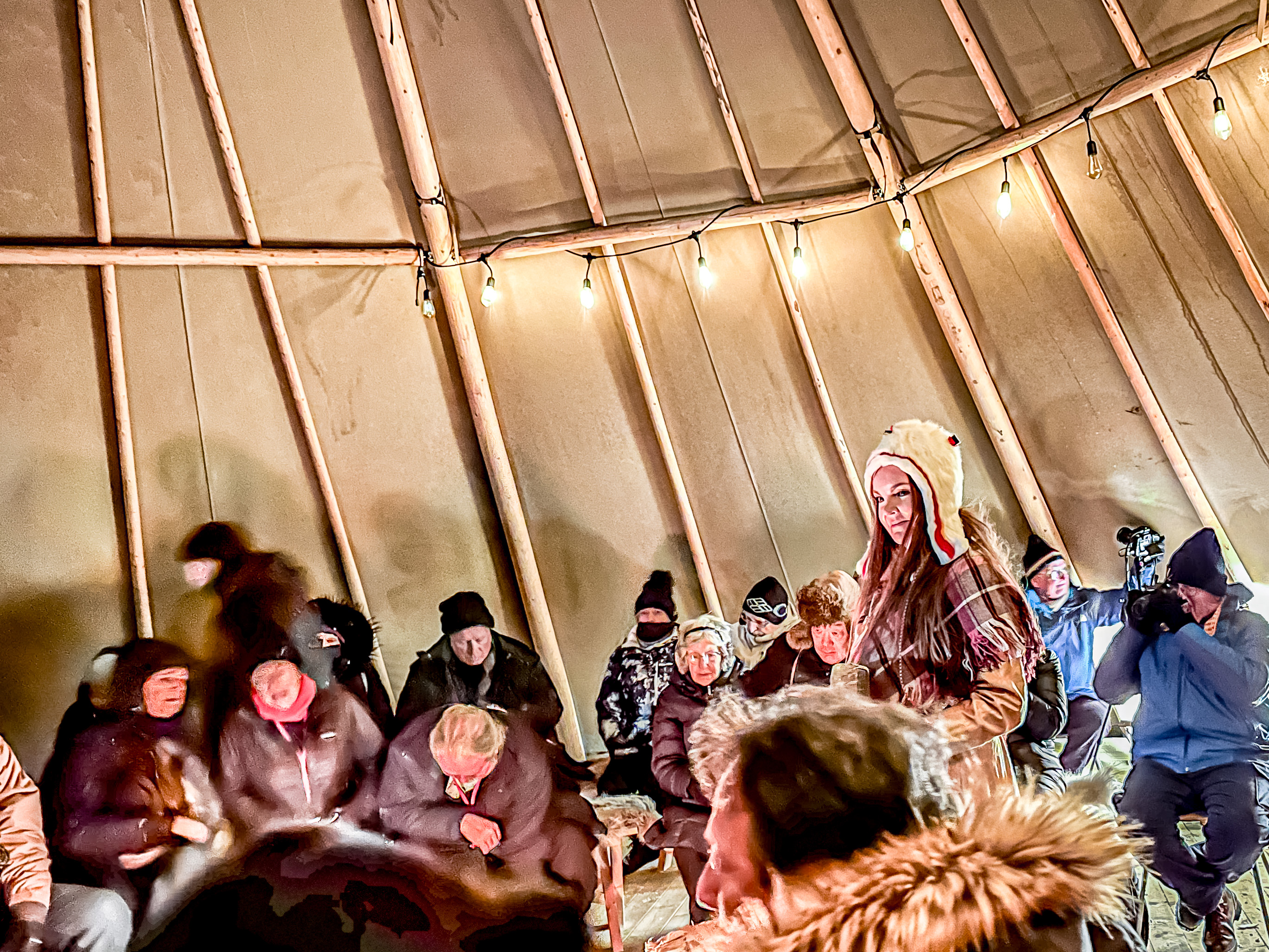
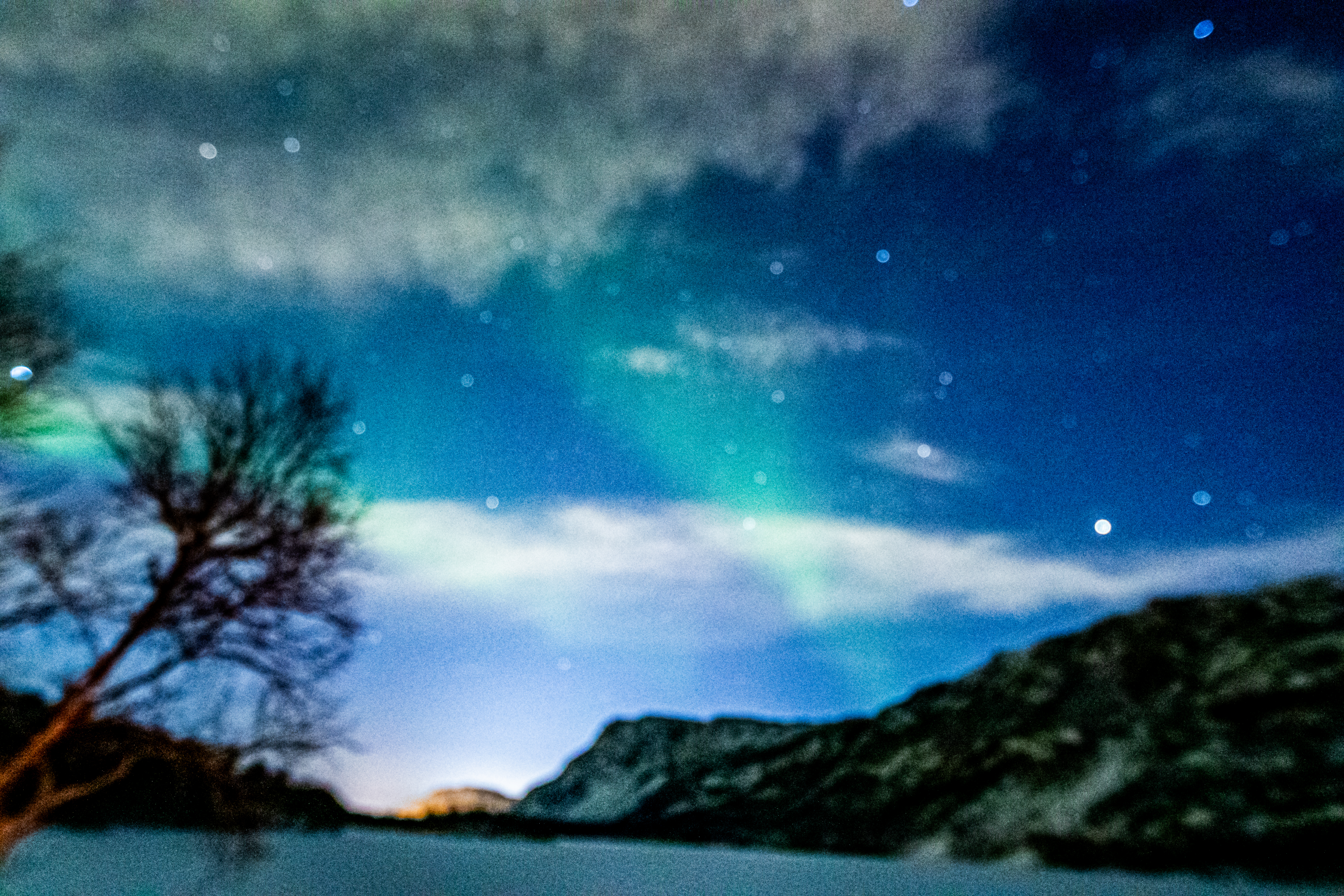
After driving longer than we had to get to the Polar Park, we reached a nice looking hotel, where they had a small snack for us, and let us sample the local beer. We kept dashing outside to see if we could catch the lights, but the clouds you see in the picture kept rolling in, so no go on the Lights that night.

Fortunately, the whole evening wasn’t a bust, as we were treated to songs (called “joiks” in Sámi) and stories of about the Sámi people and their customs. It didn’t hurt that there was a roaring fire in the wood and hide structure the Sámi called a Lavvu, which looks like the tepees of the American Plains Indians. Then we drove home.

Alta: the Land of the Northern Lights

Feb. 7, 2024:

After a late night last night, we slept late this morning, and partook of a late breakfast eating Norwegian waffles onboard. By the time we woke up, the sun was just coming over the mountain surrounding the port of Alta (at 10:00 a.m.!).  Fortunately, our excursion during the day today didn’t start until 1:00 in the afternoon!  Which was good, because it was a frigid 10 degrees outside (and that was the high for the day)!

Alta is the main town in the northernmost Norwegian County of Finnmark, with a total population of 70,000 people, 20,000 of whom live in town. But since we are in the heart of Sámi country (whose traditional pastime is reindeer herding), there are 180,000 reindeer. The Kven people (pronounced “kanne”) are Finnish descendants of workers in the fisheries and mines in the 1800s. As we mentioned yesterday, the indigenous people are the Sámi. Many live up in the plateau lands near the Russian and Swedish borders; and many are traditional reindeer herders. 70% of the people in Finnmark have Sámi ancestors.

There is also an airport here in Alta, which gets several flights per day. However, all the flights only connect within Norway, and Oslo is a two hours flight to connect to the rest of Europe.

Unlike Tromsø, which basically sits on a strait running between the island and the Norwegian mainland, and never freezes over; Alta is at the mouth of the the Alta River, which is frozen over now, and will remain that way until late April or May. Numerous rivers cross Finnmark, and most of them empty into the sea. For that reason, salmon use the rivers to spawn, and Finnmark is considered one of best salmon fishing areas in the world; especially the Alta River.

Alta claims the title of the City of Northern Lights. The season for the Northern Lights is from the end of August until March. Our guide (a transplanted Irishman) told us that in his opinion, some the best Northern Lights viewing is in October and November, when the temperatures are much milder, and the Lights tend to be better closer to the equinoxes. 

Alta is located seven hours north of the Arctic Circle, and it is the same distance from here to Berlin as from here to the North Pole! The town of Alta just came out of the polar night, so the residents saw sunlight the first time on Sunday morning (for the first time in 10 weeks)! At this high northern latitude, they gain one hour of sunlight per week. By the time they reach May, there are two months of uninterrupted sunlight (from the end of May until the end of July). 

Sadly, the town of Alta  and all its surrounding towns and settlements were completely destroyed by the Germans at the end of WWII because of its strategic value for the transport of many raw materials used in the manufacture of industrial goods. Even the livestock were destroyed, because the Germans wanted the Russians to have nothing to survive on when they retook the German-occupied areas. Consequently, many towns in Finnmark were never rebuilt post-war. The destruction was so complete that even churches were burned to the ground, with the exception of churches whose graveyards surrounded the church buildings, so only about three churches in the whole county remain from the pre-war era. The center of Alta was purpose-built in a new location (up on the bluff surrounding the town, instead of down by the water) after the war. Today, it is the only town in Finnmark which is growing. 

In addition to the Northern Lights, and the great summertime activities,  Alta is famous for the thousands of rock carvings discovered here dating from Stone Age (between 7,000 and 2,000 years old). There have been inhabitants in this area for 11,500 years. There are about 3,000 rock carvings, most of which are left in the open so the snow protects them from damage caused by freezing and thawing ice. Alta was obviously the former site of multiple trade crossroads, and artifacts have been left which establish this. Alta is the only UNESCO prehistoric site in Norway. Our prime objective for the daytime is visiting the Alta Museum, which has numerous examples of its stone art, as well as good exhibits about the Sámi culture and the industrial age of Alta.

Ceremonial headers of the Sámi people.
For thousands of years, the last little bear followed its mother, but then the broken piece of stone was lost (so long ago, the tale of the third little bear was forgotten). Finally, the slab turned up in the basement of a school in Finnmark, and the slabs were reunited.

In the modern period, Alta became the site of a huge mining area. Its most famous export is slate, and most of the homes in Norway with slate roofs have slate mined in in Alta. In the port area, you can see huge bulk container vessels exporting Alta slate all over the world. However, as the Industrial era progresses, Alta also became famous for mining tin, then copper, and nepheline syenite (used in glass, porcelain, ceramics and paint). The tin and copper mining operations were made possible by huge investments from the British, and developed into a world-class mining operation post-WWII. Fun fact: one of the biggest investors in the Alta mining operations was Lord Carnarvon, which gave him the wealth to fund the search for Tutankhamen’s tomb. 

The museum was fascinating, and a welcome activity on a day which did not warm up past 3 degrees F.  Jim and I particularly enjoyed the Stone Age exhibits, but there were also some good materials about the Sámi culture (and the gift shop was particularly nice). When we left the museum, the temperature had dropped, and it was snowing, which did not bode well for our Northern Lights chase later this evening.

Various sites of sacrificial rocks call sieidi along the Alta fjord
Ceremonial drum of the Sámi. The shaman would bounces a gold ring on its surface with each beat of the drum, setting the ring spinning. The symbol it stopped on would tell the shaman about the fate of the person who consulted him.
Traditional tunic of a Sámi man called a Gákti
Traditional fishing gear used by the Sea Sámi

We left the museum to view the oldest building still standing in Alta;  a Lutheran church, called the Old Alta Church.  In fact, it was the only building which survived the destruction of Alta, because it was a church with graveyard surrounding it. The church was opened in 1858, and the roof is slate. It is the first building commissioned to have a roof using Alta slate. Parts of it have been rebuilt several times, but the most recent was in the 1970s. Today, it only seats about 200 worshippers, because most Norwegians today are very secular. Alta also has the Cathedral of Northern Lights, which was built in 2013, and is now the main church in Alta. However, this church is still in use (particularly by older citizens whose religious lives took place here).

The old Alta Church
Most of the tombstones were lit with permanent lights so they didn’t have to sit in the dark during the long polar night.

Of course, no visit to Alta is complete without viewing the Cathedral of Northern Lights, so we did a drive by of its exterior. The titanium cladding is particularly imposing, and was designed to look like a swirl of Northern Lights.  However, if you want to see the interior, be aware that it is only open to the public from 11-1 during the week.

The new Alta Cathedral of the Northern Lights

We got back to the ship and sorted ourselves out because we were planning to go searching for the Northern Lights later this evening, this time was a Viator company called Alta Adventures. Since we remain in port overnight, at least we know we won’t have to cut the chase short to return to the ship. We ate an early dinner, and bundled up in multiple layers. Our weather apps were telling us that it was -1 degree F. and felt like minus 16F.

We drove first along the southern coast hunting for the lights, but had no luck.  We did see another church which escaped being burned by the Germans, though.

The abundance of stars boded well for finding the Lights.

Then they took us up into the mountains to the east of town, and set us up a little camp, including a fire and stools with reindeer skins. However, almost right away we could see the first glimmers of the lights, and the show got better!

We were in a really pretty valley overlooking a lake, but it was bitterly cold.  For once, we could see the Lights with our naked eyes. Sadly, though, somehow my camera got out of focus, and even with a headlamp, I could find the focus again. But even the most out of focus pictures shows the curtains of light and some of the amazing colors we saw.

All too soon, it was time to head back to the ship, but we will remember these sights for the rest of our lives!

Rhapsodizing in Rapa Nui

Jan. 25, 2023:

Dear Readers:

If, like the Gringos, you followed the exploits of Norwegian explorer and amateur archeologist, Thor Heyedahl, and especially his first voyage on the balsa-wood boat, the Kon Tiki, then I am sad to inform you that virtually all of his theories regarding the origin of the people of Easter Island (Rapa Nui) have been proven wrong. But his contributions to helping spread awareness of the people and their culture remain invaluable.

Rapa Nui (Easter Island) at dawn

On January 25th, we visited the island of Rapa Nui. It took us four and a half days of hard sailing from Lima, Perú to get here, as it is about 2,300 miles from the coast of Chile, which still claims it as a territorial possession.  Sadly, we were only in port one day, because to fully appreciate all the island and its people have to offer, you really need three to four days. The Gringos visited here in 2015, and covered our visit extensively in these prior posts:

First a little history, and a huge shout out to the Distinguished Speaker we have aboard, James Grant-Peterkin, for all his informative lectures about the people and culture of the Rapa Nui. James has lived mostly on the island of Rapa Nui for over 25 years, and he has some interesting perspectives. His book, “A Companion to Easter Island”, is probably the essential guidebook to take with you if you ever visit Rapa Nui, and a great read even if you don’t. 

Today, the origin of the people of Rapa Nui have been identified definitively as belonging to the Polynesian peoples who originated in Taiwan about 4,000 B.C. They had migrated as far as Tonga and Samoa by about 1,000 B.C. Polynesians had inhabited the islands of French Polynesia by at least 600 A.D., and were experienced and sophisticated ocean navigators by that time. They used a hub and spoke system of navigation where they made exploration journeys radiating in spokes out from their known location against the current, and sailed to the halfway point of their supplies, before using the prevailing currents to carry them back to their home base. They used stick maps to memorialize these journeys and the locations of other islands found, and also used astral navigation. From skeletal and linguistic similarities, it is believed that the people of Rapa Nui most likely originated from Mangareva or the Gambier Islands in Tahiti, although it is possible they came from the Marquesas Islands. In any event, the Polynesian people who discovered Rapa Nui had colonized it between 600-900 A.D.  Heyerdahl’s disproven theory was that the islanders had originated from South America, and his sea journey of 1947 of over 8,000 kilometers from the coast of Perú was intended to prove such origin was possible. It just didn’t happen to be true.

It is believed that after colonizing the island, and successfully launching a society there, that their society was essentially a closed one, and the Rapa Nui islanders did not maintain links with their original homeland. After some period of establishing their colony on Rapa Nui, Rapa Nui islanders developed their practice of carving the stone head statues by about 1,000 A.D.  In Polynesian culture, worship of the ancestors is prevalent, and what we now know is that the practice of building the stone statues was intended to provide a home for the spirits (the “manu”) of important ancestors like a chief or an important member of a tribe. For that reason, virtually all of them were erected facing inward, usually looking over the village which had them erected, in effect to keep watch over the villagers. At one point, there were 11 different tribes on the island. The stone statues, “moai”, were completely carved in the rock quarry of Ranu Raraku, except for the eyes, and then were transported to the site where there were erected and placed on the sacred platforms (“ahu”), where their eyes were carved out and coral inserts added, and the topknots “pukau” were placed on top. Only one ahu site has its moai facing the sea; Ahu Akivi. The period of carving and worshipping the moai lasted until about 1600 A.D. At some point thereafter, the islanders came to believe that the spirits had left the moai, and they were toppled, although it was possible that some of them were toppled by warring tribes.

The island was discovered by European explorers on Easter Sunday, April 5, 1722, by the Dutch explorer, Jacob Roggeveen, and gave the island its European name, Easter Island. Spanish explorer, Felipe Gonzalez de Haeda claimed the island in the name of Spain in 1770, tricking the islanders into signing some sort of “contract” for the island. Four years later, Captain James Cook pulled into the harbor desperate for supplies, but found none. Roggeveen and Haeda reported the moai were all still standing at the time of their visits, but by the time Cook appeared, he reported only some of the moai were still standing. By 1838, sailors visiting the island reported only one was still standing. Interestingly, no one really knows what the original name given to the island by its settlers. The term Rapa Nui does not appear until writings form that 1838 visit, but the islanders prefer that name to the name given by Roggeveen, and refer to themselves as the Rapa Nui people.

In the 1860s, after most European nations had abolished slavery, landowners in South America were desperate for laborers. In the 1860s, over 2,000 Rapa Nui were kidnapped from the island as slaves. The male islanders were especially popular because their height and strength meant they could be used in hard manual labor. Finally, an uproar arose about this practice, and a half-hearted repatriation project was launched, but only about 19 of the Rapa Nui were ever returned to the island, and they brought with them smallpox and other diseases which further decimated the Rapa Nui people. In the 1870s, Chile claimed the island as its territory to improve their naval defenses, and Rapa Nui is still a Chilean territory today.  For a chilling historical account about the repression practiced by the Chileans against the Rapa Nui, I recommend the following article, https://magazine.atavist.com/we-wish-to-be-able-to-sing-easter-island-chile-revolution/

In the end, though, the story you should take away about this island and its incredible people is how resilient they are, and how they are succeeding today despite centuries of Western abuse and neglect. The pandemic was a big blow to the tourism industry on the island, but all the Rapa Nui we met were incredibly warm and welcoming to us.  With daily jet service restored, it is now as easy to get there from Chile as flying to Hawaii.  This special place should be on your bucket list for the archeological marvel it is, and a gorgeous tropical paradise, as well!

Jim and I arose before dawn this morning to watch our approach to the island along its southern coast, and we were able to see all the way inland to the rock quarry where the stone moai statues were carved. We could also see into the interior of the Rano Kau volcano just as the first rays of the sunrise were hitting it. We sailed past the two tiny offshore islands to which competitors would swim in the Birdman competitions to name the future chief were held. 

Looking inland at the Rano Raraku quarry. The black spots on the hillside are the remains of moai, which likely broke during carving.
Crater of Rano Kau volcano. The Orango village from which the Birdman competition was held, is just over their side of the crater lip.
Interior of Rano Kau volcano crater.
Masked Booby flying alongside.

Our explorations here today covered four of the main highlights on the island.  We started by driving out of the closest thing to a port that Rapa Nui has, Hanga Piko.  We were incredibly fortunate to be able to land at all, as not only is this a tender port, but the tenders have to thread their way among rocks sticking out of the ocean like hungry teeth into a narrow harbor opening with perennially high wave and current conditions. In fact, every tender which goes into the port has to have a local pilot aboard to advise on the timing of the approach, and only one tender can come in at a time. 

We made it into the harbor, and our first destination was at the Ahu Tahai site, which is located the closest to the town of Hanga Roa.  It consists of three different ahu (platforms) which are the sites (from left) of Ahu Vai Uri, Ahu Tahai (the one with multiple moai), and Ahu Ko Te Riku, which has the distinction of being the only moai which has had replacement eyes put in it to simulate what all the moai should have had, and its topknot (Pukau) replaced on top. The whole site was restored by American archeologist William Mulloy between 1968-1970.  There are also the remains of the foundation stones for some of the original houses (hare paenga) in a boat shape.

Flag of Rapa Nui.
The Ahi Tahai site
Ahu Ke Ru Riku (left) and Ahu Vai Uri (right)
Ahu Ko Te Rico with our ship, the Mariner, in the background.
Hare Paenga (House Foundation Stones)
The Gringos on Rapa Nui.
Our friends, Barry and Carol

We then traveled along the southern coast to what I feel is one of the most moving sites on the island; the quarry at Rano Raraku, from which virtually all the moai on the island were carved. The stone here is different, consisting of a kind of solidified volcanic ash called lapilli tuff, which made it much easier to carve than the basaltic rock prevalent on rest of the island. There are 398 remains of moai scattered about the quarry, and the remains of the largest moai ever carved (21 meters tall), which was never finished is still affixed to the hillside.  This site just strikes me as magical!

Aerial photo of the Rano Raraku quarry-photo credit to James Grant-Peterkin.
The quarry at Rano Raraku.
View of the Ahi Tongariki site from the Rano Raraku quarry.
The Kneeling Moai

Very near to the Rano Raraku site is the site with the largest concentration of moai, Ahu Tongariki. Here, there are several noteworthy features. The most obvious, and probably the main draw is the giant ahu on which the remains of 15 moai have been re-stood. The restoration work was done by archeologists from Chile, with the funds raised by a donation drive in Japan after the most powerful earthquake in recorded existence ( 9.5 on the Richter scale) stuck the Chilean coast in 1960, and the ensuing tsunami with waves over 30 feet in height took the toppled remains of the Tongariki ahu and scattered them for hundreds of meters inland.  Other features to observe include the “Traveling Moai, a moai statue which has visited numerous coutries around the world raising awareness of the Rapa Nui and their culture, as well as some really great petrographs near the rear of the site. We did not visit these today as we had seen them on our prior visit. There are also a great collection of the pukai (topknots) which the architects were not able to re-establish on top of the moai.

The Ahu Tongariki site.
The Traveling Moai

Our final visit of the day, we explored the beach area of Anakena, which is where the ancient Polynesian colonists first made landfall in Rapa Nui between 1500 and 1700 hundred years ago. They arrived in double-hulled Polynesian canoes provisioned with all the things necessary to sustain a self-contained colony. The Rapa Nui they saw at that time was densely forested with palms, and had abundant fish and birds.   The site is important today, not only as the landing point for those colonists, but as the site where Thor Heyerdahl re-stood the first moai. The other ahu on the site, Ahu Nau Nau, was restored by a team headed up by archeologist Sergio Rapu, the first local-born archeologist in 1978.  This idyllic beach location offers some of the only food and drink on the island outside of Rapa Nui, and tourists and locals visit it primarily for its lovely beach.  When we arrived, barbeques were grilling loads of meat, and the bar was quite busy.  I walked across the field in front of the Ahu Nau Nau so I could get a great shot of the Ahu from above, but it is worth noting that the field and hill are uneven and liberally spotted with horse dung from the plentiful horse herds which run wild all over the island (and which make driving somewhat of a scary prospect).

Anakena Beach, with the Ahu Nau Nau.
The Ahu restored by Thor Heyerdahl.
The beach area at Anakena.

Once we finished with our visit to Anakena, we headed back to Hanga Roa over the spine of the island through some densely forested groves of trees (and dodged occasional loose cattle on the road).  My friend, Carol, and I asked to be dropped in town so we could look for a shop selling charms for the charm bracelets we are collecting from this trip. I think we found the one jewelery store in town, and the charms we selected were made by a local artist. Although we were assured of plentiful taxis to get us back to the little port of Hanga Pika, we didn’t find one, so we hoofed it back (about a mile and half).

Our day pleasantly complete, we took a tender back to the port, and celebrated a lovely sail away off Carol and Barry’s back porch.  

Just a small aside, we don’t know when Internet will be restored on the ship, so you’re probably reading this when we’re already in French Polynesia, but please stay tuned, as the adventures continue for the Gringos and their readers!

Boating Around Isla Bartolomé

Jan. 16, 2023:

Our explorations on Jan. 16th took us out to Bartolomé Island, one of the newest islands in the Galápagos archipelago, which lies just to the east of Isla Santiago. In fact, the last major eruption just took place about 100 years ago. This is a new location for us as we have not visited this island on our prior travels to Galápagos. The sail to get there takes about two and a half hours. Fortunately, the sky was overcast, so we escaped the worst of the equatorial sun while we sat up near the bow. Manta rays are endemic here, and we really enjoyed watching several of them leap out of the water (but didn’t catch photos of any of them breaching).

Manta ray getting ready to breach
Splash of the manta ray as it hit the water
Tips of a manta ray’s wings
The shoreline of Bartolomé Island.

Our explorations on Bartolomé were not for the faint of heart. We hiked up a long steep path to get to the crest of the island, from which you can see a 360 degree view of the islands.  One of the closest is Santiago, and also little Rábida Island.  Because it is so young, Bartolomé has almost no vegetation and looks like a moon scape. In fact, the only vegetation we saw were some small stubby cacti called Cava cactus, one of first colonizing plants that appear on new islands in the Galápagos.

About 1/3 of the way up the hike.
View from the peak
That is Pinnacle Rock in the background, favorite hangout for Galápagos penguins.
Cava Cactus
This sea lion was waiting for us on the steps where we landed when we returned from our hike.

After our hot and sweaty hike, we were happy to hop into the Zodiac to let the winds cool us off as we cruised around the area. We motored up past the big rock called “The Pinnacle”, where the Galápagos penguins are known to gather. We saw several of the penguins. They even jumped in the water to swim around the Zodiac, where they were joined by a curious sea lion. We even saw some Blue-footed Boobies up close.

Galápagos penguins, the second smallest species in the world.
Sally Lightfoot Crab
Sea lion in the surge.
Blue-footed Booby
Heron (Striated, I think)
Curious sea lion swimming around our Zodiac.

Then we returned to the boat, and changed into snorkeling gear. We moved down the island a bit and swam off a beach, which had pretty decent snorkeling, although not as good as yesterday. In my opinion, the best part of it was the fact that there were two more penguins on the rocks by the beach, and you could swim pretty close to them to take some good pictures. There were also huge schools of fish. Then we saw what looked like a giant turtle. In reality, it was a whole group of “happy turtles” in the act of mating, and they looked like a pile of turtles.  Natalie said it was all males in the group, except for one female. None of us envied her!

“Happy Turtles”

As we sailed back, the chef fed us lunch.  We passed many more jumping manta rays, but everyone agreed that the highlight of our return sail was the huge pod of dolphins we saw sailing back. They came over and rode our bowsprit surf, and I got to go out on the bow to watch and film them. Wow!

It was after dark when we returned to the hotel. We enjoyed our last dinner there and then retired to bed because tomorrow is going to be another long transit day.

Saints, Sheepdogs, and the Old Man of Storr

August 29, 2022:

We started our day on August 29th with a movie about the Isle of Skye at a great community space in Portree. The movie was called Skye Story. One of the historians contributing to the film, Cailean MacLean, joined us as our local guide for the day, which took us all the way up around the north end of Skye.

We began our explorations on tiny St. Columba’s Island in Portree Loch. As you know from our earlier post about the Isle of Iona, https://vayacongringos.wordpress.com/2022/08/24/voyage-to-iona/, there are three islands dedicated to St. Columba, the peripatetic Irish monk from the sixth century. Iona was the first, but this tiny island is the second. Don’t ask me where the third is! The cathedral on this isle was documented in Norse writings from the 11th century, but it is believed the isle was in use from 7th century. The island has also been used as a cemetery for centuries, and remained in use until 1966. The knight’s grave dates from the 15th century, and the gravestone is probably carved from marble on Iona. The mausoleum was the main burial place for clan MacLeod in the Hebrides.

Coming over the bridge onto Columba Island
MacLeod Mausoleum
The 15th century knight
I’m not clowning around!
Cailean MacLean

Then we began our drive up the island for a visit to locally famous sheepdog breeder and trainer, Seumas Campbell, on his croft. During our drive, Cailean had plenty of time to tell us more about the isle of Skye.

The earliest settlement found on Skye dates from 10,000 years ago, in the period of relative warmth between the ice ages. The settlements were probably temporary in summertime, when people came from the mainland to fish and gather berries. Gaelic has been spoken here for 1500 years, but many of the place names are Norse, from the Viking raiders. Vik is from the Norse word for bay. They were the progenitors of the Macleod and MacDonald clans, who predominate in this island; with the MacDonalds on the west, and the MacLeods on the east. The two clans battled constantly until late the 16th century.  A truce was attempted between the clans by having a MacLeod lady marry a MacDonald man. But instead of a regular marriage, they tried what was known as “handfasting”; a kind of temporary marriage which lasts just a year unless the union produces a child. In this case, no child was born, and the handfasted MacLeod lady was returned to Clan MacDonald. This caused the War of the One-Eyed Woman, resulting in a final battle in 1601. The King, in disgust with the warring clans, passed laws to curb the power and barbarity of the clan chiefs.

Time in Scotland still tends to be broken into two periods: the time before the Battle of Culloden Moor (April 16, 1746), which ended the last Jacobite Rebellion trying to overthrow England’s rule, and which heralded the end of the clans in Highland Scotland; and the time after.  For the wealthy nobles in the Scottish Highlands, many of whom had supported the Jacobites, they were imprisoned, stripped of their lands and titles, and many were transported to the American colonies if they were not executed. For the poor farmers of Scotland, called crofters, their ties to the lands were through a feudal system of land ownership where the lands were owned by the leaders of the clans (lairds), but it was largely a familial system because the landowners and their tenant farmers were usually related. Life wasn’t easy for these crofters, particularly in the Highlands, where the rocky hills and the extreme climate was always a challenge. However, those crofters were generally able to sustain themselves and pay their rent to their lairds.   After the Battle of Culloden, the whole system was disrupted. The lairds were replaced with other owners, typically Lowland Scottish lairds or English noblemen who had contributed to the defeat of the Jacobites. The new landowners were often hostile to the crofters, and there were no longer family ties to cushion the challenges of farming in such a harsh climate.  Later in the 18th century, those same landowners decided it was far more profitable to run sheep on those lands traditionally farmed by the crofters, and they started the Clearances, to remove the crofters from their lands. Often, the crofters’ homes were burned, or the crofters were forcibly moved to far-less productive lands.  Many of those same crofters immigrated to the United States and Canada. In fact, most of the Skye immigrants went to North Carolina in the United States.  The potato famine in the mid-19th century was not as severe in Scotland as in Ireland, but it was still devasting to the crofters. As a result of that scourge, even more Scots emigrated to the new world, leaving for Australia and New Zealand, in addition to the United States and Canada. The Skye immigrants in the 19th century mostly went to Prince Edward Island in Canada and to New Zealand. 

A croft now abandoned and running sheep.

It was not until 1871 when laws were finally passed to protect crofters, but for the majority of Scotland’s population who had died or left, it was too late.  However, those laws do provide some protection to modern crofters like Seumas who are farming using more modern technology and techniques.  But as Seumas would later tell us, even with those methods, and running four crofts, he is only able to make a living in today’s world by supplementing his income breeding and training sheepdogs, and doing demonstrations for tourists.

We passed some standing stones by the loch, which were supposed to hold a huge kettle, supposedly placed there by the legendary Finn MacCool. We also passed a stone tower called Fraser’s Folly, built by the locally unpopular Captain Fraser.

The standing stones
Fraser’s Folly

We turned inland in the ferry port of Uig, and drove up a glen called Balnacnoc, although it’s commonly known as “Fairy Glen”, and rendered famous by Instagram tourists. Our plan is to meet Seumas Campbell, a full-time crofter, who owns one croft, and rents three other crofts in order to make a living. But last weekend, Seumas achieved national notice when he won the Scottish National Sheepdog competition for running his pair of sheepdogs Bell and Queen) to herd sheep in the competition. We’re here to learn about life as a crofter in modern Scotland, and, of course, to watch Bell and Queen at work.

The Fairy Glen where Seumas grazes his sheep
Seumas’ Farmhouse

Crofts includes both the “in by” area, where crops are grown which belong solely to the croft holder, and virtually unlimited “common grazing area”, where everyone can communally graze their livestock. Sheep are marked with different colors of spray paint to tell whose animals they are. After watching border collies Bell and Queen do their stuff, we got back on the road. But not before Bell and Queen herded some of the ducks and chickens.

Our next stop was at Kilmuir Cemetery to see grave of Flora MacDonald. The Skye Boat Song popularized the story of Bonnie Prince Charlie’s flight from the Culloden Battlefield, and his escape to France with the help of Flora Macdonald, who was from Skye. The song has been used as the theme music for Outlander, and has more verses than I can count. Flora disguised the Prince as her serving maid and secreted him out to Skye, off which, he was finally able to get picked up by French sailors who carried him to safety. For her trouble, Flora MacDonald was arrested, tried and sent to London to jail, but she was finally released, and she married and then immigrated to North Carolina. After her husband’s death, she returned to Skye and is buried here.  The graveyard is also home to the grave of fashion designer Alexander McQueen.

Looking to the west towards Harris and Lewis from Kilmuir Cemetery
Flora MacDonald’s grave
Alexander McQueen’s grave
North shore of Skye
Rock formations in northern Skye

We stopped for lunch at a terrific community center called Columba 1400, which was set up to commemorate the 14 centuries since St. Columba’s death. However, it is a not a religious based charity. Rather, it strives to live the values of St. Columba (integrity, awareness, focus, creativity, perseverance, and service)  by providing leadership academies to inner-city youth living in poverty, and also training academies for teachers serving that population.

Columba 1400
The cafe operated by Columba 1400
One of the session rooms at the center

Then we were off again. The Isle of Skye is about 60 miles long. This time we made a brief stop to see the basaltic column cliffs called “Kilt Rock”. Again, these rock formations are part of the same massive volcanic explosions millions of years ago which formed the Giant’s Causeway in Northern Ireland and on Staff Island in the Outer Hebrides.  As a special treat, we also got to see and hear a young Scottish piper dressed up in his Highland regalia (wearing the Isle of Skye tartan, which was only created about 20 years ago). From where we are standing, we are on a headland jutting out on the most northwest point of the Isle of Skye. It looks out to the west toward the Shiant Islands (which means “enchanted”). 

The Black Cuillan Hills
Kilt Rock
The Shiant Islands

At this point, you might be justified in thinking we were done for the day, but, no.  We made another stop at the Lealt Falls and at a monument to the people of Tobhta Uachdrach. We looked over a vast open space where hundreds of families from five villages once lived. However, they were cleared from their lands in the early 1800s, and most of them immigrated to the Carolinas in the United States and to Canada.

Least Falls

Finally, we stopped to gaze at the amazing stone fingers which jut up out of the earth at the rock formation known as the Old Man of Storr.  We got some great views thanks to Cailean’s advice. Tired and happy, we returned to Portree. Jim and I took advantage of the knowledgeable bartender at our hotel to do a comparison tasting of the various single malt whiskies made by the Talisker distillery in the island.

Back side of the Old Man of Storr
Coming back into Portree

Jim and I had an excellent meal with Bill and Ginny from our group at the Dulse and Brose restaurant in town. Weirdly, for an island with a total population of only 11,000, there are four Michelin-starred restaurants. But be warned, none of them are open on Sundays, and currently, none of them are open Mondays, either. Stay tuned, because tomorrow, we move to the Isle of Lewis and Harris.

Voyage to Iona

August 24, 2022:

We awoke in the Inner Hebrides in the channel leading into the isle of Iona on August 24, 2022. The weather gods graced us with a glorious day.  The isle of Iona is a famous pilgrimage site where Saint Columba founded a monastery in the 6th century. St. Columba followed in the tradition of the other great questing monks from Ireland. For example, St. Columba was a disciple of St. Brendan, who was born in County Clare, Ireland, and went voyaging in the 500s for seven years. Columba was born in what is modern day Donegal.

Iona and the Abbey onshore

As a Catholic monk, St. Columba took his evangelism seriously, and he and 12 disciples set off from Ireland to Scotland in a small wicker and leather boat in 563 AD.  He first landed on the west coast of Scotland near Argyll, but as they could still see Ireland on a clear day, he decided to venture further afield. He spread Christian religion across Scotland, and especially focused his missions among the Picts of the Highland areas. He is credited with having performed a miracle by saving a man on the banks of Loch Ness from being devoured by a water monster (Nessie, perhaps?). 

His cousin, king of the Dál Riada kingdom of the Gaels (Ireland and western Scotland) gifted him with the island of Iona, and he founded a monastery here, which became the birthplace of Christianity in the British Isles. It became not only a great center of learning and literacy (the Book of Kells are believed to have been written here), but Iona became the center of Christianity in Scotland. Over the years, Columba traveled further afield in Scotland on his evangelistic mission, and is credited with having converted the King of the Picts, King Bridei, to Christianity in his kingdom based in Inverness.  Columba also converted another powerful Druid lord, Emchath, to Christianity on his deathbed. Emchath was the ancestor of the lords of Urquhart Castle, the clan Gordon. Columba died in 586 AD, and was buried at his monastery in Iona. The monastery and the cathedral built next to it became a great pilgrimage site. Notwithstanding that, there are other churches dedicated to St. Columba all over Scotland. Some time later, St. Columba’s relics were sent to Ireland. However, the monastery fell into disrepair, until the Benedictines arrived in the 1200s. Most of the restored Abbey you see today is from the Benedictine period.

The restored Abbey from the sea.

It is hard to overstate how lovely this island is in the late summer sunshine!  We started our tour with a walk to the ruins of a nunnery, and the old abandoned parish church for the residents of Iona (called the “black church”). There is also a graveyard here, with the gravestones of those who gave their lives in service to the people of Iona, including the nuns of this nunnery.

Coming into the village of Bailę Mór
A glorious late summer day!
The ruins of the nunnery
The graveyard in the nunnery
The old village church (“black church”)
Walking along the funerary road

We then walked along the road which used to be called the “funerary road” when it was built in the 1500s, and used to be marked with Celtic crosses all along the road. We saw MacLean’s cross, and then some great produce gardens which serve as produce for someof the island hotels and restaurants. We passed MacLeod House, which was the home of George MacLeod, a WWI hero. He returned to Glasgow after the war and saw the sad plight of the poor young men in town who were struggling to find work and feed themselves. He envisioned a plan to solve that problem by training the men to become stone masons and employing them year ‘round by bringing them to Iona to rebuild the Abbey. He also founded the Iona Community, which was the organization which undertook to restore the Abbey and keep it in good repair over the past 100 years.

The Parish Church which is now the center for the Iona Community’s preservation efforts
George MacLeod’s home
Produce gardens for the island’s hotels

From the entrance to the Abbey grounds, there was a huge cemetery, which is called the Graveyard of the Kings. There is some question whether the historical figure who was the basis for MacBeth is buried there. But there is no doubt that British Prime Minister John Smith, who died suddenly before taking office is also buried here. From the graveyard, you can look across the Iona Strait at the at Isle of Mull. Robert Louis Stevenson’s father was stationed there, and Robert Louis Stevenson is buried right across from Iona.

Graveyard of the Kings
Looking across to the Isle of Mull.

As you approach the church and the Abbey, there is a large Celtic cross called St. Martin’s cross, which is 1300 years old. We went into the cloisters for the Abbey first. To give you an idea how much work has been accomplished by George MacLeod’s stonemasons, only 2 of the original pillars remained here before reconstruction. The gravestones of those buried in the cloisters have been set upright along the walls.

St. Martin’s Cross
Entrance to the Abbey Church
Walking through the cloisters
The Shrine to St. Columba is the small outbuilding to the left of the entryway.

Then we went into the Abbey church. The current footprint dates from about the 1300s, and was intended to mimic the cruciform layout of the Church of the Holy Sepulcher in Jerusalem. There is a beautiful green marble altarpiece carved from marble on southern Iona. On the wall, the carved images of the monkey and the cat are the symbols of the Benedictine order, who took over responsibility for the church here in about 1200. We also visited the Shrine to St. Columba, believed to be where he was first buried.  

From this picture, you can see the cruciform layout of the Abbey Church.
Small bronze sculpture showing St. Columba and his 12 disciples setting off for Scotland.
Green Iona marble altarpiece
St. Columba’s Shrine
Inside St. Columba’s Shrine

We wandered around the town a bit before heading back to the ship for a little lunch before our next activity; hopefully, a landing on Lunga Island in the afternoon for the opportunity to walk among a colony of puffins.

Heather is blooming all over!

Alas, the seas were way too rough to allow us to land once we sailed out to Lunga, so the Captain steered  us to Staffa Island instead. You can see from the winds blowing the tops of the waves how hard the wind was blowing. Staffa is known for its basaltic columns which are the continuation of volcanic eruptions which formed the Giant’s Causeway in Ireland. We also sailed by Fingal’s Cave, known for its perfect acoustics, and was named after the eponymous hero of an epic poem by 18th-century Scots poet-historian James Macpherson. Mendelssohn composed an overture known as the Hebrides Overture, aka “Fingal’s Overture” for the cave.  We sailed around the island and admired its features, and then set sail back to Mull. Stay tuned, because tomorrow we will visit Duart Castle, the traditional home of Clan MacLean.

Wild winds!
Staffa Island
Basaltic Columns
Fingal’s Cave

Hieing (Getting) Ourselves to the Hebrides

August 21, 2022:

As we dropped anchor this morning, August 21, 2022, in the Hebrides Islands off western Scotland, we have sailed from the North to the east. Where we are anchored near the Shiant Islands, we are to the west of the Isle of Skye and to the east of the Isle of Lewis and Harris.  Our goal for this morning’s explorations is to take Zodiac cruise around the Shiants, looking for wildlife and viewing the basaltic columns making up the Shiants. If you have been to the Giant’s Causeway in Northern Ireland, these islands are a continuation of the basaltic columns which were formed by the rapid cooling of a volcanic eruption eons ago.  These deserted islands are home to varied sea bird colonies, including Shags (the British name for cormorants), guillemots, and maybe puffins. Additionally, we were on the lookout for Atlantic Gray Seals, and maybe a whale or two.

While the weather was cool that morning, it was clear, albeit with a high swell. We loaded up the Zodiacs and went exploring. The rock formations were really beautiful, and covered with brightly colored lichen in many places. Mostly the birds we saw were gulls, but they looked very comfortable tucked up into their rock crevices.

As we passed a small rock outcropping of gray seals. They mostly jumped in the water as we got near, but then they had fun swimming around our Zodiacs. We also found a hole in the rock outcropping.  But some stayed on the rocks along with their cormorant pals. All too soon, it was time to return to the ship, as we had a very full schedule that day.

Gray seal checking us out with cormorants on the rocks

The ship sailed southwest towards Skye through the Inner Minch (a tough waterway in the inner Hebrides), and anchored in the Loch of Dunvegan. We had our choice of two activities for the afternoon: travel inland on Skye to do a very vigourous hike at the Old Man of Storr (some spectacular rook outcroppings) in the Cuillin Hills; or take a sunset tour of the gardens and castle of Castle Dunvegan. Jim, Barbara, and I chose the latter, while Neil, Ellen, and Donna took the more rigorous choice.

We were anchored in Lock Dunvegan on the left. The Old Man of Storr hike was completely across the island, and slightly to the north. The drawing in the upper left is what the Old Man of Storr looks like.
Dunvegan Castle

We went ashore in the “gloaming” (as the Scots call the soft light of sunset) to visit Castle Dunvegan. A Scottish piper piped us ashore. The gardens were a glorious late-summer riot of colors, but unfortunately, as is often the case in Scotland on fine days in the summer, the midges were out in force in the humid evening.  We saw as much of the gardens as we could before the midges ate us alive, and then we escaped them into the castle. Dunvegan is the ancestral home of the MacLeod clan, who still own the castle. Its construction was begun in the 13th century. The MacLeods are a very prominent clan here in western Scotland, especially in the islands. There were extensive historical exhibits in the castle, including quite a few concerning Jacobite Rebellion of 1746. One of the MacLeod clans-people, Flora MacDonald, was key to helping Bonnie Prince Charlie escape Scotland after the disastrous battle of Culloden Moor on April 16, 1746, as was Donald MacLeod, who helped sail BPC through the islands escaping British capture until he could be picked up by a French boat and taken to safety in France. Both Flora and Donald were imprisoned for their actions, but both survived to return home to the islands. The daughter of Flora MacDonald married one of the MacLeod Chief’s sons and donated these pieces of memorabilia to the MacLeod family.

The piper piping us ashore.
This garden had the most vibrant hydrangeas I have ever seen.
The entrance to the Castle
The Laird’s bedroom
The dining room
The Laird’s Library
The view from the library
Waistcoat belonging to Bonnie Prince Charlie, gift to Flora MacDonald
Jacobite toasting glasses, including a gift from BPC to Donald MacLeod
Flora MacDonald’s Shawl and Corset
The Great Sword of Dunvegan, forged in the 1500s out of Scottish iron for the MacLeod Chief.

After admiring the views over the loch, we returned to the ship for a late dinner. Tomorrow we will have more explorations on the Isle of Skye.

View up Loch Dunvegan
And then the piper piped us back aboard our ship.

An Improbability of Puffins!

August 16, 2022:

The weather gods were still smiling on us when we pulled into the port of Heimaey the morning of August 16, 2022: Jim and I had visited here before, and had experienced the bone-chilling cold you often find on this exposed archipelago of islands off Iceland’s southwest coast.  Since we were going out on a boat around the island to see the puffin colonies (the largest concentration of Atlantic puffins in the world), we were happy for some sunshine!  Heimaey is a tiny place, and the town was nearly destroyed in a volcanic eruption in 1973. There’s a great volcano museum in town, but our goal was to see puffins, and see them we did!

The Heimaey town mascot in the harbor.
Puffin paddling
Puffin burrows.
Puffin burrows

The cliffs of these islands jut straight out of the water for hundreds of feet. Most of them are covered in succulent long grass, which provides the perfect habitat for puffins to dig their burrows to hatch their chicks. Conveniently, they also provide great foraging opportunities for the sheep grown by the townspeople of Heimaey.  Where the rock faces are exposed and no grass grows, other species also make their nests.  It is hard to capture in these pictures just how dense the birdlife was. The entire sea around the ship where we were at anchor was covered in fulmars floating on the tide, literally as far as the eye could see. As we approached the nesting areas, fulmars and puffins dotted the sky overhead.

Our boat trip took us around the island, and we were able to see the newest part of the island, added  by the volcanic eruption in 1973.  Then we returned to the ship for our sail to the tiny town of Djupivogur on the southeastern coast of Iceland. As we sailed away, we saw a small pod of orcas. Our captain had one more special experience for us, though. Since we left Heimaey ahead of schedule, he took us out and around the island of Surtsey, which is the newest island in the world. It was also created through a volcanic explosion in 1963. The island has been named a special protected area, because the only people present on the island are studying the process of “primary succession” by which land goes from being completely barren and lifeless to becoming productive land capable of bearing life. The first organisms to inhabit are the lichens, and they progress to the mosses, which start the process of breaking down the rocks so soil is created, and thus life can be sustained.  From the ship we could see that after 59 years since it was created, while most of the island of Surtsey was still stark and barren, there were a few green shoots showing in the more protected parts of the island behind big rocks.

The area created in the volcanic eruption of 1973.
Those three little black dots in the lower left are the orcas.
Looking back towards Heimaey with the Vatnajokull icecap on the mainland behind it.
Surtsey
There weee a few green shoots showing on this side of the island. Not much to show for nearly 60 years work, is it?!

The weather from Heimaey to Djupivogur began to change. We are sailing into a huge storm in the North Atlantic. The captain is trying to stay ahead of the storm, but time will tell.  It looks like we might have to say goodbye to the sunshine we have been enjoying, but there really is no bad weather; there are only bad clothing choices!

G’Day to Gdańsk!

July 19, 2022:

The morning of July 19, 2022, we sailed into the Polish port of Gdyania on the north coast. Gdyania is a very industrial port and largely developed after World War II, when the prior port of Gdańsk was given to the Soviets.  Our explorations will take us to the historical city of Gdańsk, which is about a half hour’s drive inland from the coast.

One of the things Jim and I love about traveling with Regent Seven Seas Cruises is that there are always very knowledgeable lecturers on board who give you the historical and cultural perspective of the regions you are visiting. For this cruise, we have been very fortunate to have a former diplomat aboard, Hugh Neighbor. He has given us a great perspective on historical Poland and its alliances, Poland during its time in the Soviet bloc, and modern day Poland. For example, today, Poland is a country of 38 million people and they are remarkably homogenous. 97% of their population are ethnic Poles, 98% of the population speaks Polish as the first language, and at least 80% of the population are practicing Catholics. Of course, all of that was before at least 1.5 million Ukrainians fled to Poland, making them 4% of the population.  

But the Poland of today is a mere fraction of the size and influence it wielded from the 14th to 17th centuries, as you can see from one of Hugh’s slides.  However, by the late 18th century, Poland’s power had waned, and Prussia, Russia and Austria partitioned it among themselves. Then, again after World War I, the post war partitioning of Poland continued. Poland was left was left with a corridor, and Danzig (what Gdańsk was previously called), was called the Free City of Danzig. The Germans were unhappy, because over 90% of the residents were German speaking people.  Fast forward to the end of World War II, and Poland again got portioned. Ostensibly it was in ‘Independent” Soviet Socialist Republic, but in reality, it was under the control of Russia.  Finally, after several successive independence movements, and the rise of the Solidarity movement (starting in the Polish shipyards in Gdańsk), Poland became free in 1990.

Look how huge Poland was in the 17th century. Slide credit to Hugh Neighbor.
The first set of Polish partitions in the 18th century. Slide credit to Hugh Neighbor.
Slide by Hugh Neighbor.
Look how much smaller Poland has become over the centuries! Slide by Hugh Neighbor.
Poland not only got smaller, but its borders have shifted materially westward. Slide by Hugh Neighbor.
The bombing damage to the city center was extensive. Slide by Hugh Neighbor.

While today’s tour is mostly focused on Poland during medieval times, from where we are moored, we can see the Russian protectorate of Kaliningrad (formerly the German area of Konigsberg, but the Germans were kicked out after World War II), across the Baltic. Also, there is a huge airbase nearby, and it would be difficult to ignore all the military fighter jets flying over the port area.  Hugh’s lectures have helped us understand Poland’s antagonism towards Russia, even though the political direction of the country, is leaning more authoritarian that during the Lech Walesa period of the Solidarity movement. In fact, on the drive into Gdańsk, you drive right past Solidarity Plaza and the Gdańsk shipyards, where Walesa successfully rallied the workers to rise up and reject the Soviet bloc.

Our tour of Gdańsk started along the waterfront of its canals where its historical grain elevator, built in 1444, is the most obvious landmark. It holds the distinction of being the oldest in Europe. From this slide of Hugh’s, you cans ee how widespread the destruction was after bombing in World War II. However, the city planners have done an excellent job of reconstructing the city center in keeping with the architecture which was there historically.

The Grain Elevator
Fellow travelers
These buildings used to belong to German merchants, hence the old German names.
The canals in Gdańsk attract a lot of families.
Replacement buildings in the older styles.

There are nine towers in the city center, which are all that remains of the ancient city walls. When Napoleon was marching towards Russia, he destroyed the city walls because he perceived that Poland was allied with Russia. We walked through the Green Gate to get to one of the main thoroughfares of the city, Long Market Street. Our guide pointed out the brick architecture above, which was constructed out of bricks from the Netherlands. This was not because Poland lacked the raw materials to make their own bricks, but because the Dutch traders would use the bricks as ballast on their boats on the outgoing journeys when they came to Gdańsk to pick up grain.

Polish coats of arms
Walking through the Green Gate into Market street
The Green Gate with the Dutch bricks
Looking down towards City Hall

As we walked down Market Street, our attention was drawn to the fanciful fountain in the center with Neptune on top. The fountain sits in front of the City Hall, and it turns out, this is not the only Neptune on the street. There are three other figures of Neptune gracing buildings in this area. There is also a huge thermometer calling attention to one of Gdańsk’s most famous sons, Fahrenheit. Some other famous people from Gdańsk are Lech Walesa and Copernicus.  

Thermometer in honor of Fahrenheit
The Neptune Fountain

In addition to the Neptune fountain, there are three Neptunes on buildings around the square. The Neptune fountain is right outside City Hall, with its huge clock tower. Like many other government buildings, it was also flying the flags of Ukraine.  Because of the elaborate sculptures on these building here in the center, this area along Market Street is also referred to as Artists’ Court. The white skinny building with statues is used by the Mayor for his official duties.

One of the Neptunes
City Hall
Another one
The Mayor’s House is the skinny white one only two windows wide.

But of course, the building which dwarfs the entire old city is the Basilica of St Mary, which sits one street over from Market Street on St. Mary Street. The Basilica is the largest brick church in world. In fact, it is so huge, it is difficult to get the whole building into one photo. Thank goodness there was a scale model of the whole thing in bronze.  Also in St. Mary Street, there were some other very old buildings. There were the Scottish House and the English House, where merchants from those countries used to stay, and in the oldest gothic house in the city right next to the church was where Copernicus used to live.

St. Mary’s Basilica looming over Market Street.
The whole scale model

The actual geographical center of the city was one street over, and was marked by four lion statues lying in the street. But nothing would do for our tour guide but that we see the inside of the church.

Former home of Copernicus
The lion fountain; symbol of Poland.

Almost immediately upon entering, you see a huge astronomical clock topped with figures of Adam and Eve. There is also a copy of a painting by Hans Memling which was painted in the 15th century. The foundation stone of the church was laid in 1343, and it was completed in 1502. About 7000 famous people were buried here, and you are constantly walking on their gravestones in the church interior. Sadly, the church suffered extensive damage towards the end of World War II, and all the windows were destroyed. However, the replacement stained glass window was quite attractive.

The astronomical clock

Our tour drew rapidly to a close after our church visit. We end in front of the “Golden Gate” at the other end of Market Street. No palace ever built for the Polish king in Gdańsk, but its people were rich, so they wanted do something to honor their royalty. Their answer was to build the Arsenal, which is this pink and gilded (and rather gaudy)  is pink building with one of the main exits out of the old city.

The Golden Gate
The Armory

Jim and I celebrated the end of the tour with some liquid refreshment at one of the many cafés along Market Street. Tonight we have a short sail up to Klaipeda, Lithuania, which is a new country for us. Stay tuned!

Gdańsk Train Station
All the busses were flying Polish and Ukrainian flags.

Penetrating Petra’s Secrets

March 14, 2022:

Jim and awoke the morning of March 14, 2022, for an exploration we have long anticipated, a visit to the ruins of the ancient Nabatean kingdom of Petra!  

From the entry point at the entrance to the historical park, you can look up on an adjacent mountain to see a monument to the Tomb of Aaron (brother of Moses).

Tomb of Aaron

You begin by walking down the dry river bed (wadi) to enter the site. It is a fair distance to walk the entire site (at least 1.5 miles to the end), but you can hire golf carts, horses, camels or donkeys to ease the walk.  Our hotel, the Möevenpick, is located right across the street from the site, but there is also a hotel within the park gates, with a bar called the Cave Bar, which is purportedly quite the local watering spot.  But that’s an exploration for another day.

The Nabateans were an ancient Arabic people, originally from Saudi Arabia, Yemen and the Middle East. They began as nomadic shepherds, but became involved in trading as their area was at the trading crossroads of the entire Mediterranean basin. Although the area around Petra shows signs of habitation since about 7,000 B.C., the Nabateans were the first to form a civilization here. The Nabatean kingdom came to be recognized as separate power player between the fourth and second centuries B.C.  The Petra area was originally developed as a secret burial place for the kings of Nabatea starting in about 200 B.C., but Petra became the capital of their kingdom and the site expanded to include residences, shops and temples. Their kingdom held power until 106 A.D., when they were conquered and subsumed by the Romans. The area enjoyed a brief renaissance during the Byzantine period, when Christian monks again occupied the area. It was also briefly used by the Crusaders, but they could not hold the area. Two earthquakes destroyed large portions of the site. However, following the wave of Islamic invasions, the site languished until it was rediscovered by a Swiss explorer, Johann Ludwig Burckhardt in 1812. Substantive archeological excavations of the site did not begin until the 1920s.

The first carvings we came to outside the siq were called djinn blocks.  Djinn is an Arabic word for spirit, and it is believed these blocks were carved as memorials. The Nabateans wrote in Aramaic and Greek; the writing on the djinn blocks refers to the triclinium (a funerary dining area) situated across the canyon under the Obelisk Tomb. These are usually fitted with semi-circular couches where mourners would sit and eat while praying for the departed.  There is some speculation that the Nabateans may have introduced obelisks to the Egyptians. One of the prevalent architectural styles in Nabatean tombs is a series of ascending steps carved on the top of the tomb structure called step blocks. This feature was believed to help the departed ascend to heaven.

The djinn blocks.
See the step blocks carved near the top?
The writing which refers to the Triclinium across the road
The Obelisk Tomb with the Triclinium area below
The u-shaped bench in the Triclinium for funerary dining.

Access to most of the site is through a narrow, winding canyon (the “Siq”) created by tectonic plates tearing the stones apart hundreds of thousands of years ago.

Entering the Siq

One of the most fascinating legacies of the Nabateans (at least to Jim) was their installation of a water control system which tamed the power of the mighty flash floods in this area. They built water channels in the sandstone walls of the siq, and also built dams, aqueducts and cisterns, which allowed them to slow and control the flood waters, and allowed them to create a verdant oasis in the open valley behind the siq. The narrow canyon entrance also allowed them to close off their city.  Today, the rock structures are otherworldly, and you can see striations from numerous exposed minerals such as cobalt.

Water courses in the sandstone.
Cobalt striations
Canyon dams and cisterns
Periodic basins to slow the runoff
Water channels
Ancient aqueduct system
In the heart of the Siq

Then we entered the siq. The beauty of these rock formations had my camera going almost the whole time, but I’ll try to spare you from all the photos.  Today, even over two millennia later, you can still see the water courses carved into the walls.  Jim was duly impressed with the Nabateans’ engineering skills.

The siq widens and narrows, and it is important to know that the floor level in the Nabatean times was about 15-20 feet below the surface we walk on today. The paving stones we are walking on dates back to the second century A.D., and was installed by the Romans. One of the things the Nabateans traded in ancient times was frankincense and myrrh. At one of the wide placesin the siq, there was a shop where you could buy samples of those precious ingredients. Nabatean trade reached as far as Italy, and they also traded with the Egyptians. 

Roman-era paving
Pam holding a lump of amber which is also burned as incense
The incense merchant

There are a few other structures and carvings within the siq, like a couple of small temples dedicated to the Nabatean goddess of fertility, Al Oza, and the chief god in the Nabatean religious hierarchy, called Dushara (meaning, “most important gift of the mountains”).

Small temples dedicated to Al Oza and Dushara

But it is not until you begin to leave the siq that you see the most incredible structures of the Nabateans. The first, and most famous one you come upon is a temple/tomb carved into the face of the rock wall called the Treasury Building, or Khaznat el-Faroun (abbreviated El Khazneh). The structure is most likely the tomb of Nabatean king, Aretas III, and recent excavations have just uncovered further  burial areas below the temple structure. The Nabatean architecture from this period is interesting because it reflects the influences of Greco-Roman styles while still maintaining their own religious beliefs. Seeing this structure was a dream come true!

First glimpse of the Treasury building
Recently discovered burial vaults below
Sacrificial area across from the Treasury
Tourist offering himself for sacrifice?

Past the Treasury building, you leave the outer siq and come to the area which became the center of the Nabateans’ civilization. The valley floor widens out here in this area called the Street of Façades, with the remains of several hillside residences and shops carved into the rocks. There are several modern day shops set up, and we enjoyed a cup of tea after the chill of the canyon, and an impromptu lesson on how to apply the Arabic eye makeup called kohl, which is worn by both men and women in this part of the world.  It resulted in several of the men looking like Johnny Depp from Pirates of the Caribbean.

Coming out of the Siq
Checking out the Renaissance Tomb
Entering the Street of Facades, looking toward the Renaissance Tomb
Entrance to the Renaissance Tomb
In the Street of Facades
Shops in the Street of Facades
Johnny Depp’s long-lost brother?

In this area, there was Nabatean theater carved into the side of the hill built in about about 40 AD. Unlike Roman theatres of the same period, the Nabateans used their theater for religious purposes. 

The theater behind the boy on the donkey

We then entered the heart of the ancient city. On the hillsides behind us were the royal tombs, many of which have individual names. We walked along what had been a colonnaded main street complete with shops like a Roman Cardo. There was a Nymphaeum (public fountain), and a palace complex which had once had gardens and a pool. There was also a Great Temple, which was found, and excavated by Brown University archeologists as recently as 2000. One of the interesting things you could see in the ancient construction was that thin wooden shims had been mortared between the building blocks of the earthquakes the Nabateans clearly anticipated.

The royal tombs
From left, the Palace Tomb, the Corinthian Tomb, the Silk Tomb and the Urn Tomb
The Palace Tomb, the Corinthian Tomb, and the Urn Tomb
Remains of the Nymphaeum (public fountain)
Looking along the colonnaded street with the Great Temple on the left before the Gate; Qasr el-Bint in the background.
Remains of the Temenos Gate
The garden and pool complex
The palace complex
Cushioning wooden blocks between the stone courses
Temple of the Winged Lions across from the palace complex

Finally at the end of the street in an area called the Basin, there is a a sanctuary called Qasr el-Bint Faroun, which means Castle of the Pharoah’s Daughter. It is believed that the sanctuary was a temple where only the highest priests and the king took place in rituals in its inner sanctum.   This temple complex appears dedicated to the high god of the Nabateans, Dushara. Notably, it is the only free-standing building in the ruins of Petra. 70% of what you can see today is the original construction, notwithstanding the devastating earthquakes in the 300s and 700s A.D. All in all, it is a fascinating site,and you could easily spend a full day, if not several, exploring all the ruins this archeological treasure has to offer.  We completed our visit with lunch at the Basin Restaurant, and enjoyed a camel ride back to the Treasury building.

Qasr el-Bint

That night was our final night with the tour. We had been intended to have a final “night at the Oasis” type farewell dinner with our Tauck group, but it was already in the low 40s by the time the sun set. With our willing cooperation, the Möevenpick staff staged a lovely celebratory dinner for us at the hotel instead.

David & Jennifer getting into the spirit
The bar at the Moevenpick
Our Tour Director, Mark, with his harem
The lobby made a pretty good oasis, and we didn’t freeze to death!
The whole Tauck tour group

Stay tuned, dear Readers, because after a few days’ respite at the Red Sea, the Gringos will continue our trip with an exploration of Egypt.