Beautiful Bermuda

March 28-29, 2019:

March 28th:

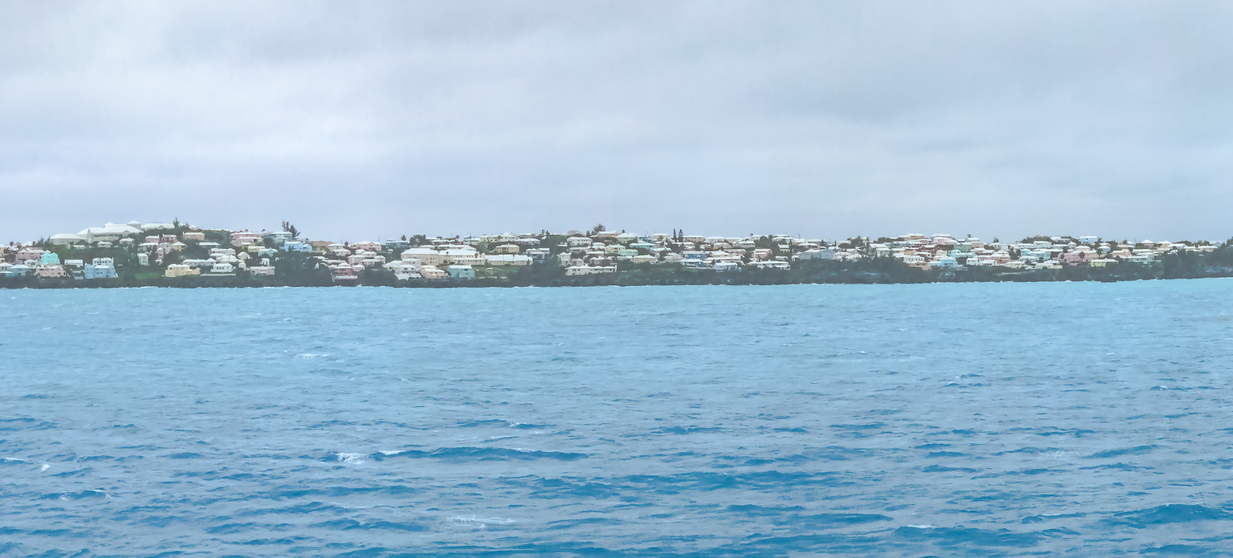
After two pretty rough days at sea, we’re now docked in the Royal Naval Dockyards in Bermuda.  We’ll be docked here for about 36 hours, before we set off across the Atlantic Ocean to the Azores. The island of Bermuda is 665 nautical miles to Cape Hatteras (the closest land to the island), and the next nearest land is Nova Scotia. If you drilled through the Earth to the opposite side, you would come out directly opposite Perth, Australia.

Photo Credit to Michael Scott

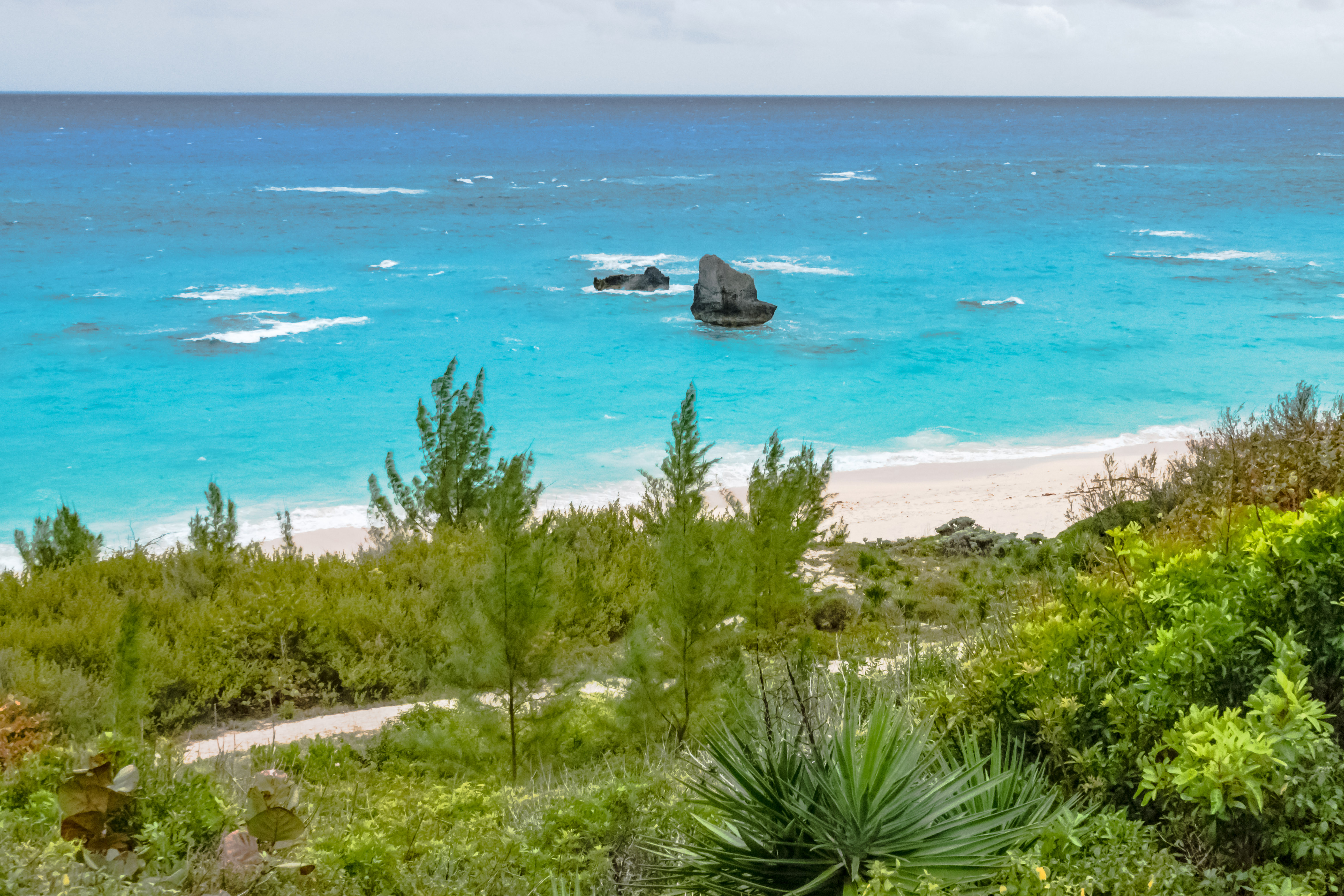
Bermuda sits on an extinct volcano, situated about 100 feet below the surface. A reef grew on it until it pushed out of the sea, when it was destroyed by waves, which limestone and created sand dunes, and solidified over time. Not much grows here naturally, but over the centuries, people have transported countless varieties of flora to the islands, and it is a green and flowering oasis.  The only tree which is endemic is a kind of twisted cypress, which is not much good for building anything.

Bermuda is a self-governing British Overseas Territory, and is the largest left in the former British Empire. Although the Governor is appointed by the Queen, the main governing authority in Bermuda is in its Parliamentary system, which has two houses. Parliament meets in Session House in the capital of Hamilton, which is about a 45 minute drive from here.

The Bermudian currency is the Bermudian dollar, which is pegged exactly to the US dollar. In fact, most merchants readily accept US currency, and will actually give change in US currency as well.  Which is a pity, as the Bermudian currency is some of the prettiest we’ve ever seen!

Bermuda consists of 181 islands and islets, which are really the tops of low forming volcanoes near the Sargasso Sea upon which coral has grown for millennia.  The total land mass is about 20 square miles. The population of Bermuda is pegged at 71,000 people, but only about 1,000 of those are permanent residents.

The islands enjoy a subtropical climate, which encourages a riotous profusion of flowers and flowering bushes to bloom here. However, it’s still early in the season to enjoy all that bounty, as it is blowing hard today, and raining off and on.

As you might guess for a country consisting of so many tiny islands, in many cases, the best form of transportation is often by boat. From where we are moored, the most expeditious way to get to Hamilton is a ferry, which only takes about half an hour. The bus system offers day pass, and you can use the No. 7 or 8 bus to Hamilton, but it takes about an hour to get there. There is also a shuttle bus, which runs to Horseshoe Bay, and is one of the most iconic tourist sites with its pink sand beach. The islanders actively discourage car ownership and use, and the roads are narrow and basic.  There is a 75% import tax for cars with a value under $12,000; for car worth over $12,000, the import tax is 150% of the value. There are no cars for rent, but recently, the island has switched from renting mopeds to renting small, 2-seater enclosed boxes. Basically, they’re quad-style scooters with a cover. Jim and I didn’t try one, but we were tempted.

For our first activity of the day, Jim and I have signed up for a walking tour of the Royal Naval Dockyards with a local historian.  He was incredibly informative, but at times, it was like drinking from a firehose!  I hope I’ve captured enough of what he said to give some relvance to these pictures!

Bermuda was discovered by Juan de Bermúdez in 1608. At that time, there were no inhabitants of the island. English colonial activity began in 1612 in St. George’s parish, which is near to the Dockyard.  The settlement in St. George’s is the oldest continuously inhabited English colony in the New World.

The Royal Naval Dockyard is built on Ireland Island. It was originally settled by John Ireland, who wanted to farm sugar cane and tobacco, but they don’t grow here. Instead, he grew food and harvested birds, fish and turtles for Jamestown colony in the Americas. He went inland, and started farming in what is now known as Somerset Parish. However, by 1650, the land was depleted from intensive farming efforts, and many of the meat and fish sources had been depleted as well, so further development of the island was abandoned. 

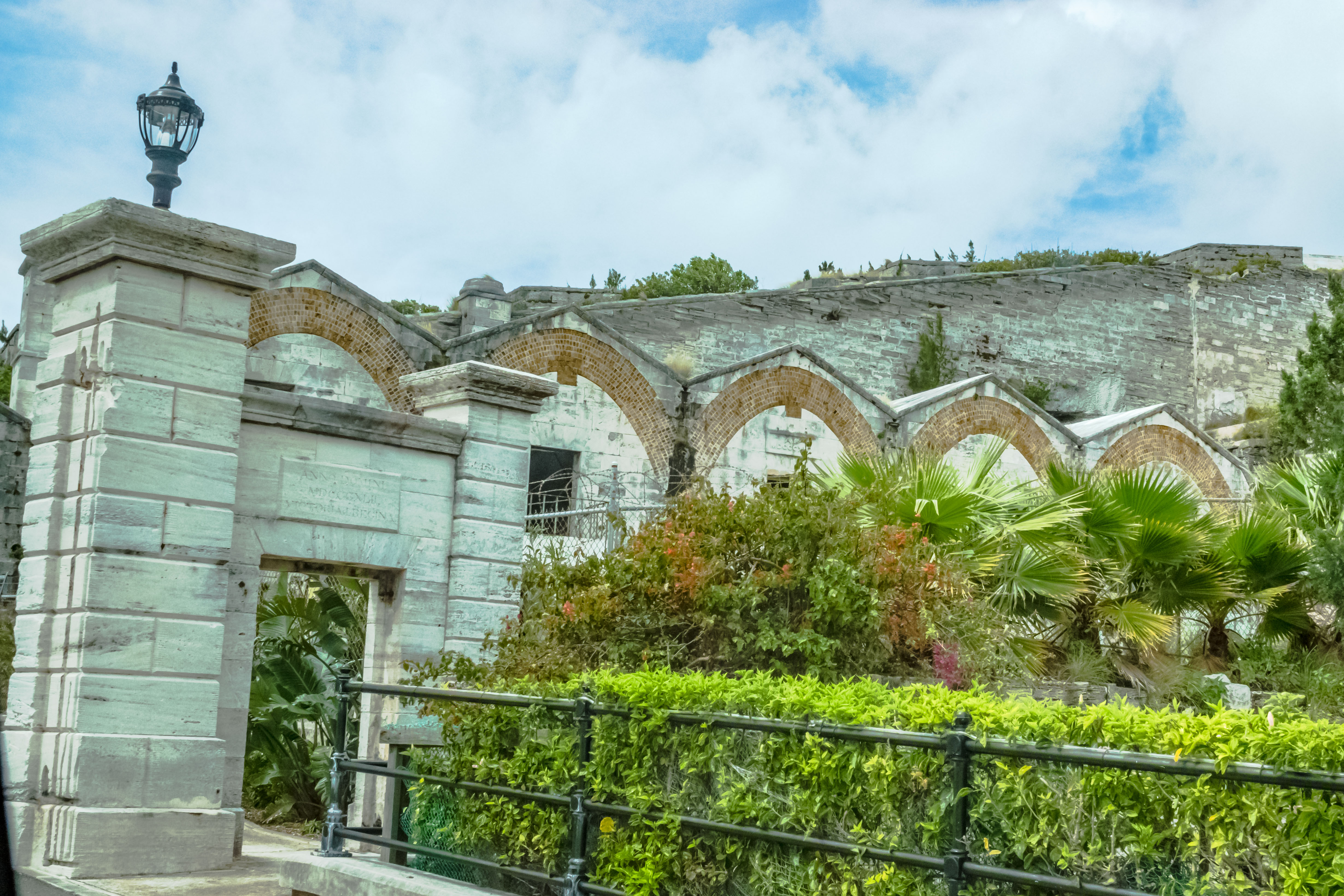
After American independence in 1783, the British navy decided they needed to put a resupply base here since the former colonies were no longer available. The first buildings were made of wood imported from Canada, and built by slave labor.  Given the gale-force winds prevalent in the islands, those buildings didn’t last long, and the British began to build out of coral blocks (limestone), which is so prevalent on the islands. In fact, in the area where the fort and the storage houses were built, there was originally a mound of limestone, which was cut down to make the blocks for the buildings. All of stone buildings from 1820s are still standing here in the Dockyard. After Britain outlawed slavery in 1834, the Navy used convict labor to build the remaining installations in the Dockyard. Most of those convicts were poor Irish people whose greatest crime was to complain about the British allowing the Irish to starve during the Potato Famine, and who were convicted of treason.

Our two planned activities for the day include a walking tour of the Royal Naval Dockyards, and then a van tour to Hamilton and around the southern tip of the island where some of the most famous beaches are located. 

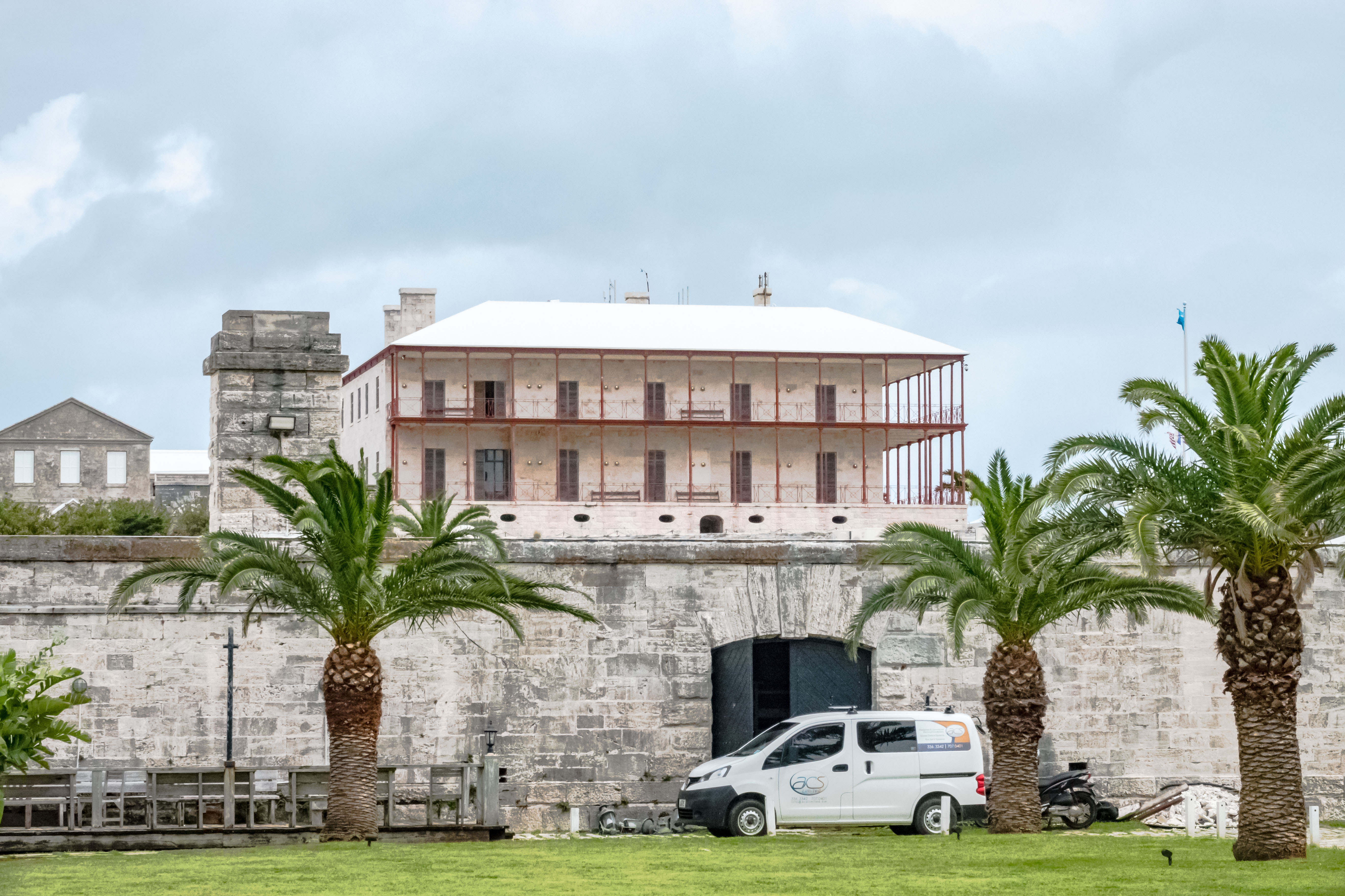
The first thing we can see from our ship is the walled fortress enclosing the Dockyards. In the beginning, when ships pulled in to Bermuda for re-provisioning and repairs, they were required to unload all their gunpowder and store it securely in the Keep.  There were separate storage vaults located further in to the Dockyards where ships could procure additional stores of gunpowder to restock their ships.

The walls of the Fort carved out of limestone
Limestone walls
Where the gunpowder was kept safe

The  Dockyard was never attacked.  We walked into the huge area in the center called the Victualling Yard, where all of the preserved food stores were stored. Bermuda imported salt from Turks and Caicos to use for packing  meat  and fish. In the later years, when the whalers fished off coast in March, those ships also put into Bermuda to process their catch and re-provision.

The Victualling Yard
The Storehouses

From the Victualling Yard, you can see the Governor’s Palace, which was the first home in the world built with a cast iron frame. The Royal Navy decided to build it as a test case, at a cost the equivalent of $10,000,000 today.

The Governor’s Palace
See the cast iron framework?

We then walked over to the actual Dockyard, which faces the bay. Nova Scotia granite was imported to make capstones in dockyards, because a more solid base material was needed to hold the winches which careened the ships on their sides. Most ships were repaired by careening on the shore in the dockyards bay. This worked until steamships replaced sailing ships in the 1880s. Although the steamships were around earlier, they were adopted late here, because while Bermuda has plenty of wind, there was no coal here.

The shore where ships were careened and repaired

On an interesting historical note to our American readers, a fleet of 9 ships were prepared here for the Battle of Bladensburg in the War of 1812, which led to the burning of Washington, D.C. The British soldiers who made that attack salvaged a set of Dolly Madison’s china, which is on display in a museum here.

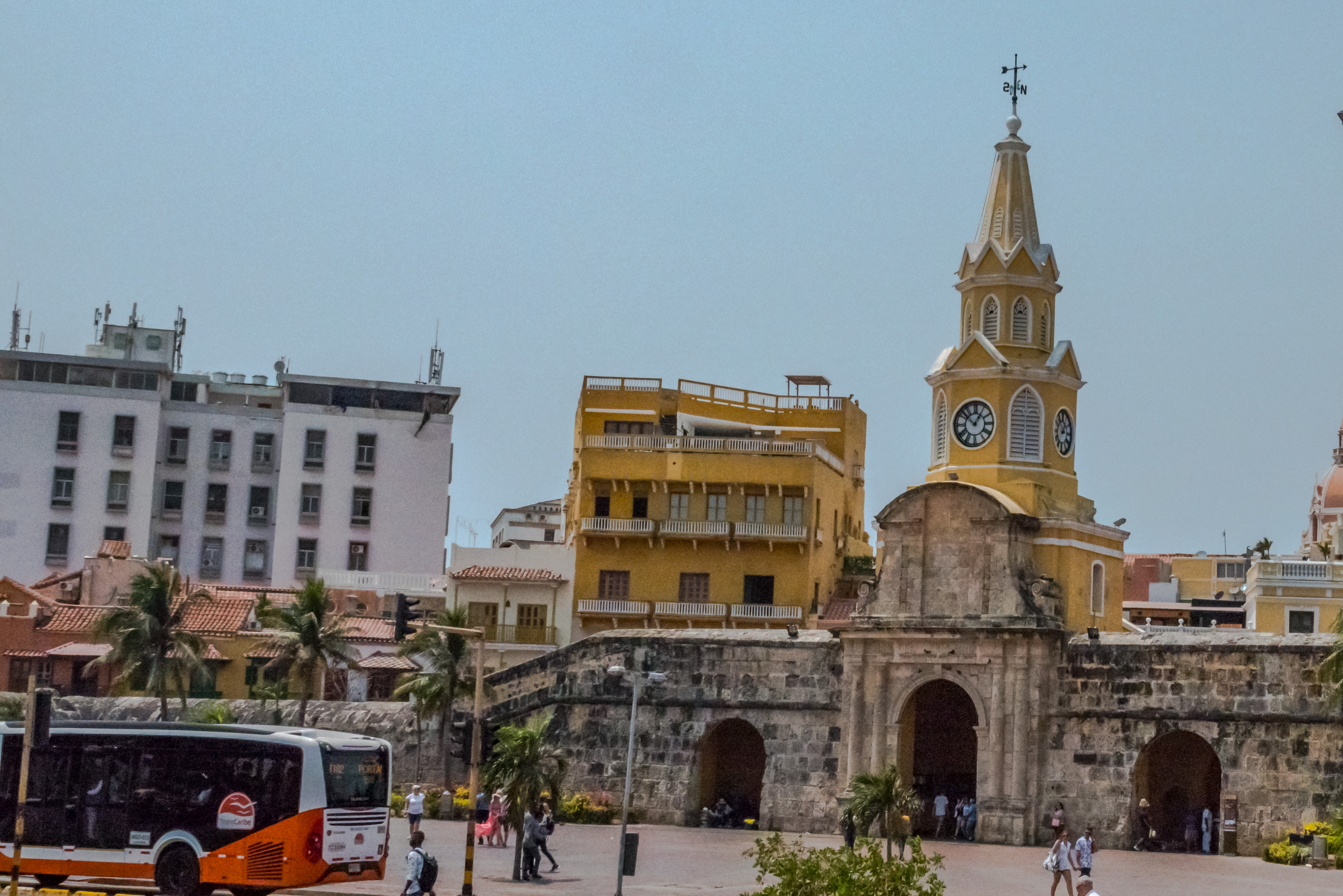
We finished our tour with a look at the storehouses and barracks. The five shops in the back are where where masts we made for the ships out of imported wood. Those with the curved roofs were the gunpowder stores. The Great Eastern Storehouse has the clock tower, and held everything necessary to repair a ship, but it all had to be shipped in from England and Canada.  From 1857 to 2017, all four clocks had a different time. The clocks were repaired in time for the America’s Cup yacht race in 2017. The towers also noted the high and low tides each day.  The base closed in early 1950s, but by the 1970s, the Bermudean government began rehabbing dockyards as a tourist attraction.

The Great Eastern Storehouse
The gunpowder supply houses

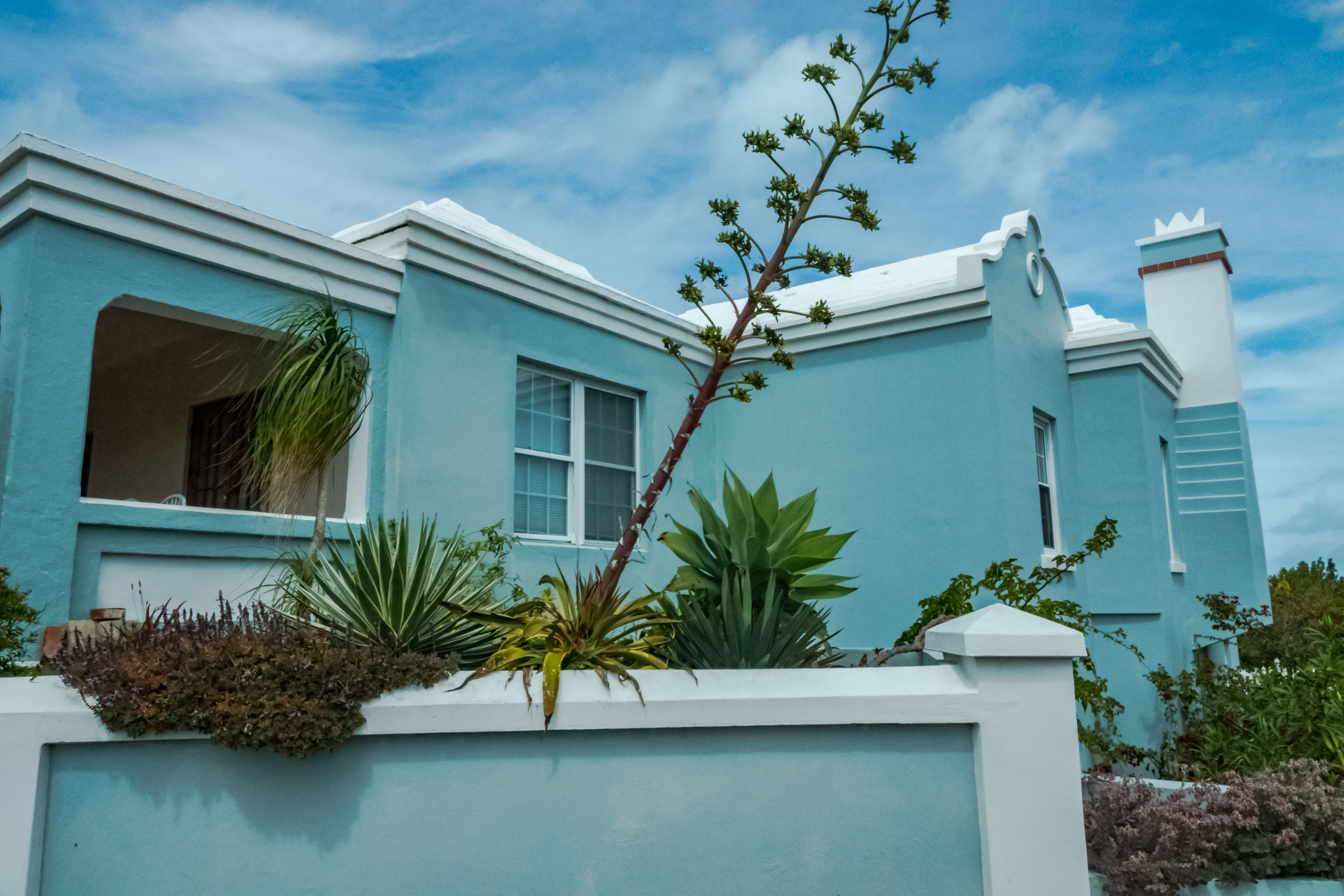
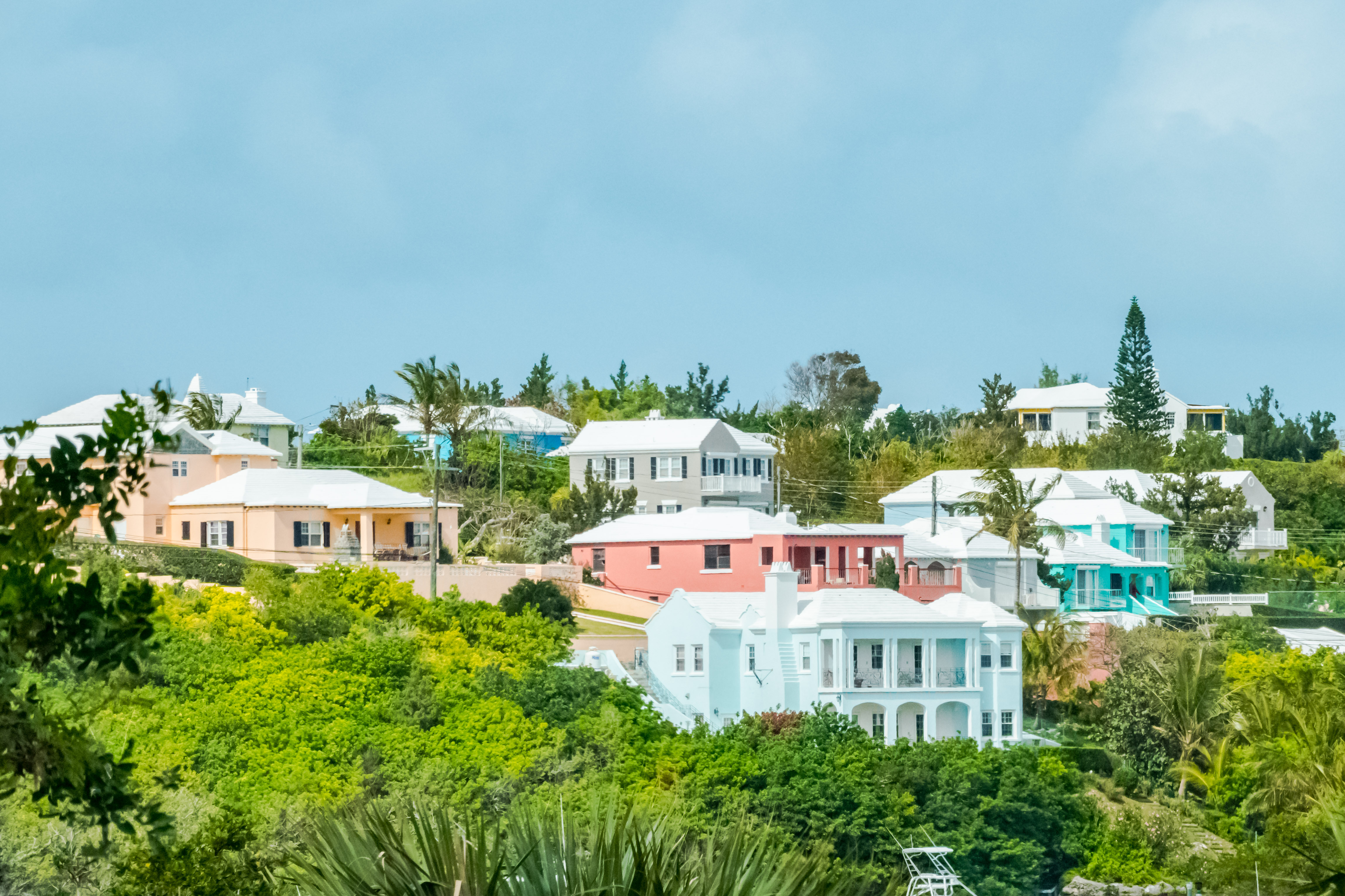
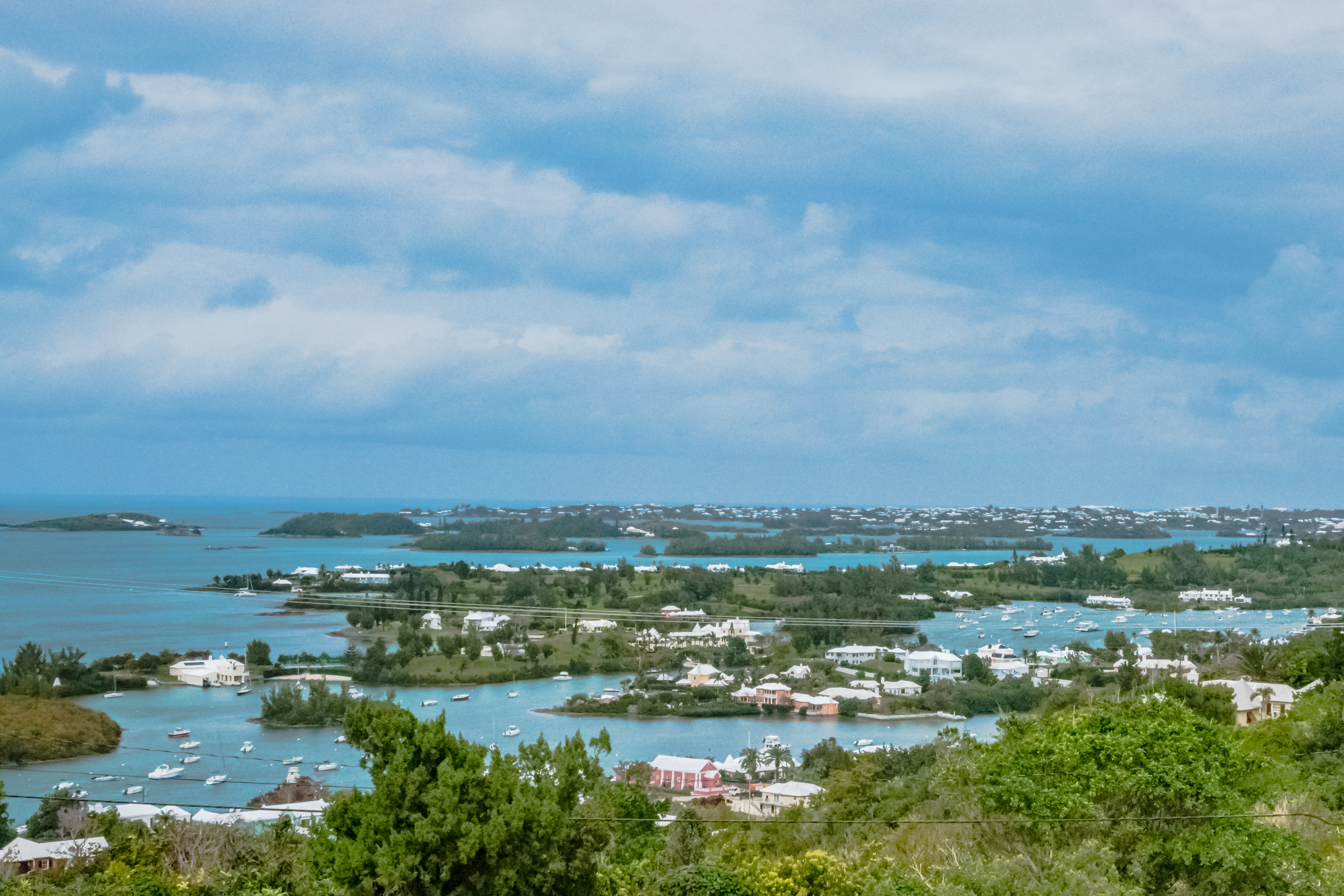
In the afternoon, we drove off on our tour of the island highlights. We drove along Harbour Drive, which is considered one of the most beautiful drives in the world. The widest point on the island is 1.2 miles wide, and the locals like to say that you’re never more that 3 minutes from the ocean.All of the houses are stunningly picturesque! They’re all painted in Easter egg colors, and each has a terraced white roof.

The island’s water supply depends on roof-captured water. If you running out of water, it costs $90 per 900 gallons to buy water. Although some people have wells, well water is not used for drinking. The collection pipes must be lined with lime, because the all sewer on the island is via septic tanks.

See how the pipes collect water from the roofs?

The widest point on the island is 1.2 miles wide, and the locals like to say that you’re never more that 3 minutes from the ocean. drove first through the town of Somerset, where we drove over a drawbridge which is the smallest drawbridge in the world. It’s just wide enough to allow the mast of a sailboat to pass through. 

Somerset Bridge: World’s smallest drawbridge

There are 9 parishes in Bermuda. Today, we will visit only 3: Southhampton, Pembroke and Hamilton. There used to be old US naval  and Air Force bases here, but they were decommissioned and abandoned in the 1990s.  While education through high school is mandatory, there is only a junior college on island. To attend university, young people must go to the mainland. As we pulled into Hamilton, we could see Sessions House with the clock tower.  Our guide explained that in its parliamentary form of government, the Premier runs everything, while the  Governor appointed by the Queen is merely a figurehead. There are 2 political parties, with the Labour Party currently in power. There are 11 senators and 36 members of Parliament for an island of 22 square miles.

Sessions House. The Parliament meets on the upper floor and the Supreme Court meets on the ground floor.
Front Street in Hamilton
Hamilton Harbour
Hamilton Cathedral-no building on the island is allowed to have a taller roof than the Cathedral’s

After briefly stopping in Hamilton and walking along the harbor, we continued our drive down along the southern shore.  Our first stop was to photograph the famed Horseshoe Beach with its pink sand. I can tell you that there weren’t many people there on this cold and wet spring day!  

Horseshoe Bay

Our final stop for the day was at Gibbs Hill Lighthouse, which was built of cast iron in 1847. Queen Elizabeth visited here and proclaimed that the view was “fit for a Queen!” Then we headed back to the ship.

Gibbs Hill Lighthouse
The Queen’s View

March 29th:

Today was a wet and wild day. Jim and I had planned to do a boat excursion whish would have taken us around some of the more scenic areas of the island, and then take the island ferry to the Aquarium and Zoo, which is supposed to be very good. However, we awoke to huge whitecaps just here in the harbor, so we decided it wouldn’t be too bright to go out on the water in small boats.  Instead, Jim decided to go to the Bermuda National Museum housed in the old Keep in the Dockyards.  I walked around the Dockyards and visited then craftwork collaborative run by local artists, and the glass blowing shop, which is conveniently housed in the same building as the shop which makes traditional Bermudean rum cakes in several flavors.

The real excitement of the day, however, was watching our Captain try to maneuver the ship out of port. The wind was blowing at about 40 knots straight at the port side of the ship, which effectively had the ship pinned to dock on the starboard side. The Captain prevailed, although it looked like he used every ounce of thrusting power he had aboard, and a couple of tugboats stayed close until it was sure that we were going to clear the dock. In the process, it looked like we kicked up half the sand on the bottom of the bay!  We then had a lovely sail out through the islands into the maelstrom of the Atlantic. We’ll talk to you again when we hit the island of Faial, in the Azores in four days.

Those whitecaps out there are what we are sailing into
The waves in the harbor
All the sand we kicked up pulling away from the dock!
Bye Bye, Bermuda!

My Miami

Mar. 25, 2019:

Yesterday was a sea day, as the Explorer steamed towards Miami. Jim and I filled some of the time by taking a cooking class yesterday in Regent’s Culinary Arts Center onboard. Wow, is this a fun kitchen set up!  Not only are the instructors fabulous, but the kitchen crew sets up your mise en place for each dish and thencleans up after you as you cook!  Our class yesterday was called “Perfectly Sauced and Tossed”. In addition to getting some really good recipes, we also learned some techniques I know we’ll use back home.

Today, most of our fellow passengers left the ship (except for 67 of us traveling onward), and that means the ship is in a turmoil all morning. The rest of us actually had to leave the ship briefly, to check in with Customs at the dock. I decided to use the opportunity to find a nail salon, and get a mani pedi at a reasonable price. As you can see from the picture, our ship is docked at the main cruise terminal in Miami harbor on Dodge Island.  From there, it is a short drive over the bridge to downtown Miami. Actually, the nail salon I found online was on 8thStreet (Calle Ocho) in what is traditionally Miami’s little Havana neighborhood.  True to form, all the salon technicians primarily spoke Spanish, which wasn’t a problem.  The salon, called Neo Nails, was very nice and clean, and the service very good. Thus restored, I returned to the ship.

After getting everyone aboard and going through the obligatory lifeboat drill, we had a great sail away at sunset. Next stop in two days’ time is Bermuda.

It’s A Grand Day for Diving in Grand Cayman

March 23, 2019:

Welcome to George Town, Grand Cayman! There are three main islands making up this autonomous British Overseas Territory; Grand Cayman, Cayman Brac and Little Cayman. The islands cover about 102 square miles, and have a population of just under 60,000 people, which makes it the second largest British Overseas Territory (after Bermuda).  There is no historical record of indigenous people inhabiting the islands, but over the years, pirates and bankers, among others, have inhabited the islands. In fact, financial services are the main industry in the islands, and there are more companies registered in the Caymans than there are people.  There are innumerable leisure time activities to be enjoyed here, and both the fishing and diving are excellent. So good, in fact, that this concludes our post on the islands, as Jim and I are off to go scuba diving.  We’ll talk to you again from Miami, where part one of this cruise will end.

Cartagena: Jewel of the Caribbean!

March 21, 2019:

This is return trip to Cartagena for us, and so we resolved just to immerse ourselves in the colors , sights, and flavors of this beautifully restored Colonial town. For a more in-depth discussion, you can check out the Gringos earlier post on the city from 2015 :https://vayacongringos.wordpress.com/2015/05/15/cartagena-de-los-indies/ and from 2017: https://vayacongringos.wordpress.com/2017/04/

View of La Popa Monastery from our ship

Upon arriving in Cartagena, we got aboard one of the Hop On, Hop Off busses here, which offer a great introduction to the various neighborhoods in Cartagena. The ship is docked in the cruise port, which is right in front of the very popular Manga neighborhood (named for all the mango trees there).

The city walls with the modern day buildings in Bocagrande behind them

La Puerta del Reloj (the entrance/ gate at the clock tower)

Then we drove through the Gethsemi neighborhood, which used to be the poor part of town outside the city walls where slaves and mixed race people (non-Europeans) lived. It has since become a very hip area, with lots of shops, restaurants and live music.

Looking towards El Castilo de San Felipe de Barajas

Then, the bus took us towards the Castle of San Felipe de Barajas, which was never taken by pirates, although the old city itself fell. There are always brightly dressed fruit vendor ladies here who will take a picture with you for a couple of dollars.

The Fruit seller ladies by the Fort.
Flag of Colombia

The bus route took us along the back side of the city fortifications on the sea side of the old town facing the water. Usually, young people play soccer on the playing fields in front of the fortifications. Jim and I really like walking up on the ramparts here, mostly because it is the best place in the closed old city to get a breeze. In the evenings, young lovers watch the sunsets together from the ramparts.

Up on the ramparts

We entered the old city from one of the ports on the seward side and began our visit with a couple of stops at Las Bovedas. This is a series of mostly touristic shops built into what used to be the prisons in the city fortifications. However, there was another huge cruise ship in port today, so we quickly abandoned that attempt, and then walked further into the old city.

Jim with the fruit vendors

Our plan was then to have lunch at one of our favorite places in Cartagena, La Cevechería. However, as you can see, even that was teeming with people.  

La Cevechería

On to Plan B.  After buying a replacement “Panama Hat” (made in Equador) from one of the ubiquitous street vendors,  Jim and I retreated into the air-conditioned sanctuary of a café called Crepes and Waffles. Not only do they have fabulous ice creams (as well as a full menu of salads, sandwiches, wine and beer), but the café is operated as a sort of social redemption project, particularly as a way of training women to have valuable job skills.

We were pretty much done fighting the crowds in the old town by then, so Jim and I left out the front of the old city past the Aduana building (the old customs house) and out the clock tower gate.  Conveniently, the pick up location for the Hop On, Hop Off bus was right across the street. One of the highlights of the day was yet to come, however.

Farewell to the Clock Tower

We rode the Hop On, Hop Off bus back to the the cruise terminal. One of the great things about Cartagena is that it has an AWESOME cruise terminal. After you get off your ship, you enter a mini wildlife park with lots of domesticated tropical birds, and some aviaries where you can walk among the non-domesticated ones. There is a lovely gift shop here, and also a very nice coffee shop where you can enjoy your coffee in a jungle-like environment.  We had a ton of fun just photographing the birds and the anteaters.

I’m not sure which kind of a toucan this is; possibly a toucanette
Smooth-billed Ani
????
Mealy Parrot
Blue and Yellow Macaw
Blue & Yellow Macaw with a Red and Green Macaw
Chestnut-fronted Macaw with a Blue and Yellow Macaw
Anteater
Lazy Anteater

We had a lovely sail away from Cartagena, and now we will have a day at sea before we reach our final port of the cruise, Georgetown, Grand Cayman.

Transiting The Panama Canal

March 20, 2019:

The day of our Panama Canal transit is finally here!  We just wish Charlotte could have been here to share it with us!

Early this morning (as in, before dawn), we arrived at the pilot station out in the bay and took on our pilot to guide us through the Panama Canal. We will be transiting through the old set of locks, which have now been in operation over 100 years. They remain one of the greatest engineering marvels around, and the new locks are pretty amazing, too!

Coming into the Canal from the Pacific side, approaching the Bridge of the Americas
Passing under the Bridge of the Americas
Bridge of the Americas from our stern.
Looking at the entrance to the Mira Flores Locks
Ancón Hill
A post-Panamax freighter entering the Cocoli locks
View of the Panama City skyline behind Ancón Hill
Sunrise

Jim and I went up to the stern, and had breakfast while we watched our transit through the Miraflores locks. The entire transit takes about eight hours, with each set of locks taking approximately 30-45 minutes to fill (or empty). Truthfully, at time it seems like watching paint dry, so I tried to keep my eyes open for the wildlife we might see in passing.

In a nutshell, the engineering challenge in building this canal was to raise each boat about 85 feet above sea level over a system of locks and a man made lake, and then lower the boat back down to sea level at the Caribbean side of Panama. More specifically, we will come in from the Pacific Ocean and enter the first set of two locks at Miraflores, sail into Miraflores Lake, then through 1 lock at Pedro Miguel, cross Continental Divide, motor through the Culebra (aka Gailliard) Cut, under the Centennial Bridge, sail across Gatún Lake, and then lower the ship back down to sea level through the three Gatún locks. By contrast, the new “third channel” of the Canal (which was just completed in 2016) uses two new sets of locks; on the Pacific side, the Cocoli Locks (with 3 steps), and the Agua Clara locks, on the Atlantic side (also with three locks).  The new channel can handle the larger “post-Panamax” ships, which are larger than 106 feet wide, 965 feet long, and 39 feet deep. Jim and I were fortunate enough to visit Panamá twice while these new locks were being built, and the engineering challenges were truly mind-blowing!

Credit to Michael Scott, OBE
Great white egret
Black vultures

For a great history of the building of the Canal, I highly recommend David McCulloch’s book, The Path Between the Seas. However, in a nutshell, the history of the building of the Canal is as follows.  In the mid 1800s, after the discovery of gold in California, the world became frantic for a more rapid way to make it to California from the East Coast and Europe. For a time, eager gold prospectors made a trans-Panama crossing of Central America, which required a dangerous overland route through dense tropical forests teeming with diseases.  In the 1850s, a railway was built between Panama City and Colon, which allowed for a more direct and quicker route across the Isthmus of Panama, but was still disease ridden. In the late 1870s, the French, under the leadership of Ferdinand du Lesseps (the builder of the Suez Canal) came up with a plan to build an overland canal through the Continental Divide in the Isthmus of Panama. His plan depended on blasting out a canal through over 100 meters of rock.  The French sponsored the Panama Canal Company. In 1871, construction on the canal began, at great effort, expense and loss of life. The excavation efforts kept collapsing, and deaths from illnesses such as yellow fever and cholera were rampant. By 1889, the French enterprise was bankrupt, and over 22,000 people had died in the attempt.  It was not until 1904, under the urging of the US President Teddy Roosevelt that the effort was resuscitated. The Americans supported the Panamanians rebellion from what was then known as the Republic of New Granada (modern day Colombia). Immediately after the successful rebellion (supported by US gunboats), the new government of Panamá signed a 99-year lease with the Americans for the construction and operation of the Panama Canal. Construction started immediately, and the first ship (the S.S. Ancón) sailed through the Canal in 1914. 

The Canal operated under that lease under 1979, when President Jimmy Carter signed an agreement with the Panamanians to return control to them in 1999. The Panamanians have operated it successfully since that time. Given the advent of ships larger than the dimensions of the original Canal, in about 2010, the Panamanians embarked upon a massive project to add a third “lane” to the canal to permit passage of the new larger ships. In 2016, that new lane was completed.

Entering the first set of locks at Miraflores, hooking up with our “mules (small locomotives which stabilize the ship side to side within the locks)
Female Magnificent Frigate floating on the ship’s updraft
The first lock closing behind our ship

There is a webcam on the side of the visitor center at the Miraflores locks; look at PanCanal.com to see still photos of each ship passing which refreshes every 30 seconds.

The Miraflores Visitor Center
Watching the first lock fill
A ship going through the locks in the channel next to us

Exiting out into Miraflores Lake
The Pedro Miguel Locks
Exiting the Pedro Miguel locks, we approach the Centennial Bridge over the gap cut across the Continental Divide.
As you can see, the cut is an awesome engineering feat, cutting through more than 100 feet of rock, and requiring massive bench cuts.
Passing under the Centennial Bridge
The Culebra (aka Gaillard) Cut
Rock anchors required to hold the hillside in place.
Passing out into Gatún Lake

Gatun Lake is 21 miles long, and typically takes one and half to two hours to cross it. It is also the first time we start to see ship traffic coming from the opposite direction. The lake and its islands are a giant wildlife sanctuary area, and I’m particularly keen to see if we can see any of the capuchin monkeys which live on the islands.

Not a monkey, but a crocodile at least
The Panama railway crossing the Charges River
The Observation tower in the Soberanes National Park accessed via a gondola
Looking back up into the headwaters of the Chagres River
View of the new Agua Clara locks in the distance
entering the Gatún locks
View from the ship’s bridge looking towards the Caribbean
Passing out into the Caribbean under the nearly complete Atlantic Bridge
Crocodile sunbathing
Setting sail for Cartagena!

Camera also on building at Agua Clara locks

Puttering Around in Punta Arenas

March 18, 2019:

Late this morning we docked in the port of Punta Arenas, Costa Rica. We had a small band welcoming our arrival, but Jim and I have an excursion which leaves later today.  Our plan is to take a drive down the coast about 45 minutes, where we have three main activities: a demonstration of some Costa Rican dances by the teenagers at a community center; a ride on a historical train, and then a visit to the mangrove forests where we will hopefully see some of the famous local wildlife.

Coming Into Costa Rica
Brown Pelicans
Band welcoming us
Beach Club

As usual, the bus ride gave us an opportunity to learn some about the country we are visiting, which always helps me share that information here. This is Jim and my second visit to Costa Rica, but we were really intrigued by this country on our first visit, and we are eager to learn more.

Costa Rica has a population of 5,000,000 people, and is about the size of West Virginia. Costa Ricans (or ticos/ticas, as they call themselves), are a very highly educated country with a literacy rate of 97%. Like the Nicaraguans, they have their own highly idiomatic greetings of “Pura Vida!”Strictly translated, it means “Pure Life”, but the Ticos use it as a greeting, an inquiry, a response, and a farewell. 

School from kindergarten through high school is mandatory, and paid for by the government, meaning the government provides the teacher, school and lunch, but parents provide everything else (uniforms, books and school supplies). High school is from classes 7-11; in the countryside, there is a grade 12, but it is vocational school, and largely aimed at rural students who do not want to go on the university.  The school day is only a half-day (5 hours), because virtually all of the schools run on a two track day (classes morning and afternoon). School system operates from February to  November.

Tico schoolchildren learn English from kindergarten, so virtually everyone you meet is fluent in English. Then, starting in 7th grade,there is a requirement to learn a third language. Until recently, that language was French, but since 2015, Mandarin has become the third language. Interestingly, the most popular profession is teaching, but the law, tourism, and computer technology are also very popular professions.

The currency is the Costa Rican Colón, and the current exchange rate is about  600 Colóns to $1. The national beer is the Imperial. The country has no oil, so it is imported and refined on Caribbean coast. The price of gasoline is fixed throughout country, and  currently costs about $4.50-5.00 per gallon. However, a gallon of diesel is currently $2.50-3.00 because it is subsidized by the government in order to keep the cost of staples which are shipped from being too expensive.

This gets us into a sensitive political discussion. Most of the people in Costa Rica believe there is a serious problem with illegal immigration from Nicaragua.  Costa Rica is an attractive location for the Nicaraguans both to escape the periodic political instability there, and because the benefits guaranteed to Costa Rican citizens is high, leading to a much better quality of life here.  For example, in addition to the superior education system here, Costa Ricans enjoy both a good national health system, and a national pension system. Both are paid for by Costa Ricans in the form of a 9% annual income tax on all earnings, and the Costa Rican government shares the cost in the form of a peace dividend because they abolished their armed forces in 1965.

Generally, the Ticos believe that the influx of Nicaraguans contributes to the overcrowding problem in schools, a national unemployment rate of about 10%, and fraud in both the healthcare and pension systems. You can see why there is an influx; while minimum wage in Nicaragua is about $750/month, in Costa Rica, the average teacher earns $1900-2100/month. However, our guide freely acknowledged that the Nicaraguans seemed to be doing the types of work that better educated Ticos weren’t willing to do, and that despite the long wait times in the healthcare system, when his sister needed very complex heart surgery, she was able to get it from a highly trained specialist at no cost to the family.

Now on to our experiences. Our first stop was at a seaside village called Linda Mar. There, we were entertained by some teenagers at the community center, who demonstrated several types of Costa Rican dances, including something called Swing Criollo, an Afro Caribbean dance, and a Salsa dance. Then it was time for them to attempt to teach us the salsa dance. It was fun, if a little too hot to be doing anything that energetic.

Traditional local crafts, including the Costa Rican painted carts called carretas

Then, it was time for our train ride on a historical train. The train system here was damaged irreparably by an earthquake in 1992. Now only short lengths of the system have been restored, mostly around coast for tourist activities, and in the capital. Candidly, we were a little disappointed by this activity, which we had understood was going to be going through an area in the country where we thought we might have some chances to see wildlife. Instead, what we found was that along the train lines, there were a series of shanty houses which had been erected by the Nicaraguan immigrants.  As we drove past on the train, the children and their parents were very friendly, but not the sort of excursion we thought we would be having.

Then we drove to what Jim and I think was the highlight of the excursion, our boat ride through the mangrove forests on a river-way close to the coast.  Almost immediately upon arrival at the boats, we were greeted by the loud caws of the iconic scarlet macaw!  Wow! They are really some gorgeous birds, and we were not able to spot any in the wild on our last trip. Then a whole troop of white-faced capuchin monkeys began an elaborate aerial ballet through the tops of the trees surrounding the launch site. The little suckers are really fast, so none of my pictures are very good.

Scarlet Macaws
White-faced Capuchin

This is a really interesting wetlands area with the roots of the mangroves creating a shelter for all sorts of small creatures.  The water is brackish and subject to tidal influences, so in addition to the birds and monkeys, small mammals and snakes you might expect, there are also salt water crocodiles here. Of course, everyone immediately started looking for them.  However, I was really captivated by all the wetland birds!  We saw several types of herons and egrets, including a tiger heron, but the thick branches everywhere really prevented me from capturing them with my camera. However, we did see one Little Blue Heron, who obligingly posed for the camera. And for the birders aboard, there was a rare sighting of a Pygmy American Kingfisher, which was just a stunningly beautiful bird.  We also saw the local version of a raccoon. Sadly, though, the closest we got to seeing a crocodile was the view we had of the really large claw marks he had left in the mud.

Little Blue Heron
Pygmy American Kingfisher
Raccoon
Crocodile tracks

On our drive back along the coast, we were treated to one of the most stunning sunsets I have ever seen! Enjoy the shots and we’ll be back on Wednesday, March 20thfor our transit through the Panama Canal!

And Now, Nicaragua!

March 17, 2019:

Happy St. Patrick’s Day, dear Readers!  This morning, we pulled into the port of Corinto on the Pacific Coast of Nicaragua. Jim and I have never been here, and we are eager to explore.

We had a fabulous welcome in Corinto

As we came into port this morning, you could see the whole chain of volcanoes along the Continental Divide, which have so shaped Nicaragua’s history.  Our explorations will take us about two hours inland to visit the abandoned township of León Viejo (Old Leon), which was abandoned after a catastrophic eruption of volcano Momotombo in 1609. We will also see the “new” town of León Nuevo, which was established in 1610 after León Viejo was abandoned.  We’re very keen to learn more about the colonial period, as well as the most recent political history of Nicaragua. This is of particular interest to me as my major area of study in college was Latin American history, and some of the most important recent happenings here took place while I was in college.

It seemed like all the kids in Corinto turned out to greet us

Since we had plenty of time on the bus, our very informative guide, Elvis (yes, that is his real name), had plenty of time to educate us about his country.  Nahuatl is the native Mayan language. The standard greeting in Nicaragua is “Dea Ca Chimba!”, which is both a question and a response meaning, “I’m feeling great!”

The Nicaraguan flag is blue and white with an equilateral triangle in the center featuring mountains and lakes. In fact, Nicaragua is known as the “Tierra del Lagos y Montañas” (land of lakes and mountains), and 10% of area of country is covered in lakes. The two largest are Lake Nicaragua and Lake Managua, and León Viejo was founded on the shores of Lake Nicaragua.  The capital city is now Managua (about three hours away), although it used to be León during the colonial period.

As we drive, we can see the whole range of volcanoes stretching before us. There are 27 volcanoes across 300 km in length of the country. Nicaragua also has 420 km. of the Pan-American highway stretching through it. The highest volcano is San Cristobal, which we see first. In our travels today, we will also see volcanoes Casitas, Talica, Cerro Negro, and Momotombo. The last eruption of Momotombo in 2015

In 1972, the volcanic eruption of another volcano caused a 7.2 magnitude earthquake which destroyed 90% of Managua. The famous ballplayer, Roberto Clemente, died bringing aid to the victims.

Nicaragua usually gets 450-750 mm of rain over its 6 month annual rainy season. However, in 1998, there was a huge Pacific hurricane, called Mitch, during which Nicaragua got one year’s rain just during that storm. The storm caused the Casitas volcano to collapse in a huge landslide, taking with it all the little houses built on its slopes for which it was named. The maximum temperatures reach 41C in Nicaragua, and it feels like it is trying to reach that temperature today. In reality, I think it topped out at about 100 degrees F. Rainy season is April to October, and March is considered the beginning of summer. 

Nicaragua gained its independence in 1821.  Today, it is one of 7 countries in Central America. However, for a brief period in the early twentieth century, it was part of a federation with other Central American states. The money is the Córdoba, currently valued at 31 to the Dollar (i.e., 100 Córdobas=$3). About 85% of the country is Catholic.

Elvis told us that Nicaragua has the best roads in Central American, and based on what we’ve seen in Guatemala and Costa Rica, he may not be exaggerating by much! The roads and many other social services are paid for by a national VAT tax, which used to be 10%, but is now 25%. It also pays for the education system in which education is mandatory, through high school, and starts at age 7. Exit exams are administered after high school, and university is free if your scores are high enough. The scores also determine which career you get to go into. For example, you need a score of about 98% correct to be able to enter the law studies program.

Today, about 80 % of the Nicaraguan economy comes from agriculture, consisting mostly of peanut, sugarcane, and cattle production. Its number 1 sport is baseball. Those of you about the Gringos’ age may remember the old Saturday Night Live skit with the Nicaraguan ball player who says “Bizeball been berry berry good to me!”  Nicaragua is roughly the same size as Wisconsin, and has a population of 6 million people. About 1.5 million of them live in Managua. There are 17 departments (“states”), of which, we visited two: Chinandagua and Santa Maria de Gracia. 

Of some interest to our future explorations on this trip, for a while in the 1800s, Nicaragua was seriously considered as the location for the construction of an overland route through Central America after gold was discovered in California in 1849.  Vanderbilt even got in on act, and looked at financing the route through Nicaragua.  However, as we all know, Panamá won out on that contest.

Our first stop this morning is at the excavated ruins of León Viejo. Interestingly, although a fair amount of information was collected by Spanish colonialists about this settlement on the shores of Lake Nicaragua, like Machu Picchu, after the settlement was abandoned, the jungle came in and disguised all signs of the settlement after it was abandoned.  It took another eruption of the volcano, Momotombo, to help explorers rediscover the ruins in the 20thCentury.

We were greeted at the entrance to this UNESCO World Heritage site by a troupe of dancers performing a Nicaraguan version of ballet folklorico. In this dance, the performers pantomime a bullfight.  It is interesting to see the slight variations of all these traditional Central American dances as we move from country to country.

As we move into the site, Elvis tells us about the remains of the various buildings in the settlement.  For the most part, all you can see are outlines of the foundations of these structures, as the roofs were burned off by the flying burning pieces of volcanic rock, and many of the buildings were buried in ash.  We stopped in our hike to admire a really lovely local bird, the Turquoise and Brown Moc Moc (a member of the kingfisher family), and for Elvis to tell us about the flora. In this case, he pointed out a blossoming oak with pink flowers, and a Cashew nut tree, whose stem is filled with water. He also told us about the Jicaró fruit, which is also filled with water, and when dried, the seeds dry out and become macarenas.  With it as hot and dry as it is in the Nicaraguan interior, we are all thinking frequently about water!

Map of the old settlement
Turquoise Brown Moc Moc
Cashew Nut (at bottom) with huge “stem” on top in orange

Probably the highlight of our walk came as we ascended the hill that once housed the sentry post for the settlement. From here, we have great views of Momotombo and Lake Nicaragua (and we got a really nice breeze, in addition!).

On the way back to the visitors’ center, we saw the ruins of a second church, Our Lady of La Merced, as well as those of the home of the richest man in León (Gonzalo Cano). This church played a pivotal role in the history of León Viejo, because its bishop was assassinated for complaining about the barbaric treatment of the indigenous peoples by the colonialists in town. Days after his murder, Momotombo erupted in 1609. The settlement was considered cursed because of the bishop’s  assassination, so the entire town relocated to León Nuevo in 1610. The excavations of this site finished in 1967.

Remains of Gonzalo Cano’s home

After a great traditional lunch in the old town, we drove to León Nuevo. Elvis explained to us that although the furthest south Mayan ruins have been found were in Copán, Honduras,  the cultural history of the Nicaraguan Mayans is artistic; not architectural. In their case, the primary art medium is pottery, and Nicaraguan Mayan pottery has been found dating back to 800 B.C. 

Léon Nuevo was first the capital of Nicaragua, and has a population of  250,000 people, making it the third largest city in Nicaragua. However, there was a traditional rivalry between the cities of León and Granada, so the current capital of Managua was picked as a compromise. Probably the premier site to explore in León Nuevo is the Cathedral, which is the largest in Central America.  

Architecturally, its form is a Latin Cross in shape, and it took 113 years to complete. There are over 150 people buried in catacombs, but our favorite part of the tour was the opportunity to climb to the roof of the Cathedral and look out over the town. Besides, you could catch the best of the afternoon breeze from there.  

We finished our tour with a brief stop in a cute little bar on the plaza, and then we boarded the busses for the hour and half ride back to the ship. Stay tuned, as tomorrow we dock in Puntarenas, Costa Rica, and we’re looking forward to seeing some of the flora and fauna there!

Guatemala, AKA Getting Charlotte Home

March 16, 2019:

Yesterday was a sea day, and unfortunately, Charlotte was feeling no better, and she decided she wanted to go home. So we set about working with the ship’s staff to figure out how to do that to keep her the most comfortable. The Regent team was able to find a flight leaving today from Guatemala City at 1:00 in the afternoon, and with one change of planes in Miami, would get her home to San Diego tonight. Many other options were considered and rejected, so we’ll spare you the machinations. Suffice it to say that with this option, we were able to hire a driver to take all three of us to the Guatemala City Airport, where we were able to get Charlotte provided with a wheelchair, get her luggage all checked in, and stay with her until her plane was called for boarding. In Miami, we were also able to get her a wheelchair assistant who took her through the immigration and customs process, and got her on the plane home where my sister, Janeen, will meet her.  Then Jim and I had the driver drive us the two hours back to the ship.  We immediately ordered adult beverages upon reboarding.

I took these photos from the car window enroute.

Street vendors in Guatemala City
A mural showing Guatemala Antigua. This is the closest we got to it.

Late tonight we got verification that Charlotte had safely made it home. Tomorrow we dock in Corinth, Nicaragua, and we will try to do a reset on this journey.

Ouch-Apulco!

March 14, 2019:

Disaster struck this morning!  As we were leaving the customs area in Acapulco, Charlotte missed her footing on some steps and fell into a metal handrail.  Unbeknownst to Jim and me at the time, she broke two ribs. Charlotte was pretty certain she had broken the ribs, but kept mum and gamely insisted on continuing on to catch our excursion to see the famous cliff divers and tour around town.

The band that greeted our ship playing mariachi music

Our first stop was in the old part of Acapulco known as La Quebrada (the “broken cliffs”) where the cliff divers perform daily, both every afternoon at 1:00 p.m., and every evening on the hour.  It is known as this because back in the Spanish colonial period, the Spaniards broke a pass through the hills to the harbor so the sailing ships would have enough wind to sail into the harbor where we docked.

However, because our cruise got in early, the divers made a special arrangement to do a performance just for our cruise passengers. The divers perform at the Mirador Hotel, and to get into the viewing area, you have to walk down at least 70 steps into the hotel (basically, down the side of the cliff) and another 70 steps back up. Charlotte gamely insisted on doing this.  She is one tough cookie!

We learned that the divers have a union, of which there are about 60 members, and the union provides a form of social security and disability for its members. Since diving from the heights of these cliffs causes permanent damage to the eyes and ears of the divers, most retire when they are about forty. The, the retired diver gets a pension in the form of a lump sum payment to start a business.

The show consisted of both watching several dives by a group of about seven divers, including several where they dove in pairs and one trio. Then we had a performance of ballet folklorico.

Then we returned to our bus, and by this time, it was pretty obvious Charlotte was in a lot of pain.  Fortunately, the rest of this tour consisted of a driving tour around the three areas of Acapulco: old Acapulco, new Acapulco, and the new high end development known as Acapulco Diamante. Along the way we saw various touristic sights such as the main Cathedral of Acapulco, which looks out on Bay of Acapulco,  and the Fort of San Diego built to protect the town from pirates. Both of the famous pirates, Sir Walter Raleigh and Sir Thomas  Cavendish attacked the city.

During our drive, we also learned quite a bit about the history of the town, starting with the arrival of the Spaniards in 1521. Because the Philippines were also colonized by Spain at the same time, and there was a fair amount of travel by the conquistadores between the two colonies, the people of Acapulco started trading with the Far East for silk and spices. The Spaniards also imported several crops from the Philippines, and adapted many of those crops for production in Mexico, such as coconut and mango plantations. 

Our tour then drove through the area of “new” Acapulco, along the beach known as La Condesa. The tour guide was fairly candid about the societal problems Mexico is experiencing because of the narco-traffickers.  For example, he noted that 20 years ago, Acapulco got about 400 cruise ships per year into its port, but that today, they will get only 49 because of the violence. 

The multi-story condo buildings along La Condesa beach

Today, most of the tourists are Mexican citizens, and they come mostly from Mexico City, which is 260 miles away, or 3 hours by new toll road.

We then drove up into the hills looking down on the harbor. Our guide showed us “Las Brisas”, which is one of the most exclusive hotels in Acapulco. The area surrounding it is also called Las Brisas, and  it is a very exclusive residential area. On one of the highest hills sits La Capilla de la Paz, a chapel built by the prominent Tourgette family as a memorial to their two sons who died in a plane crash.

Charlotte overlooking Condesa Beach from the heights of the Las Brisas area

Then we drove into Acapulco Diamanté, which our guide called “the future of Acapulco “.  We made a photo stop at Linda Vista overlooking this area.  It is now considered the most exclusive area for homes in the city. The harbor below is named Bahia de Puerto Marquez, and was named after Hernán Cortez, who was later named  a Marquis for his service to the Crown in discovering the New World.

Acapulco Diamante

The end of our drive took us by the Acapulco Princess. Back in the day,  Howard Hughes used to rent out top three floors so he could have his privacy. The main building was built to resemble the temples at Chichen Itza.

The Acapulco Princess

The tour over, we immediately hustled Charlotte into the medical center onboard the ship.  The Explorer has a very complete and modern suite of medical offices on board.  At the medical center, we were able to get Charlotte x-rayed. Although the x-rays were inconclusive, Dr. Jorge was pretty certain that Charlotte had fractured at least one rib.  He prescribed some pretty heavy duty pain meds, and also gave her a shot for the pain, which made her much more comfortable.

We got Charlotte settled into her cabin and made her as comfortable as possible, while Jim and I basically explored options for her to choose what she wanted to do.  Although we initially looked at trying to fly her home this afternoon from Acapulco, there were no direct flights, so we all decided to see how she felt tomorrow.  We’re keeping our fingers crossed that she is feeling better and wants to stay onboard where we can look after her. Thankfully, tomorrow is a sea day, so we can do more research, and then she can decide what she wants to do.

Cabo San Lucas: We Came, We Saw, But We Didn’t Conquer

Mar. 12, 2019:

Yesterday was a sea day as we steamed towards Cabo San Lucas. Unfortunately, the weather was rainy and windy, which meant that the walking deck was closed for safety reasons, so we had to find other activities.  Fortunately, there’s no shortage of activities aboard.

We attended a lecture by our onboard naturalist, Dr. Michael Scott, about the whales and other marine mammals to be found off the Baja, California coast. Then Charlotte and I attended an enrichment lecture by the resident photo expert, Sam deLong.  Although the talk was pretty basic, you could see most of the audience keenly listening to the tips for how to take better travel photography. His lecture focused on using smartphones more effectively, and seemed to offer those audience members some practical information.

Although we spent a quiet afternoon, at 4:00, we gathered for the first of our cooking lessons in the fabulous demonstration kitchen that Regent has installed onboard. This is a fairly new concept for Regent, which débuted with the launch of this ship, the Explorer. However, the concept has been so popular that Regent plans to now equip all their future ships with these kitchens.

Jim, Charlotte and I signed up for a class on healthy “comfort food”, which sounded like a contradiction in terms to me!  However, I think they managed to deliver on both claims.  We learned how to make a seeded lavosh (thin flatbread) with a good basic hummus.  Then we learned to make a frybread with garbanzo bean flour. Jim and I were happy to learn that if you make sure the oil is really hot, only about six percent of the oil get absorbed.  For the main dish, we learned how to make a salmon filet rubbed with spices, served over a bed of wilted spinach and “freekeh”, an ancient grain. The dish was topped with a yogurt-based spread called labneh.  All three of us agreed that we would make this dish again! The demonstration kitchen onboard is just a marvel, and the best part of the class is that the kitchen staff cleans up after you!

This morning we awoke, and prepared for our arrival in Cabo San Lucas. Jim and I got our steps in on the deck, and chatted with the naturalist about the dolphins we were seeing (“pan-tropical spotted dolphins-who knew?!). Then we watched our approach into the bay of Cabo.  We dropped anchor, and it quickly became apparent that the wind was causing havoc with our tendering operations.  We could see the tender boats bobbing like corks in the waves. Finally, after about forty-five minutes, the Captain announced that with winds over forty knots, it was too dangerous to use the tenders to get ashore, and the wind speed was increasing. Sadly, we pulled anchor and headed to our next port of Acapulco, which we will hit in two days.