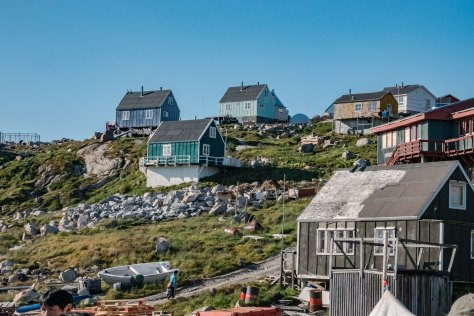
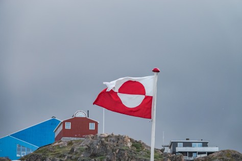
Category Archives: Greenland

Free At Last!

Sept. 7, 2018:


Sure enough, things have changed!  Just after I posted the last time (on Sept. 3rd), we had a new ice chart come in showing that we should be able to safely get out of Prince Regent Sound and through Lancaster Sound on our own without an ice breaker, but that we were headed back to Kangerlussaq, Greenland, to meet the charter flight home. That night, our ship sailed near to the ice edge so we could begin our escape attempt early on the morning of September 4th.

Attempt to Break Free of Prince Regent Strait-1
Sept. 4th-Motoring up to the entrance of Prince Regent Inlet to begin the “escape” attempt
Attempt to Break Free of Prince Regent Strait-10
Blocked
Attempt to Break Free of Prince Regent Strait-12
Blocked
Attempt to Break Free of Prince Regent Strait-13
Blocked

Attempt to Break Free of Prince Regent Strait-15

Attempt to Break Free of Prince Regent Strait-16
Look how deep and sharp this sea ice is!

Attempt to Break Free of Prince Regent Strait-17Attempt to Break Free of Prince Regent Strait-18

Attempt to Break Free of Prince Regent Strait-20
Blocked
Attempt to Break Free of Prince Regent Strait-22
This is when the captain and the ice pilot decided that we aren’t going to get out on our own without an ice-breaker!

Attempt to Break Free of Prince Regent Strait-26

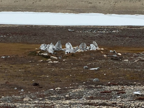
The Captain and the ice pilot made a valiant attempt to free us from the “ice box” on the 4th, but we had to give up once we made it back into Lancaster Sound, as the heavier, thicker sea ice had again shifted, blocking our route to the northeast.  Undaunted, the Expedition team found an inlet which was rich with cultural remains, and they quickly scrambled to set up a Zodiac visit if only to let people off the ship for a while to stretch their legs. Thus, we “parked” in Prince Regent Sound to await the ice breaker.

IMG_2131
Our stop at Cresswell Harbor to view the remains of an Inuit village

IMG_2132IMG_2140IMG_2142

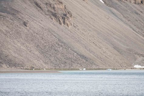
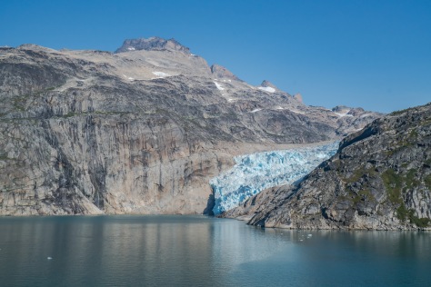
We spent Wednesday, September 5th, motoring around Prince Regent Sound, and pulled into Jackson Inlet on Baffin Island to see what we could see. The inlet is another giant fjord, where the head of the inlet was created by retreating glaciers. Our geologists quickly scrambled to identify the topography as one belonging to a prehistoric coral sea from the Salurian Age.  All we knew was that the beach and hills were covered in layer upon layer of slate-like rocks, which we dutifully scrambled up, so we could claim some exercise for the day.  While it had been a nasty cold day out in Prince Regent Sound, complete with snow blowing; here, in the Inlet, it was calm and somewhat pleasant. By that, I mean that it was not snowing, there were no 35 knot winds, and it was a “balmy” 32 degrees F.  Even better, Jim and I spent a couple of hours on the bridge watching our progress into the bay, and I saw some narwhals deep in the inlet. Of course, by the time we got there, they had slinked away.  Oh, well, we still enjoyed our walk!

Jackson Inlet-1
Yes, it actually was snowing!

Jackson Inlet-2

Jackson Inlet-6
The remains of a prehistoric coral reef.

Jackson Inlet-7

Jackson Inlet-8
There are narwhals there; you just can’t see them.
Jackson Inlet-20
Jackson Inlet landing

Jackson Inlet-24Jackson Inlet-42Jackson Inlet-49Jackson Inlet-50Jackson Inlet-59

That night at our daily briefing, we learned that we had a commitment from the Canadian Coast Guard that we would finally get our ice-breaker at noon tomorrow!  The room erupted in applause. In fact, the sister ship to this one, Le Soléal, would be meeting up with us, because it, too, was stuck in the ice.  It’s going to take at least eight hours to break us free. At the briefing, we also learned that all future trips by Ponant and Abercrombie & Kent have been cancelled. With a firm date in mind for our freedom, and journey back to Greenland, the A & K staff would be busy all day tomorrow making arrangements for us to get home.  We are predicting to be home on the 10thof September after flying by charter from Greenland to Chicago, and then home on individual flights.

Breaking Free of the Canadian Arctic-138Breaking Free of the Canadian Arctic-139

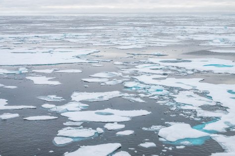
Yesterday was a glorious day as we all flooded out on the decks to watch the ice breaker at work, and to marvel at the passing ice. Polar bears were spotted several times, but most were too far away to photograph. No wonder, given all the noise of crunching ice made by our three vessels grinding through!  About 8 p.m. last evening, the sun came out and shown down on all the new snow that has fallen on Devon Island, which was our last sight of land before passing out into Baffin Bay. We toasted the safe passage with Veuve Cliquot, and sailed into the North Atlantic.

Breaking Free of the Canadian Arctic-2
This is how it looked when we began our journey out of the ice box
Breaking Free of the Canadian Arctic-3
As you can see, it’s already snowed quite a bit just in the last week.

Breaking Free of the Canadian Arctic-18

Breaking Free of the Canadian Arctic-19
Following le Soléal
Breaking Free of the Canadian Arctic-21
Weaving to stay in the path opened by the ice breaker

Breaking Free of the Canadian Arctic-32

Breaking Free of the Canadian Arctic-34
It’s some pretty nasty ice!

Breaking Free of the Canadian Arctic-41Breaking Free of the Canadian Arctic-47

Breaking Free of the Canadian Arctic-56

Breaking Free of the Canadian Arctic-57
Gulp! 
Breaking Free of the Canadian Arctic-146
Finally into free water!
Breaking Free of the Canadian Arctic-151-2
Bye bye, ice!

Breaking Free of the Canadian Arctic-152-2

Breaking Free of the Canadian Arctic-155
On to Greenland!

Moored in Meteor Bay

Aug. 25, 2018:


This morning we awoke to another gloriously sunny day, with calm seas and a balmy 37 degrees F.  here at 76 degrees north.  We are approximately 840 nautical miles south of the North Pole, and this is the furthest north we will go on our trip.  In fact, we were not even scheduled to be this far, but the good weather allowed us to venture further than planned.  Although there is a tiny settlement here, we are not going into town. Instead, our sole activity today will be Zodiak cruising in the bay to see the icebergs.  Although narwhals are plentiful in this area, they are extremely skittish being hunted by both man and polar bears.  Our expectations have been set very low. Most naturalists who work in the Arctic say they have seen the narwhals less than 5 times in their lives. Bummer!

Meteor Bay-5
New friends, Barbara and Neil Hoffman

Nonetheless, we had a glorious cruise among the icebergs on another calm, still morning. All of the naturalists onboard have told us they have never seen so many icebergs in this bay before, and the shapes were crazy.  Every one had a great time letting their imaginations run wild seeing speculating what animals appeared to them.  We saw dragons, and an old Inuit woman with a parka, and a Hershey’s kiss. From the Zodiac, we also saw a flash of a snowy owl out hunting for his breakfast, but by the time I got my camera to my eye, he was gone.  One of the boats saw a seal, but we didn’t see any other life.  However, the marine biologist on board captured some sea butterflies (snails with bifurcated mantle/feet which they use to propel themselves through the water) and a sea angel, which eats the sea butterflies. They were released immediately back into the water as we left Meteor Bay.  Now we sail across Baffin Bay, where we should make land in Pond Inlet up at the top of Baffin Island by noon tomorrow. I stayed out on deck as we passed Cape York, which is the closest point we had been in Greenland to Canada. Then I spent the rest of the afternoon going to a geology lesson, editing photos, and taking a workshop on learning to use watercolors to depict natural flora and fauna.

Meteor Bay-23Meteor Bay-34Meteor Bay-37

Meteor Bay-39
Old Inuit Woman in the Ice
Meteor Bay-46
Dragon?

Meteor Bay-50Meteor Bay-52Meteor Bay-60

Jim and I finished the day by watching a documentary about one of the staff members on board, Mike Stevens.  Mike became an international sensation as a harmonica player, playing mostly blue grass music and even performed several times at the Grand Ole Opry. However, about 20 years ago, he was made aware of the plight of the young people in the far northern Canadian provinces. The documentary is called A Walk in My Dreams, and documents how Mike has devoted the last 20 years to trying to save those youths by providing instruments and music instruction for those tribes.  It was pretty graphic, but apparently, it’s been very successful as an intervention in saving these kids’ lives. If you are interested in donating to his non-profit, you can donate to ArtsCan Circle.  (www.artscandcircle.ca). We look forward to meeting some of the kids and communities Mike has worked with in the upcoming days.


We topped the day off watching the sunset at nearly 11:00. Wow!

Meteor Bay-73

Calling On Kullorsuaq

Aug. 24, 2018:


We continued our cruise north along the coast of Greenland today.  Our port of call is in the southern end of Melville Bay at the tiny town of Kullorsuaq on an island of the same name.  We are at 74 degrees north latitude. For those of you who are wondering, the Arctic Circle is generally accepted to begin at 66 degrees north latitude. Already we can see that the tiny plants found in the tundra are beginning to turn color for autumn.

Kullorsuaq-21Kullorsuaq-36

Kullorsuaq-3Kullorsuaq-55

Kullorsuaq-58

Kullorsuaq-60
The town of Kullorsuaq

Kullorsuaq-24Kullorsuaq-66

Nonetheless, we scored another perfect sunny day for our sail. From where we are off the coast, you can look directly into the interior of Greenland a look at the vast stretches of the Greenland Icecap.  The captain is winding his way slowly among the icebergs, which cover more and more of the sea every day.  The island we will be visiting was among the earliest settled areas of Greenland, dating back about 4,000 years.  Those peoples were part of the first wave of Inuit peoples from Northern Alaska and the Bering Strait known as the Paleo Inuit. There were three phases of the Paleo Inuit, starting with the Saqqaq peoples, who were present from about 3000 BC to 1300 AD. The Saqqaq peoples were followed by the Greenland Dorset peoples. However, then, somehow the Paleo Inuit died out. There was a second wave of Greenlandic settlement also by Inuit peoples from northern Alaska and the Bering Strait, and this group of settlers is known as the neo-Inuit peoples. Interestingly, these people are different genetically from the Paleo Inuit, although they came from the same geographical area.  The Neo Inuit are the predecessors of the modern day Inuit in Greenland.

Kullorsuaq-68

Kullorsuaq-75
at the crafts tables.

Kullorsuaq-170Kullorsuaq-174Kullorsuaq-177

Kullorsuaq-76

Our activities for the day include a visit to the small village of Kullorsuaq, where we will get to meet the people and wander about inn the town, and later in the day, the villagers will return with us to ship to show us some of their traditional dress, and perform songs and dances.  The village itself is fairly small (only about 500 inhabitants, and pretty much the whole village works in the fishing industry, catching and processing halibut year round. Jim and I were able to try some of this great halibut for dinner last night, and you can’t believe how delicate and moist it is.

Kullorsuaq-82
Views from the village

Kullorsuaq-87

It’s another blue bird day here above the Arctic Circle with temperatures in the low 50s.  As we sailed into the harbor about noon, several of the townspeople turned out down by the water to greet our Zodiacs.  This village is not on the tourist circuit, but one of the Ponant captains forged a friendship with the villagers and they eagerly await the infrequent visits the Ponant ships make to the area.  However, the town appeared fairly prosperous, with many of the villagers sporting name brand sneakers and carrying iPhones, and the town has a huge satellite tower with several receivers.  Everyone we met was very friendly, and because of the sun, all the kids in town were outside playing.  Speaking of the kids, there are about 100 kids in the town, and the town has schools up through high school. After that, the kids must go to Nuuk or to Denmark to go to college.Kullorsuaq-78

Kullorsuaq-127Kullorsuaq-134

Kullorsuaq-142Kullorsuaq-149Kullorsuaq-156

Several of the villagers were selling artisan items. Most of the women do intricate bead lacework, which the make into collars and cuffs as part of their traditional wear, or into earrings and other less traditional uses.  All of the villagers supplement their seafood diet with land animals they hunt such as caribous, rabbit, ptarmigan (small grouse-like birds), and musk oxen.  However, their favorite food remains seal and narwhal, although they also eat whale.  I was pleased not to be offered a sample of any of these.

Kullorsuaq-158

Jim and I walked around the town, and I was constantly awed by how striking the features of the Inuit people are. Although some clearly look more like our native tribes, others have very Asian features, and some even look like ethnic Russians or Mongolians.  Yet most of them have very Scandinavian names like Lars or Irina. Further on, we were delighted to find several litters of sled dog puppies being raised by different families in town. One of the men is known as a great hunter, and I couldn’t count all the dogs he had.  There were two polar bear skins drying in the sun over his porch railing.  Our walking tour quickly over, we returned to the boat ramp, and had fun capturing all the kids playing in photos.

Kullorsuaq-98
Sled dog jumping on a packing crate
Kullorsuaq-101
Sled dog puppy
Kullorsuaq-105
More sled dogs at the hunter’s house. Notice the polar bear skins drying in the air.

Kullorsuaq-106

Kullorsuaq-163Kullorsuaq-167

We headed back to the ship, and got cleaned up, and then about 20 of the villagers came aboard to show us their traditional dress, and then they performed some traditional songs and dances. From my perspective, the highlight of the performances was a couple of dance routines by some of the teenage girls.  Much to the surprise of many of our fellow passengers, their dances were NOT of the traditional type!  The girls obviously made use of the good Internet in town to learn very modern dance moves set to current Danish and American pop music. They were darling!

DSC00995

Tomorrow, we will hit our furthest north when we pull into Meteor Bay at 76 degrees north.

Following the Fjords

Aug. 23, 2018:


This morning we had a glorious cruise through the Uummannaq and Karrats Fjords.  It was a bracing morning to be up on deck, and the views of the glaciers and the icebergs were spectacular.  Mid-morning, we also had a very entertaining historical lecture about the great Norwegian explorer, Fridjof Nansen.  There was a spotting of a caribou on one of the ridges next to a glacier, but I never did see it.


By mid-afternoon, we had anchored off of Karrats island, and took the Zodiaks onshore to see some cultural remains of a small settlement which dated back to the late nineteenth century.  We were able to see the remains of very small turf and stone huts, as well as a small graveyard now exposed by the elements and scavenging animals.


One of the bear guards spotted a young Arctic fox, but the closest we came to seeing him was spotting his spoor.  Instead, we hiked up a slope above the beach and enjoyed some great views of the fjord. Since it was a fairly warm day (by Arctic standards), with temps up to 50 degrees F., the icebergs were calving regularly, and we got to see a great calving right offshore.


We concluded the afternoon with a Zodiac tour among the icebergs.  We saw one little berg that was so clear it looked like a piece of carved crystal. Another huge berg had a piece gouged out of its side that looked exactly like a snake flicking its tongue out.


Tomorrow morning, we have another long steam before we come into the very small village of  Kullorsuaq on an island of the same name, in the southern end of Melville Bay

Intriguing Illulissat

Aug. 22, 2018:

This morning, we had a lovely sail into Disko Bay, where the sight of icebergs floating everywhere met us upon awakening.  Once again, we have a full day on tap. We first went out on a cruise of the bay so we could see the icebergs up close and personal, and the end of the Illulissat Icefjord.  We lucked out with a really gorgeous, calm morning, and almost as soon as we pulled alongside the glacier, we saw a mother and calf humpback whales feeding at the foot of the icebergs.


Later, we saw a whole large group of seals also feeding. The bay is just gorgeous, and the cruise was just the beginning of a great day.


Once back at the boat, Jim and I took one of the Zodiac tenders into town to walk around. We had a mission, because somehow in transit, my tripod had broken. Today was probably my last chance to find a replacement, since there won’t be any more shops after this. Fortunately, we found the best electronics store anyone could have imagined, and they hooked me up with a new tripod. With that mission accomplished, Jim and I went back to the ship for lunch.


This afternoon, we had a great hike to the base of the Icefjord. The valley next to the fjord is a UNESCO site, not just because of the glacier, but also because it is filled with cultural remains of the earliest recorded inhabitants of Iceland dating back 4500 years.  The most recent of those were known as the Thule people, and they were the ancestors of the modern Greenlandic people.

I wish you could see the photos, but the Internet is really poor here.  Sadly, this may be the last of it we see for the remainder of the journey.  So I’m just going to post this without photos and say farewell for now.

Sizing Up Sisimiut

Aug. 21, 2018:

This morning, we docked in the port of Sisimiut about 6 a.m.  There’s really not much to do here, but we can definitely tell we are in the Arctic, as the day chilly and overcast with winds gusting at 25 mph.  However, we bundled up, and set out for a walking tour of the town with our local guide.

Sisimiut-65Sisimiut-38

Immediately, Jim and I are reminded how pretty these Greenlandic towns are, with virtually all of the buildings being painted bright colors.

Sisimiut-38Sisimiut-74

Our first stop is at the boat wright’s shop, and then we made our way up to the old church, which has now been turned into a museum. Our guide tells us that the population of the town has grown so much (they now have 6,000 inhabitants) that the town is considering building a newer new church to accommodate everyone.

Sisimiut-22

Sisimiut-21

Sisimiut-26Sisimiut-32

Sisimiut-39Sisimiut-65


We finished our hike around town, and returned briefly to the ship.  Then I sprinted back to town to hang out at the Seamen’s Café and use their Internet to upload some photos for you, Dear Readers. Walking briskly back to the ship, I visited the local artisans’ workshop (being careful not to buy anything made from seal, whale, or other cute animals), and then returned for some lectures by our onboard naturalists.

Sisimiut-95


We were also treated to a demonstration of a local Inuit showcasing his kayaking skills by rolling his kayak over and over in the semi-freezing water.  Then we sailed away into the increasingly pitching seas.

Sisimiut-113-2

Sisimiut-114-2

Tomorrow, we visit Illulissat; Greenland’s third largest town (population: 4, 500), and a UNESCO World Heritage Site recognized for its famous glacier, Illilusiat Icefjord.

Getting Back to Greenland

Aug. 20, 2018:

Today was spent mostly in travel; up before dawn, flight to Greenland, and transfer to our ship. We are traveling on Ponant’s ship, le Boreal, the sister ship of the vessel we took to Antarctica.

There is not much to report from today, except that the views from the plane were spectacular as we flew into Kangerlussuaq.

Kangerlussuaq-3Kangerlussuaq-10

Kangerlussuaq-19Kangerlussuaq-26Kangerlussuaq-41

Tonight we will sail about 150 nautical miles out the long fjord where Kangerlussuaq is located to the second largest town in Greenland, Sisimiut.

Our Princely Passage Through Prinz Kristian Sund

August 30, 2017:

Jim and I arose with the dawn on this, our last day in Greenland. And what a grand day it was!  We bundled up to survive the cold wind off the glaciers, and rushed up on deck. At 7 this morning, we began our 7 hour passage through Prinz Kristian Sund (Prince Christian Sound), named for the late Prince, and later King of Denmark.

Prinz Kristian Sund-3

Prinz Kristian Sund-7


As Wikipedia says: “The Prince Christian Sound connects the Labrador Sea with the Irminger Sea. It is around 100 km (60 miles) long and it is narrow, sometimes only 500 m (1500 ft) wide. There is only one settlement along this sound, Aappilattoq.

The long fjord system is mostly surrounded by steep mountains reaching over 1200 m height. Many glaciers going straight into its waters calving icebergs.”

Once again, we have been blessed with a glorious day for this passage. In fact, until last night, we were not even sure we were going to be able to do this part of our trip, as all the calving glaciers can create so much sea ice and glaciers that the passage can become unsafe, which happened to another ship just three weeks ago.  While there is a possibility of seeing marine life, and animals on the surrounding slopes, the real show of the day is the topography itself. The steep walls of the main fjords and those that branch off from them are crowned with numerous glaciers, both hanging, and some reaching the sea. The water itself is a mix of saltwater overlaid with fresh water laying on top from the melting glaciers. Jim and I watched awestruck as we glided through this incredible fjord.

Prinz Kristian Sund-10Prinz Kristian Sund-16

Prinz Kristian Sund-18

Prinz Kristian Sund-22Prinz Kristian Sund-29

Prinz Kristian Sund-33

Prinz Kristian Sund-88

Prinz Kristian Sund-126

Prinz Kristian Sund-148

Prinz Kristian Sund-151

Prinz Kristian Sund-186

Jim and I have been fortunate enough to see both the Alaskan glaciers in the Bay of Glaciers and the Patagonian glaciers in Chile and Argentina. However, this is really a contender for the most awe-inspiring glacier cruise! To cap matters, the whole 100 kilometer channel is incredibly remote, with much of the passage blocked by ice most of the year. The only settlement of any size is the tiny town of Aappilattoq, which we passed about two hours into the transit. Waving goodbye to Aappilattoq, we allowed ourselves to go downstairs for breakfast. It was such a beautiful day, we actually ate outside with a prime view of the glaciers behind us.

Prinz Kristian Sund-186

Prinz Kristian Sund-205
Tiny Aappilattoq

Prinz Kristian Sund-32

Prinz Kristian Sund-207

In addition to the incredible views of the glaciers, there were also countless icebergs, and a constant wash of “sea brash” (the smaller iceberg pieces that litter the surface of the water. At one point, we all became very excited because we thought we saw a large seal sunning itself on an iceberg. However, it was just a bit of dirty ice caused by the terminal moraine at as the iceberg relentlessly ground itself down to the water and calved from its glacier. Darn! However, in my opinion, by far and away the best feature we saw was a glimpse into the massive Greenland ice sheet.Prinz Kristian Sund-213

Prinz Kristian Sund-250

Prinz Kristian Sund-240

Prinz Kristian Sund-248

Prinz Kristian Sund-252

Prinz Kristian Sund-113

Prinz Kristian Sund-120

Prinz Kristian Sund-440
“Seal” fake out
Prinz Kristian Sund-162
Exiting Prinz Kristian Sund

Prinz Kristian Sund-239

Prinz Kristian Sund-264

Prinz Kristian Sund-313

Finally, about 1:30, we exited fjord, and sailed out into the Irminger Sea.  Our naturalist aboard, Dr. Michael Scott, had told us that this stretch to Iceland is some of the best whale watching area in the world, so we didn’t want to miss a minute.  Jim and I took a break about 1:45 for a belated lunch. While we were eating on the stern veranda, sure enough, at least 25 whales passed by, spouting off like a calliope, but no photos as they were too far away (and my camera equipment was having a well-deserved nap).

Prinz Kristian Sund-335
Southern tip of the Greenland ice cap


Qaqortoq. Yes, It’s a Place.

August 29, 2017:

Although still chilly this morning, it is not the bone-chilling cold of yesterday as we pull into the harbor of Qaqortoq, on the southwestern coast of Greenland. This town is very small, but not as small as Paamiut. Fortunately, the sun is shining, as we have a hike planned along a lake, which lies just outside of town. The walk through town is charming and everyone seems to have flung open their doors to greet us (or maybe just the sunshine). We expected another cold day today, but we were shedding layers before we even started our walk/hike.

Qaqortoq-1

Qaqortoq-2Qaqortoq-11

We’re pretty much at the far southwestern tip of Greenland, which was originally populated by the Saqqaq people about 4300 years ago. There are some records of habitation dating from the Dorset peoples of NE Canada about 2300 years ago. However, recorded history dates back to the first Norse settlements established in the late 10th Century A.D., especially around the Hvalsey settlement, which is about 19 kilometers (12 miles) to the NE of Qaqortoq. However, for whatever reasons, those settlements died out in the 15th Century, and the current habitation dates only to 1774, when a Danish-Norwegian trader named Anders Olsen established a trading post here, originally called Julianehåb (Juliane’s Hope) after the Danish queen. Fast forward to the present day when we find Greenland a semi-autonomous state, still largely dependent on Denmark for trading and funding. The main industries are fishing and seal-hunting, and Denmark purchases about 60% of the economic output of this isolated town of just of over 3,000 people. Sadly, like in Paamiut, it appears most of the tourist souvenirs appear to be sealskin products. Sad!

Qaqortoq-16Qaqortoq-17

Qaqortoq-19

Qaqortoq-21

Qaqortoq-27

With that, we were happy to proceed to our walk in the outskirts of town! The hills ringing the town appear to be a combination of granitic and basaltic stones, on which lichens and mosses appear to be struggling to survive. There are no trees here, but, upon closer inspection, you notice a whole alpine-like ecosystem covering the hills. There are tiny streams everywhere, and furzes and heathers cover the rocky ground, punctuated by tiny wildflowers and wild berries including Icelandic blueberries and cow berries. The hills are open to anyone who desires to gather them and they are all ripening now. Because the day is so still and calm, the lake surface is like a mirror, which makes for some great photography! Jim and I walked about six miles in total along the rocky lakeside path, winding up back in town. We sampled one local beer at the local tavern, and then headed back for the ship.

Qaqortoq-29

Qaqortoq-39
Arctic vegetation

Qaqortoq-40

Qaqortoq-42Qaqortoq-57

Qaqortoq-61
Gathering Arctic Blueberries

Qaqortoq-62Qaqortoq-63

Qaqortoq-73Qaqortoq-80
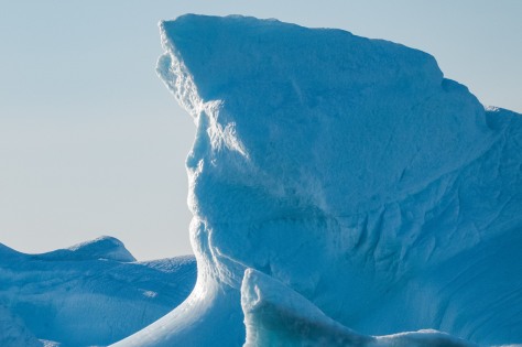
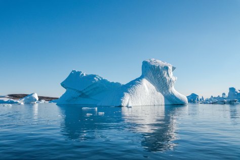
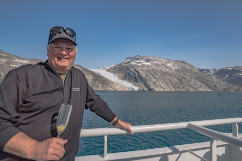
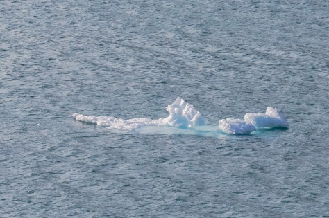
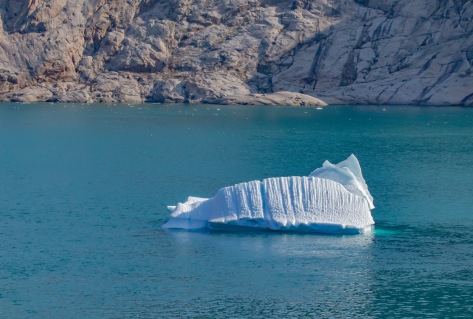
Once again, we are blessed with a beautiful sail away. It’s even warm enough that Jim strips down a shorts and flip flops, even though we can see little icebergs bobbing in the bay.

Qaqortoq-81

Qaqortoq-82

But, first, a lovely parting gift from Qaqortoq … as Jim and I were having a cocktail standing at the balcony of our cabin, a juvenile humpback whale surfaced right below us, and spouted off. What a fun send off!Qaqortoq-86

Juvenile Humpback surfacing right under our balcony

Qaqortoq-88Qaqortoq-89

Qaqortoq-106
Bye bye, icebergs!

Tomorrow, we are looking forward to a day-long transit of Prinz Kristian Sound; a deep fjord system that bisects the lower tip of Greenland from its southernmost Cape Farewell archipelago.

“Madam: There’s an Iceberg in My Sea”

August 28, 2017:


Yes, that’s the view that greeted us when we threw open the shades this morning as we sailed into the glacial bay in which the harbor of Paamiut is located. We appear to have lost our sunshine in Nuuk, and it’s a foggy, overcast morning here in Paamiut. Whereas Nuuk is the major city in Greenland, Paamiut is tiny; consisting of only about 1,500 inhabitants. In fact, there are only about 50 vehicles here!

Paamiut-1

Paamiut-3

We bundled up well, because it’s only 38 degrees outside, and there’s a light wind blowing, which intensifies the cold. Then we took the tender into the town for a short walking tour to get to know Paamiut. This tiny town was established in 1742, as a trading post by a Danish trader named Jacob Severin. The town was originally named Frederikshåb (Frederick’s Hope) after Crown Prince Frederick (later King Frederick V) of Norway. The town prospered mostly on fur and whale products. In the 1950s, it boomed following the cod fishing boom, and in the 1960s, the town was consolidated and a number of larger apartment blocks were built to lure people living around the town to come into the center to help in the cod fishing industry. However, when the cod fishery almost died out in the early 1990s, so did the town.

Paamiut-13

Paamiut-8

Paamiut-17
Regional Administrative Office
Paamiut-14
Nursery School
Paamiut-16
Main Street, Paamiut

We were met at the docks by a local guide. She walked us around, and proudly pointed out all the buildings of importance in the town. One thing you notice right away is how many schools and activity centers there are for the youth. Our assumption is that they must be pretty heavily subsidized by the Danish government because there just isn’t that much industry of any kind here, and tourism is merely an afterthought. However, like in Nuut, all the buildings are painted bright cheery colors.

Paamiut-19

Paamiut-26

Paamiut-33
Fredenskirche with its memorial graveyard


There is one building, in particular, of which the villagers are really proud. It is the local church, Fredenskirche, built in 1909 in the Norwegian Hansel and Gretel style. Looking at it, you could see where model for gingerbread houses comes from! The graveyard in the churchyard and a monument across the street memorialize fishermen lost at sea. There is also a replica of a traditional Greenlandic sod house. Also, exactly one supermarket, one grocery store, a café, one gift shop, and a couple of bars. Residents all seem to carry cell phones, but the ship has had no Internet since yesterday (sporadically), and there is nowhere in town to get WiFi. Having concluded our tour, we were happy to head back to the ship and thaw. Hopefully, there will be more warmth and sun tomorrow as we head south about 150 miles to Qaqortoq.

Paamiut-40
Replica traditional Greenlandic sod house

Paamiut-42

Paamiut-44
Tiny interior of same