Porto Grande, Cape Verde Islands

October 30, 2016:

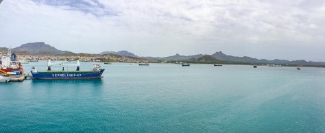
After 2 days at sea, sailing down the west coast of Africa (and pinching ourselves with the marvel of it), we came into the Cape Verde Islands on the island of Saō Vicente (and docked in the port of Porto Grande) this morning.

cape-verde-islands-141

cape-verde-islands-140


cape-verde-islands-133cape-verde-islands-136

cape-verde-islands-125


But first, many of you wonder how we can stand the large number of days we have at sea between many of our ports.  Let us assure you; it’s no hardship at all!  We usually rise at a decent hour, and go down to the formal dining room for a sit down breakfast served precisely to our choice. If we want, there’s always a Canyon Ranch approved spa menu, but there is no lack of other choices.  Our ship was extensively renovated this year, and one of the best improvements was a considerable upgrade to the ship’s satellite WiFi capability, which is what is making these posts possible.  This upgrade also allows us to get MSNBC in our room, so we can stay up to date on the insanity of this year’s election.

After breakfast and a little telly, there is a Smithsonian lecturer aboard who presents a different lecture every day at sea.  The theme this cruise is a series on the lives and contributions of numerous explorers, and the lectures are really fascinating! We usually follow that by an hour walking around deck while we listen to some of our favorite podcasts. There are also many other activities such as wine tasting, bridge games and lessons, dance lessons, a casino, and a Canyon Ranch Spa, and full exercise facility with occasional classes.  Truthfully, I usually spend some time on deck with Jim, but mostly spend my time editing photos and writing blog posts while watching the waves go by.

Now, onto the country of Cape Verde. That’s right; it’s a separate country, having enjoyed its independence since 1975.  The country consists of 10 islands about 500 miles off the coast of Africa. A former Portuguese colony, Portuguese remains its primary language, although the natives also speak a form of Creole which is Portuguese-based.  Originally having fought Portugal for its independence with the help of another former Portuguese colony; Guinea Bissau.  Originally, Cape Verde and Guinea Bissau formed a joint country, but in 1991, Cape Verde broke away peacefully to form its own country, largely because the Cape Verdeans felt the corruption in Guinea Bissau threatened their country’s democratic practices and traditions.

Jim and I were really impressed with not only the extremely strong democratic history of Cape Verde (the African nations confederacy uses its citizens as poll watchers in other countries to try to assure fair elections in those other countries), but at all they have achieved since declaring independence. Make no mistake, this is an incredibly poor country with virtually no natural resources. Our tour guide told us the only resources Cape Verde has are the sun and the wind!  However, since independence, the Cape Verdean people have gone from a literacy rate of about 60% to a literacy rate of 95%.  With a population of just about 500,000 (with over 600,000 expat Cape Verdeans), about 66% of its population still living in the islands is under 25 years of age.  While unemployment remains high at about 23%, education is hugely subsidized by the government and several universities exist in the islands.  For example, our tour guide is employed as a mechanical engineer at the national electrical plant during the week, but gives tours to supplement his income on the weekends.

Everything the Cape Verdean government does seems to be directed at preventing greater ills. Accordingly, medical care is widely available and very highly subsidized with all preventive care not just covered, but actively encouraged.  This results in an infant mortality rate of  just 1 in 100 births. Likewise, seeing the ravages wrought by HIV throughout the rest of Africa, Cape Verde has maintained an AIDs infection rate of just 1% through an active campaign of education, condom distribution and free AIDs treatment.  Social Security is provided beginning at age 65, and we saw a new affordable housing project whereby the unemployed or underemployed can pay a small amount according to ability.  The complex was beautiful and modern, and included a health clinic and a school.

cape-verde-islands-128

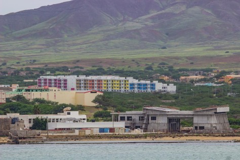
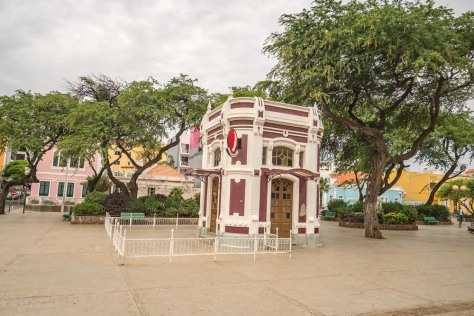
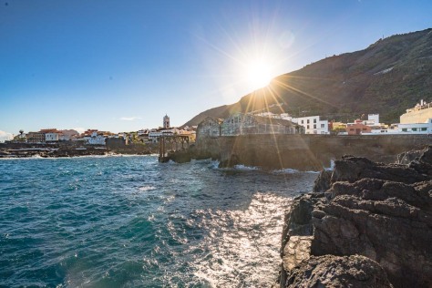
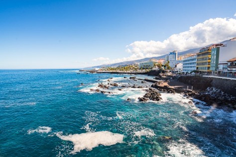
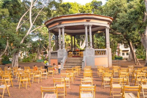
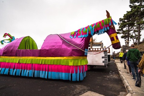
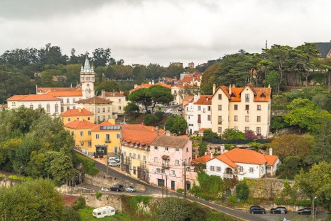
OK; enough statistics, let’s get on with the tour. Jim and I signed up for a tour which consisted of a bus tour around most of the island with stops at the scenic highlights.  As we drove into the town of Mindelo, we could see evidence of its colonial past with beautiful pastel-colored colonial architecture. We drove past the African market, but most of the stalls were closed because it is Sunday. It was also fun to see some had decorated for Halloween, which our guide tells us is a big excuse to party.cape-verde-islands-5cape-verde-islands-9

cape-verde-islands-11
The African Market (Praca Estrela)
cape-verde-islands-100
The “Pink Palace”

cape-verde-islands-6cape-verde-islands-7

cape-verde-islands-101

cape-verde-islands-103
Praca Nova (main square)

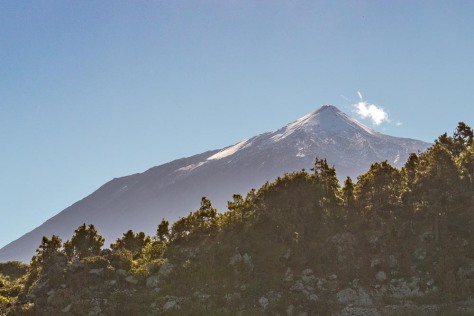
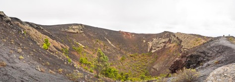
Cape Verde is also part of the volcanic chain formed by the eastern Atlantic tectonic plate.  The islands appear older here, in that the volcanic peaks appear more eroded an a slightly lighter shade of blackish brown. We are fortunate to be stopping here at this time of year, though, as the rainy season has begun and the whole island appears green with low vegetation, and everyone seems to have planted a corn crop wherever they could scrape out a small plot of land. None of this farming is mechanized, and you see the people all carrying hand tools to tend their small crops in the incredibly rocky soil.  About the only trees that appear to grow in the inland of the island are small shrubby acacias.  While palms and tropical fruit trees dot areas along the inhabited parts of town, not many other trees grow outside the villages.

cape-verde-islands-15

cape-verde-islands-19

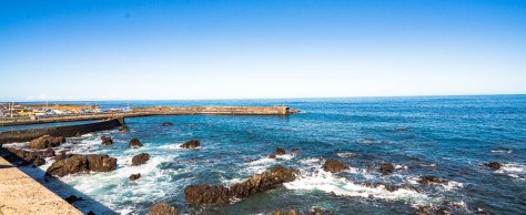
Our first stop is up a cobblestoned road to the highest peak on the island, Monte Verde.  The views are very beautiful, and we can see our ship anchored in Porto Grande.

cape-verde-islands-36cape-verde-islands-37cape-verde-islands-39cape-verde-islands-43

cape-verde-islands-139

Our next stop is at a place called Catfish Bay, and we can see the influence of the many foreign visitors and Cape Verdean expats who own homes near the beach here. Apparently, this is a favored tourist destination for the huge music festival they hold on a huge stage on the beach the weekend of the full moon.  Many expat Cape Verdeans time their summer vacations so they can attend this party.

cape-verde-islands-51cape-verde-islands-52

cape-verde-islands-53
The party stage in the distance

cape-verde-islands-54

cape-verde-islands-49

cape-verde-islands-57

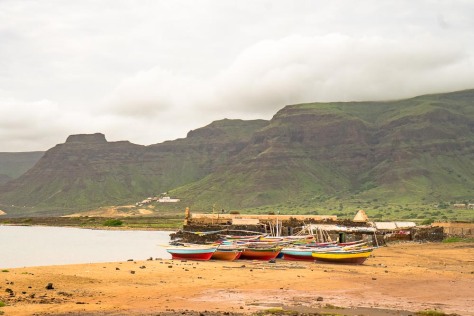
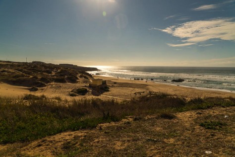
We then drove along the coast and started noticing white sand beaches and dunes. Our guide explained that since this a windward island, the sands from the Sahara blow over 500 miles to get here and are trapped by the high volcanic mountains so they drop onto the beach here. Our next stop is at Praia Grande, which is a popular destination for the island residents because of the white sands which have accumulated here.  We celebrated our walk on the beach by trying a shot of the local liquor distilled here called grogue, made from sugar cane.  It mostly tasted like really astringent rum.  We were not compelled to rush out and order a cocktail made with the stuff!

cape-verde-islands-63cape-verde-islands-67cape-verde-islands-69cape-verde-islands-71

cape-verde-islands-75cape-verde-islands-77cape-verde-islands-78cape-verde-islands-82cape-verde-islands-85cape-verde-islands-86cape-verde-islands-88

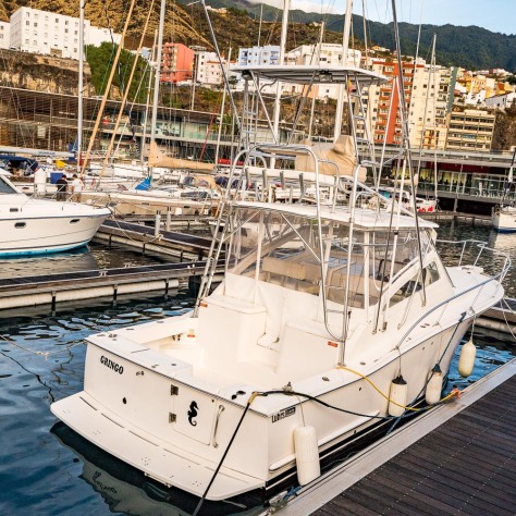
Finally, our tour stopped in an agricultural valley which is fed by a stream which eventually empties into the Atlantic, but it appeared what stream there was ran underground because all the crops in this valley were supplied by windmill-operated pumps. Although the Cape Verde islands were discovered by Portugal in 1462, it wasn’t really developed at all until the 19th century because of the lack of water. However, the town of Mindel was formed in 1795 because its natural harbor provided a safe berth, and it became a coal depot for Atlantic steam ships starting in the 19th century.

cape-verde-islands-93cape-verde-islands-96cape-verde-islands-97

We then returned to the ship, and prepared to cast off for Dakar, Senegal. We can’t wait to see what it holds for us!

A Tweet of a Different Type (Hint: We’re Still in the Canaries)

Oct. 27, 2016:

This morning, we woke to darkness as we continued into the port of Santa Cruz, on the island of Tenerife, which really wasn’t as early as you might have thought since sunrise doesn’t happen until about 8:15 local time in this part of the world.

This island is the largest in the Canary archipelago by square footage, and boasts  a population of nearly 1 million residents. Tenerife is one of the best known and most popular in the island chain, and sees about 6 million visitors per year. The port of Santa Cruz is in the northeastern part of Tenerife, but the most visited tourist areas are in the southwest part of the island, where countless beach resorts exist. Accordingly, tourism accounts for about 75% of the local economy.  However, the bananas grown in huge plantations here, and the local wine (again, mostly Malvasia) also contribute a major proportion of the economy.

santa-cruz-de-tenerife-86

Like the island of La Palma, Tenerife was born from volcanoes, and the largest/highest of those, Mount Teide, is the highest peak in Spain, towering as it does over 12,000 feet above sea level.  Weirdly, while it is always very temperate along the sea coast of the whole island, it is much colder just a few kilometers inland.  Just two days ago, it snowed on the peaks of Mount Teide; a snow the locals said was the most severe in about 20 years!

As we drove inland from Santa Cruz through the adjacent suburb of La Laguna, we can see the northern airport, which still holds the record for the largest airline accident ever in 1977.  As we drive, we catch sight of Mount Teide covered in snow.  We are on the way to the seaside town of Garachico, and then back through the resort town of Puerto de la Cruz, also on the northwestern coast. Again, like La Palma, for miles, you see verdant band fields marching up the hills from sea level, gradually giving way to grape vines, palm trees and cactus (mostly prickly pear and something that looks like the cacti we saw in the Galapagos islands).  Again, the upper elevations have numerous stands of Canary Island pines. In short, it’s a beautiful drive.

When we arrived in Garachico, we found a town dating back to the sixteenth century, but one which has known much adversity over the years, including the eruption of the local volcano in 1706, which moved the coast about 1/2 mile westward, and totally destroyed the local viticulture.  In the old center of town, you are able to see the former port gate entrance to the town, now completely landlocked.The most recent disaster happened just tow days ago, when the same huge storm which blanketed Mount Teide with snow flooded Garachico with rain and waves so large it washed out many seaside fences and shut down the highway with flooding.  One local said it was like a “mini-tsunami” hit the town.  Nonetheless, it was fun to walk among the colonial buildings washed in the early morning sun.

santa-cruz-de-tenerife-18

santa-cruz-de-tenerife-21santa-cruz-de-tenerife-22santa-cruz-de-tenerife-26santa-cruz-de-tenerife-30

santa-cruz-de-tenerife-33santa-cruz-de-tenerife-38santa-cruz-de-tenerife-39

From Garachico, we drove up an incredibly winding road to reach the connection with the main highway back to Santa Cruz.  We stopped for a coffee at a restaurant at the top, named, appropriately, Mirador de Garachico (Viewpoint of Garachico). The views of Garachico over 2,000 feet below us were spectacular, as was the view of Mount Tiede off in the distance.  From here, you could really see the progressive changes in vegetation, as the banana plantations gave way to grape vines, and finally were crowned by forests of Canary pines.

santa-cruz-de-tenerife-59
Mirador de Garachico
santa-cruz-de-tenerife-63
Mount Teide

Our tour wound up in the seaside resort town of Puerto de la Cruz, which was the first town on the island to become a resort destination. Many famous people have traveled here. Notably, Agatha Christie stayed here for quite some time, and wrote two of her novels here, reportedly while nursing a broken heart caused jointly by the death of her mother and her divorce.  This town is definitely someplace you would like to travel to and experience!  The town council has erected some amazing public bathing pools alone the seashore which incorporate some of the lava outcroppings.  Further, several hotels along the main street have also built giant water parks along the sea.  If you aren’t a guest of one of these hotels, or don’t want to pay for the right to use the community pools, lots of people still enjoy swimming in the sea. This is all made possible, despite the rough waves and menacing lava rocks by the creation of several little mini-ports for swimmers along the inner bay.  Jim and I enjoyed our walk along the seaside, but were ready to return to the ship.

santa-cruz-de-tenerife-75santa-cruz-de-tenerife-76santa-cruz-de-tenerife-79santa-cruz-de-tenerife-80santa-cruz-de-tenerife-83

santa-cruz-de-tenerife-85

santa-cruz-de-tenerife-87

santa-cruz-de-tenerife-90santa-cruz-de-tenerife-96santa-cruz-de-tenerife-101santa-cruz-de-tenerife-102santa-cruz-de-tenerife-104

This afternoon, we ventured out on another tour; this time of colonial Santa Cruz.  We had a local guide, Laura, who was a real Spanish spitfire!  She did a great job of imparting her love of her home town along with a healthy dose of history, including the fact that Admiral Horatio Nelson lost one of his rare sea battles here fighting the Spanish navy, a loss which cost him his arm. The arm still remains in Santa Cruz, but Nelson was allowed to return to England after surrendering to the Spanish.

santa-cruz-de-tenerife-115

santa-cruz-de-tenerife-118
Map of early Santa Cruz, complete with the outlines of the Castillo de San Cristóbal
santa-cruz-de-tenerife-122
Cannon from the old Castillo

santa-cruz-de-tenerife-123

santa-cruz-de-tenerife-130

santa-cruz-de-tenerife-153-edit

The town has its expected collection of colonial remains and churches, but it has also done a great job of keeping up with the times. Really, it’s a lovely town, with beautiful parks and squares, and lovely tree-lined walkways, complete with music in the main bandstand. In fact, we passed multiple buildings which support all types of musical and theatrical arts, and we heard several choirs practicing through the open windows.  The older buildings have been well-restored and the newer buildings merge harmoniously with their older neighbors. Probably the most notable structure for architectures buffs, though, is the amazing opera house designed by famous Spanish architect, Santiago Calatrava, which looks like a smaller version of the Sydney opera house with a sail stretching over it.

santa-cruz-de-tenerife-113santa-cruz-de-tenerife-128

santa-cruz-de-tenerife-135santa-cruz-de-tenerife-138santa-cruz-de-tenerife-140

santa-cruz-de-tenerife-143

santa-cruz-de-tenerife-110
Calatrava-designed Opera House

santa-cruz-de-tenerife-154

The real reason we decided to take this tour, however, was the lure of tasting some of the local tapas and wine.  We did these tastings at two restaurants, and were pleased with both. Notably, local goat cheese was yummy, and often wins prizes at global cheese competitions. Content and relaxed, we walked back to the ship in the golden hour.  Tonight our ship sets out to sea at midnight for a two-day sail to the Cape Verde Islands, where we will be exploring the island of Porto Grande.

Volcanoes and Vineyards

October 26, 2016:

This morning, we docked at dawn in the Canary Islands, on the island of La Palma. The port is located in the town of Santa Cruz de la Palma. Even though we’re only about 130 miles off the coast of Morocco, the islands belong to Spain, stretching back to Christopher Columbus’ time. Like to Galapagos, these islands are all volcanic islands, and there is black balsamic rock everywhere.

santa-cruz-de-la-palma-1

First order of business, Jim and I got off the ship so we could photograph it for you, dear Readers.  santa-cruz-de-la-palma-5

santa-cruz-de-la-palma-305santa-cruz-de-la-palma-306santa-cruz-de-la-palma-307

On the way off the boat, we spied what may be our future boat.

santa-cruz-de-la-palma-11

We took a walk through the old town, which is charming!  The most notable architectural feature is the lovely carved wooden balconies decorating colonial buildings, many of which are painted beautiful pastel colors.santa-cruz-de-la-palma-19

santa-cruz-de-la-palma-24
Poodles of La Palma

santa-cruz-de-la-palma-25santa-cruz-de-la-palma-26santa-cruz-de-la-palma-27santa-cruz-de-la-palma-28santa-cruz-de-la-palma-31

Then it was time for our excursion to see the volcanoes and vineyards of La Palma.  Our drive took us south along the eastern coast of the island. The topography is very dramatic with steep volcanic peaks rising right up from the water. The flora is amazing, with banana palms on the lower slopes terraced down near the sea, and then giving way to grape vineyards terraced in among the lava rocks, with Canary pines towering above them.

santa-cruz-de-la-palma-256santa-cruz-de-la-palma-304

Our first stop was at a group collective winery known as Bodegas Teneguía.  The town which host the wine collective is Fuencaliente, meaning hot springs.  We first saw the cellar for the collective, then had a nice wine tasting.  The interesting thing is that wine from the Canary Islands has been prized in Europe since the Renaissance. The most notable wine is a grape called Malvasia, but which was known as Malmsey wine in England. The grape harvest (la Vendimia) ended about a week ago here, but the harvest was awful this year, because strong winds and a hot climate descended on the area.  The normal harvest for the island is about 400,000 bottles; this year’s harvest will barely total 100,000 bottles. Nonetheless, the village still celebrated the harvest with their handmade floats.

santa-cruz-de-la-palma-34santa-cruz-de-la-palma-40

From there, we drove to the Volcán San Antonio, to hike up to the rim to see the giant caldera. This is the most recently active volcano in the Canary islands (not counting underwater eruptions.  45 years ago today, this bad boy last blew his stack, and created lists more coastline to turn into banana plantations.  I’m sure you can agree; this looks pretty much like a lunar landscape.

santa-cruz-de-la-palma-83-panosanta-cruz-de-la-palma-106

santa-cruz-de-la-palma-115

santa-cruz-de-la-palma-184

santa-cruz-de-la-palma-148

Finally, we stopped at a ceramics workshop, to view the artisans at work (and stop at la tienda).  Candidly, though, the views were more captivating than the pottery!

santa-cruz-de-la-palma-253

santa-cruz-de-la-palma-190santa-cruz-de-la-palma-193santa-cruz-de-la-palma-205

santa-cruz-de-la-palma-249

santa-cruz-de-la-palma-262

Our tour now over, we returned to the ship. Luckily, we got back just as it was beginning to spit rain.  But the projected downpour did not materialize, and we set sail at 8:00 p.m. for tomorrow’s port of call; Santa Cruz de Tenerife, still in the Canary Islands.

Setting Sail (Kind Of)

October 24, 2016:

Well, yesterday didn’t go exactly according to plan. We boarded our ship, the Navigator (by Regent), shortly after noon, only to learn that because of projected huge storms around our first port of call, Funchal, Madeira, the captain had cancelled that port stop. Instead. we spent last night still docked in Lisbon, and we will sail directly to Santa Cruz in the Canary Islands.

We put our gear away in our very spacious quarters, and set off to explore the ship.  We have just shy of 500 passengers aboard, and the ship was newly refurbished just in July.  It really is a lovely ship, and I think we’ll be very happy aboard the next few weeks.

This morning, we rose to beautiful, clear skies, and the ship’s excursion crew quickly put together some options for the morning in Lisbon. However, we chose to stay onboard and explore our new home (and edit photos and write in the blog).

Lisbon Port-1.jpg

But now, as dark clouds have closed in again, I have to get this posted and hurry upstairs for the sail away. We’ll talk to you again in a couple of days!

Loving Lisbon

October 23, 2016:

Friday night we arrived in Lisbon, beat but in one piece. Actually, our travels were pleasantly uneventful.  We arrived to steady rainfall, and took a cab to our hotel in the Carmo area of Lisbon, sort of between Bairro Alto and Chiado neighborhoods.  It is a lovely area, with steep winding streets paved in cobblestones, with graceful trees lining many quaint squares.  Our hotel is in avery old area of Lison which was severely damaged in the earthquake of 1755 which virtually leveled Lisbon.  In fact, you can see the remains of the ruins of the Cormo Convent from our window, as well as several castles and palaces on the hills of Lisbon.

lisbon-sintra-cascais-5-edit-edit

lisbon-sintra-cascais-2

lisbon-sintra-cascais-2

lisbon-sintra-cascais-6-edit-edit

After a pleasant dinner in our hotel, the Lisboa Carmo, we hit the sack.  Yesterday morning, we  woke to find the rain gone temporarily.  We had a tour scheduled to take us to the nearby areas of Sintra and Cascais.  Once again, we booked this tour with “Your Friend in Lisbon” (yourfriendinlisbon.com) who had given us an excellent experience when we were here three years ago.

First, we headed northwest to the town Sintra to see the two palaces there; the Pena Palace and the National Palace. Sintra was the traditional summer home of the royalty and nobility of Portugal, being a lovely microclimate which stays much cooler that of Lisbon.  The area was formerly occupied by the Moors, so the National Palace dates back to that time. As we approached the town of Sintra, we entered a fog bank, which increased as we went further up the mountain.

Our first stop of the day was at the Pena Palace.In the early 1800s, the then Queen of Portugal , Maria II, married a Bavarian prince, Ferdinando, as her consort. Although it was an arranged marriage, the two fell deeply in love.  Fernando bought a whole mountain in the Sintra area to construct a summer palace for Queen Maria reminiscent of  Bavarian.  Since she was continuously pregnant virtually her whole marriage (bearing 11 children), it was obvious she was not going to have time to explore Bavaria herself.

One of the coolest features of the area of Sintra is that Ferdinand completely reforested the mountain with trees from all over the world. Apparently, if you were a Portuguese ambassador in those days, you had to both do your diplomatic duties, and collect trees to send home.

The palace built by Ferdinand is a whimsical collection of architectural features and bright colors. With all those children to please, he also incorporated lots of fun features such as alligator and gargoyle downspouts.

lisbon-sintra-cascais-18lisbon-sintra-cascais-24

In keeping with Portugal’s Moorish tradition, there are also lots of tiled façades and rooms, and Moorish arches.

lisbon-sintra-cascais-29

lisbon-sintra-cascais-47
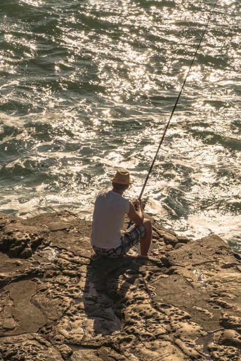
Then there is the Triton gate, crowned by its archway which looks like a coral reef!

lisbon-sintra-cascais-41

While we were visiting the palace, the clouds moved in and out, sometimes giving us a brief glimpse of the Atlantic coast.

lisbon-sintra-cascais-49lisbon-sintra-cascais-57lisbon-sintra-cascais-64

Then the fog and clouds moved back in and started to pour rain. Hence, we got to see how the fun downspouts really work!

lisbon-sintra-cascais-83lisbon-sintra-cascais-84

After having survived the fog and the rain at the Palacio do Pena, we went down to the actual town of Sintra, and saw the National Palace of Portugal. From the town you could look up and occasionally see the Pena Palace and also an old Moorish castle on the top of the mountain.  You could also see the luxurious country estates built by the Portuguese nobility surrounding the town. Many of these were also built in the Bavarian style, so you sort of feel like you are in the Alps.

lisbon-sintra-cascais-103lisbon-sintra-cascais-108

lisbon-sintra-cascais-163

lisbon-sintra-cascais-114
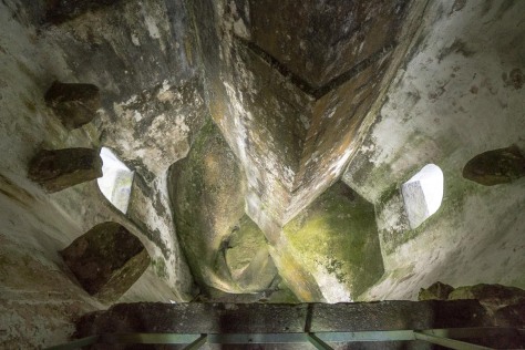
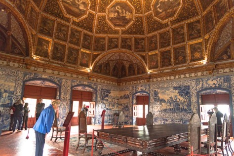
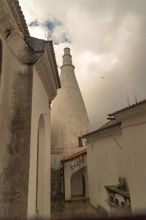
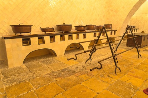
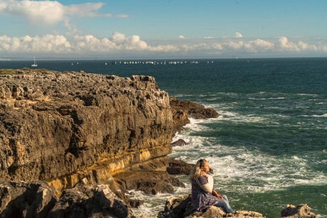
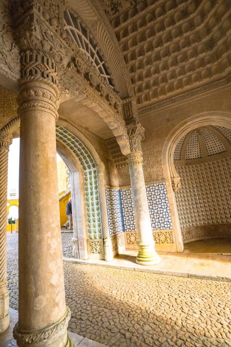
The National Palace is more reminiscent of a hunting lodge, and our guide, Elsa, told us that it was considered to be the “man cave” of the Portuguese nobility. In fact, Portugal’s penultimate king, Carlos, kept both his wife and his mistress ensconced in different parts of the house.  I thought the most interesting feature of the palace were the immense chimneys in the kitchens which looked like giant dunce caps, but allowed for huge spits to operate over raging fires set on the floor of the kitchen.

lisbon-sintra-cascais-125lisbon-sintra-cascais-128

lisbon-sintra-cascais-117

lisbon-sintra-cascais-138lisbon-sintra-cascais-141lisbon-sintra-cascais-142lisbon-sintra-cascais-151lisbon-sintra-cascais-154

Sintra is still a tiny town and as the day wore on, the tour busses and throngs of tourists threatened to overwhelm it.  Accordingly, we decided to hop back in the car and head for the coast. We took the coast road down from Sintra (N247) which provided a very scenic drive through the town of Colares (which used to be a wine growing region). The terrain changes very suddenly from forest to beach, and goes through the town of Guincho, which is a very famous surfing town. We stopped in a cute restaurant here right on the sea, but the waves were so big, no one was braving them.

lisbon-sintra-cascais-167-editlisbon-sintra-cascais-168

We headed further down the coast and made a stop at the famous blowhole called Boca do Inferno (mouth of Hell).  Finally we wound our way back through the seaside resort town of Cascais, which warrants a longer visit in the future.

lisbon-sintra-cascais-170lisbon-sintra-cascais-171lisbon-sintra-cascais-173lisbon-sintra-cascais-182lisbon-sintra-cascais-187

lisbon-sintra-cascais-189lisbon-sintra-cascais-190lisbon-sintra-cascais-194lisbon-sintra-cascais-198lisbon-sintra-cascais-199

After a short rest back at our hotel, Jim and I walked through our Carmo neighborhood and stopped for dinner at one of the many restaurants there. However, our guide had recommended a brewery restaurant, Cervercería Trinidade, and we enjoyed an excellent meal there.  Tomorrow our cruise departs from Lisbon, and we are very excited to see our new home for the next three weeks!


The Gringos Are On the Road Again

Oct. 20, 2016:

Dear Readers:

After almost two months at home (yes, it’s true …we do stay home occasionally), we are setting off on what is, even for us, a wild adventure.  We are sitting in the Admirals Club awaiting our flight to Lisbon, where we will embark upon a small ship adventure from Lisbon, Portugal  to Cape Town, South Africa.

lisbon-departure

Along the way, we will visit the island chains of the Madeira Islands, the Canary Islands and the Cape Verde Islands, before we travel down the west coast of Africa. We stop in the countries of Senegal, Gambia,  Cote d’Ivoire, Ghana, Togo, Sao Tome & Principe, Namibia, and South Africa. Our adventure concludes with a couple of days in Cape Town, where we plan to go wine tasting one day, and on a visit to a game preserve, before we fly home.

One fun thing we decided to do this trip was to create un-business cards for ourselves, so we could stay in touch with folks we meet in our travels, and help them become “Readers” like you.  Our friend, Kate Braid, at Hungry Dog Printing, designed these cool cards for us.

2016_10_20_travel-card-back

2016_10_20_travel-card-front

Hungry Dog Printing is a local Long Beach business and we are happy to support them! (hungrydogprinting.com)

Well, they’re calling our flight. Join us on a new adventure. In other words, “go with the gringos”!

american-plane